Peyton Randolph House Archaeological Report, Block 28 Building 6 Lot 00Originally entitled: "A View From the Top : Archaeological Investigations of Peyton Randolph's Urban Plantation"
Colonial Williamsburg Foundation Library Research Report Series - 175
Colonial Williamsburg Foundation Library
Williamsburg, Virginia
1996
A VIEW FROM THE TOP:
ARCHAEOLOGICAL INVESTIGATIONS OF PEYTON RANDOLPH'S URBAN PLANTATION
Department of Archaeological Research
The Colonial Williamsburg Foundation
Williamsburg, Virginia
February, 1988
ABSTRACT
An intensive archaeological investigation of the back yard of the Peyton Randolph House, an early eighteenth-century structure located within the Historic Area of Williamsburg, took place from the summer of 1982 to the spring of 1985. Although previous archaeological work had been done during the 1930s and 1950s, new methods and techniques as well as a more modern research design required further, more detailed exploration of the area.
In addition to the task of uncovering the foundations of the fifteen outbuildings that stood behind the house during various periods, the project was used as an experimental laboratory for testing archaeological methods and techniques new to Colonial Williamsburg Foundation archaeology. Such methods include the Harris Matrix System, computer entry of context and artifact data, and block excavation.
Aside from the outbuilding foundations, such features as walkways, fence lines, garden patches, and work areas were defined. Beginning with the assumption that changes in the property ownership is reflected in the archaeological record and can be evidenced in the analysis of the site, the archaeology culminated in an interpretation of the way the yard was used during various periods spanning over 250 years.
The excavation performed another important function for the Foundation: the interpretation of an on-going archaeological site to Colonial Williamsburg visitors. This aspect of the project proved quite successful, so much so, in fact, that the experience was repeated in 1987 with an exhibition dig at the nearby Brush-Everard property.
TABLE OF CONTENTS
| List of Figures | i |
| List of Photographs | iii |
| Introduction | v |
| Acknowledgments | vi |
| Chapter 1 - Location, Historical and Environmental Background | 1 |
| Chapter 2 - Previous Archaeology | 9 |
| The First Excavations | 9 |
| The Second Excavations | 11 |
| The Third Excavations | 11 |
| Chapter 3 - Method and Technique | 13 |
| Excavation | 13 |
| Soil | 18 |
| Flotation | 18 |
| Chemistry | 18 |
| Artifacts | 19 |
| Special Studies | 19 |
| Pollen and Parasite Analysis | 19 |
| Thermoluminescence | 20 |
| Dendrochronology | 20 |
| Archaeo-botanical Analysis | 21 |
| Faunal Analysis, Preliminary Report | 21 |
| Chapter 4 - Description of Major Finds, 28G Area | 23 |
| Structure A - Early Eighteenth-Century Dwelling | 25 |
| Structure B - Outbuilding | 41 |
| Structure C - Outbuilding | 44 |
| Structure D - Outbuilding for Structure A | 46 |
| Structure E - Granary (?) | 49 |
| Structure F - Unidentified Building | 53 |
| Topsoil | 54 |
| Modern Disturbances | 56 |
| Plowzone | 58 |
| Brown Sandy Loam 1 and 2 | 60 |
| Walkway #1 | 89 |
| Walkway #2 | 92 |
| Fence Lines | 95 |
| Planting Beds | 102 |
| Middle Plantation Features | 111 |
| Chapter 5 - Description of Major Finds, 28H Area | 115 |
| Modern Intrusions and Topsoil | 115 |
| Marl Walkway #1 | 118 |
| Marl Walkway #2 | 119 |
| Refuse Layer | 121 |
| "Clean" Brown Loam | 126 |
| Fence Lines | 129 |
| Structure G - Dairy (?) | 133 |
| Structure H - Smokehouse (?) | 135 |
| Structure J - Dwelling/Second Kitchen | 138 |
| Structure K - Third Kitchen | 141 |
| Structure L - Fourth Kitchen | 143 |
| Structure M - First Kitchen | 151 |
| Structure N - Shed | 153 |
| Area 28B | 155 |
| Structure R - Unidentified Building | 155 |
| Structure Q - Unidentified Building | 155 |
| Structure P - Dairy | 156 |
| Well | 158 |
| Chapter 6 - Interpretation and Conclusions | 161 |
| Chapter 7 - Artifact Catalog | 183 |
| References Cited | 211 |
| Appendix 1 - | Peyton Randolph's Inventory |
| Appendix 2 - | Humphrey Harwood's Ledger |
| Appendix 3 - | Archaeological Report, September 1939 |
| Appendix 4 - | Archaeological Report, 1978 |
| Appendix 5 - | Pollen and Parasite Analysis |
| Appendix 6 - | Macrofossil Analysis |
| Appendix 7 - | Oral History |
| Appendix 8 - | Dendrochronology Report, 1983 |
| Appendix 9 - | Thermoluminescence Report |
| Appendix 10 - | Dendrochronology Report, 1984 |
| Appendix 11 - | Analysis of Twentieth-Century Cistern Debris |
| Appendix 12 - | Analysis of Oyster Shell |
| Appendix 13 - | Analysis of Faunal Remains from Planting Beds |
| 1.Randolph House and Property Location | 2 |
| 2.The "Frenchman's Map" | 3 |
| 3.Context Record Form | 16 |
| 4.Overall Map of the Excavation Area | 23 |
| 5.Placement of Joist Nails, Interior of Structure A | 26 |
| 6.Detail of Corner Fireplace, Structure A | 27 |
| 7.Profile of Standing Balk in Structure A | 29 |
| 8.Cross-mends to 1955 Trench Fill, Structure A | 30 |
| 9.Structure A, Artifact Scatters | 32 |
| 10.Distributions of Selected Artifacts in Plaster Layer and Below Plaster Layer | 33 |
| 11.Oswald's Simplified Typology | 34 |
| 12.Pipestem Dating: Comparisons to Harrington's Charts and Binford's Regression Formula Dates | 35 |
| 13.Ware Types - Specific Categories | 36 |
| 14.Ware Types - General Categories | 37 |
| 15.Brick Feature over South Wall of Structure A (from J.M.K. map) | 42 |
| 16.Structure F (from J.M.K. map) | 52 |
| 17.South Wall - 1982 Excavation Area | 54 |
| 18.Artifact Distribution Based on Piece-Plotting | 62 |
| 19.Artifact Distribution Based on 2.5 x 2.5 Foot Sub-units | 62 |
| 20.Artifact Distribution Based on 5 x 5 Foot Units | 62 |
| 21.Artifact Distribution Based on 10 x 10 Foot Units | 62 |
| 22-30.Artifact Distribution Maps, BSL1 | 64-77 |
| 31-44.Artifact Distribution Maps, BSL2 | 78-86 |
| 45.Ceramic Size Form | 88 |
| 46.Walkway #1, 28G Area | 90 |
| 47.Walkway #2, 28G Area | 93 |
| 48.Eastern North-South Fence Line | 96 |
| 49.Western North-South Fence Line | 97 |
| 50.East-West Fence Line | 98 |
| 51.Central North-South Fence Line | 100 |
| 52.Excavation Divisions, Planting Beds 1 and 2 | 104 |
| 53.Detail of Paving Material, Planting Beds 1 and 2 | 105 |
| 54.Middle Plantation Era Boundary Ditch with Associated Post Holes | 111 |
| 55.Marl Walkway #1, 28H Area | 118 |
| 56.Marl Walkway #2, 28H Area | 119 |
| 57.Refuse Layer, 28H Area | 121 |
| 58.Artifact Distribution, Clean Brown Layer | 126 |
| 59.Fence Line | 129 |
| 60.Admiral Vernon Commemorative Buckle | 139 |
| 61.Exterior Northwest Wall, Structure L | 147 |
| 62.Remains of Piers Supporting Covered Way | 148 |
| ii | |
| 63.Periodization Map 1 (Pre-1699) | 163 |
| 64.Periodization Map 2 (1715-1724) | 165 |
| 65.Periodization Map 3 (1724-1737) | 167 |
| 66.Periodization Map 4 (1737-1755) | 168 |
| 67.Periodization Map 5 (1755-1775) | 170 |
| 68.Periodization Map 6 (1783-1800) | 172 |
| 69.Periodization Map 7 (1800-1860) | 174 |
| 70.Periodization Map 8 (1860-1900) | 176 |
| 71.Periodization Map 9 (1900-1920) | 178 |
| 72.Periodization Map 10 (1920-1938) | 179 |
| 73.Periodization Map 11 (1938-1985) | 180 |
| 74.English Beverage Bottle | 185 |
| 75.Stoneware Tankards | 187 |
| 76.English Delftware Fireplace Tile | 189 |
| 77.Chinese Porcelain Vessels | 191 |
| 78.English Delftware Vessels | 193 |
| 79.Staffordshire Red Sandyware and Colono-Indian Ware Vessels | 195 |
| 80.Chinese Porcelain Vessels | 197 |
| 81.English Glass Beverage Bottles | 199 |
| 82.Fulham-Type Brown Stoneware Tankard | 201 |
| 83.English Delftware Vessels | 203 |
| 84.Coarseware Vessels | 205 |
| 85.Glass Bottle Seal | 207 |
| 1.Peyton Randolph House - South Elevation | 1 |
| 2.Reconstructed Outbuilding - Structure N | 9 |
| 3.East Elevation of House, Before Restoration | 10 |
| 4.Excavation of the Foundations of Structure S in 1938 | 10 |
| 5.Structure A | 25 |
| 6.Rowlock Wall Under Foundations of Structure A | 27 |
| 7.Detail of Fireplace "Wing" | 28 |
| 8.Structure B | 41 |
| 9.Articulated Remains of Rooster | 43 |
| 10.Articulated Remains of Duck | 43 |
| 11.Structures C and D | 44 |
| 12.Structure D | 46 |
| 13.Structure E | 49 |
| 14.Detail of Collapsed Pier, Structure E | 50 |
| 15.Miller, Skillman, and Donegan Houses | 55 |
| 16.Post Hole Through East Wall, Structure E | 58 |
| 17.Walkway #1, 28G Area | 89 |
| 18.Walkway #2, 28G Area | 92 |
| 19.Eastern North-South Fence Line | 95 |
| 20.Different Uses of Back Lot on Either Side of Eastern Fence Line | 96 |
| 21.Differential Drying of Planting Beds 1 and 2 | 102 |
| 22.Planting Beds 1 and 2, Unexcavated | 103 |
| 23.Overall, Planting Beds 1 and 2 | 106 |
| 24a.Planting Bed 3, Looking South | 107 |
| 24b.Planting Bed 3, Looking North | 107 |
| 25.Planting Bed 4 | 109 |
| 26.Telephone Line in 28H Area, 1955 | 116 |
| 27.Late Nineteenth-Century Windmill at Peyton Randolph Site | 116 |
| 28.Structure G | 133 |
| 29.Structure H | 135 |
| 30.Surviving Outbuildings Behind the Peyton Randolph House , c. 1900 | 137 |
| 31.Structure J | 138 |
| 32.Structure K | 141 |
| 33.Structure L | 143 |
| 34.Structure L, Cement Removed | 145 |
| 35.Interior, East Wall, Structure L | 146 |
| 36.Circa 1870 Photograph Showing Kitchen Building Behind Main House | 149 |
| 37.Structure M | 151 |
| 38.Structure N (1938) | 153 |
| 39.Structures P, Q, and R | 156 |
| 40.The Well | 158 |
| 41.Effects of Tunnel Construction on Structure S | 162 |
| 42.South Elevation of House, circa 1870 | 175 |
INTRODUCTION
The last phase of archaeology undertaken on the Peyton Randolph lot (Colonial Lot 207?) was begun July 7, 1982, and continued through early spring of 1985. The project was funded by the Rockefeller Brothers Fund as part of a gift to the Colonial Williamsburg Foundation for intensive archaeological investigation and the eventual reconstruction of the appropriate outbuildings behind the house. The project was the first major undertaking of the newly-established Office of Excavation and Conservation, now the Department of Archaeological Research, under the direction of Marley R. Brown III.
The overall project supervisor was Robert C. Birney, Senior Vice President, Education, Preservation, and Research.
Adrian Praetzellis was the field, supervisor for the first two months of the project, after which Linda K. Derry served in that capacity until the spring of 1983. From spring of 1983 until the culmination of the field work in 1985, Andrew C. Edwards was the site supervisor, assisted by Roy A. Jackson.
The research design for the archaeology of the site was two-fold in nature. Primarily, the purpose of the excavations was to produce an accurate chronology of the lot, including structures and activity areas from the time of the construction of the main house in the second decade of the eighteenth century to the present. In addition to this rather straightforward periodization of the investigated area, the Peyton Randolph excavation served as a proving ground for testing the viability of new recovery techniques, the computerization of site data, and the institution of various recording forms. The value of data recovered from contexts disturbed by previous excavations was also tested at Peyton Randolph. The methods and techniques used in the excavation process proved to be invaluable in subsequent archaeological endeavors throughout the Historic Area.
The two-fold research design at Peyton Randolph has spawned two types of reports on the archaeology. This, the descriptive and interpretive report, addresses the primary periodization approach to the lot, outlining the temporal frames for possible reconstruction purposes. A second, more academically oriented monograph is in the process of production and will address the more theoretical aspects of recovery technique, in-depth analysis of artifact types and their distribution, and the relative importance of data from disturbed contexts.
The following report is essentially descriptive in nature, outlining the various structures and significant features discovered or rediscovered during the course of excavation. The final chapter attempts to place these structures and features into various time frames and explain as best as possible the metamorphosis of the Randolph House back lot from the Middle Plantation period to the present.
An excellent architectural assessment of the main house and the outbuilding foundations was submitted by Willie Graham of Colonial Williamsburg's Department of Architectural Research in December of 1985 (Graham 1985). That report, the house history (Stephenson 1952, revised by Carson in 1967), the documentary report (Gibbs 1978), and this report should provide a firm basis for the reconstruction and interpretation of the Peyton Randolph outbuildings.
ACKNOWLEDGMENTS
The Peyton Randolph Project, undertaken by the Office of Excavation and Conservation, involved many people and several departments over the past four years. It is nearly impossible to specifically acknowledge everyone who has had a part in the project's successful completion. The authors would like to thank the following individuals for their contributions:
Robert C. Birney, Senior Vice-President, Colonial Williamsburg Foundation (CWF), who not only guided the funding of the projects, but offered his support, ideas, and knowledge throughout the excavations and report-writing period.
Ivor Noël Hume, Foundation Archaeologist (Rtd.), CWF, who examined several important features found on the site and offered his expert interpretation and advice. Mr. Noël Hume also began the preliminary excavations around Structure A in 1978.
Niel Black, Miller, CWF, and Windmill staff who cheerfully tolerated the horde of muddy excavators sharing the Windmill employee lounge, the visitors' many questions about the archaeology, and the often unsightly mess associated with excavation.
Dennis O'Toole, Vice-President, Historic Area Programs and Operations, CWF, and his staff of outstanding interpreters, who, through heat, rain, and chilling winds often talked themselves hoarse ably interpreting the sometimes confusing process of archaeology to throngs of visitors.
Gertrude Deversa, Life Tenant, Peyton Randolph House, who also cheerfully tolerated the disruption caused by the archaeological process, provided us valuable information about the house and yard, and more than once provided refreshments to a hot and tired group of excavators.
The Peyton Randolph House Staff, who never complained of the inconvenience caused by the archaeology, answered many visitor questions, and often tracked down one of the supervisors or crew in order to deliver telephone messages.
Ed Chappell, Willie Graham, and Nick Pappas who avidly followed the progress of the excavations, brought in architectural experts, helped sort out the profusion of foundations, and always offered encouragement.
James Knight, who directed the previous excavations in the 1930s and again in the 1950s at Peyton Randolph. His recollections and advice were invaluable.
Colonial Williamsburg's Landscape Department for providing the cherry picker for aerial photographs and for helping us keep the site looking as good as possible.
viiThe excavators and field technicians who accomplished the task included:
| Ramona Avallone | Tom Hayman | Roni Polk |
| Steve Alexandrowicz | Jeff Holland | Janet Rocha |
| Tad Baker | Alison Helms | Don Roland |
| Andrew Barski | Patrice Jeppson | Barbara Seligmann |
| Steve Beauter | Elizabeth Jorgensen | Sam Shogren |
| Ross Becker | Simon Krauss | Susan Stanford-Stoney |
| Amy Bennett | Anne Kushnick | Tony Stockbridge |
| Lisa Broberg | Rebecca LaFontaine | Chris Styrna |
| Greg Brown | Mark Lawall | John Sprinkle |
| Mark Canada | Melanie Liddle | Nate Smith |
| Mark Cravalho | Mike Meyer | Charles Thomas |
| Jim Csigas | Linda Myers | Karin Vanderpeer |
| Felicity Devlin | Susan Mira | Lucie Vinciguerra |
| Robin Duffy | Charlie McNutt | James Wilson |
| Andrea Foster | David Muraca | Wheeler Wood |
| Cecile Gaskell | Dan Nolin | Ian Wilmshurst |
| Lynn Gentemann | Ann Plane | Mary Zylowski |
| Hannah Gibbs | Tom Polk |
The following members of the Laboratory Staff expertly identified and processed the 250,000+ artifacts recovered:
| Susan Alexandrowicz | Leslie McFaden |
| Elizabeth Bush | Lisa Pittman |
| Jenny Carr | Monica Perry |
| Tara Goodrich | Kathleen Pepper |
| Paula Lampert | Wright Robinson |
Adrian Praetzellis was the first crew chief at Peyton Randolph, getting the excavations off to a good start.
Len Winter was instrumental in establishing the initial grid system.
Charles Hodges, Staff Archaeologist at Flowerdew Hundred was kind enough to secure a transit for the above exercise.
The following staff members played very important roles in the completion of the project:
- Patricia Samford for technical assistance
- Robert Hunter for technical assistance, computer
- William Pittman for supervision of the lab and aid in procurements
- viii
- Virginia Caldwell for drafting and surveying assistance
- June (Nan) Reisweber for administrative assistance and patience
- Curt Moyer for expert conservation of artifacts
- William Adams for advice and guidance
- Tamera Mams for photographic assistance
- George Miller for technical assistance, artifacts
- Gregory Brown for proof-reading, editing, and offering numerous excellent suggestions about content and style. His expertise in the use of WordPerfect and the Hewlett Packard LaserJet+ were invaluable in the report production.
- Hannah Gibbs McKee for her excellent design creations and her exhaustive work in actually laying-out the report and coordinating its production.
CHAPTER ONE:
LOCATION, HISTORICAL AND ENVIRONMENTAL
 PHOTO 1 — Peyton Randolph House — South Elevation
The Peyton Randolph House (see above) is located within the Historic Area of the City of Williamsburg, on the northeastern corner of Nicholson and North England Streets (Fig. 1). The so-called Frenchman's Map, allegedly drawn by an unknown French military cartographer in 1782, clearly depicts the house with the older west and east wings connected by the central section in much the way the house stands today (see Fig. 2). It does not, however, indicate any outbuildings associated with the structure. Very few dependencies appear on the early map, probably because of the relative unimportance with which such structures were viewed. The front of the Randolph House faces Market Square to the south, as it has since the construction of the mid-section, probably in the 1750s. Before this time, when the present west wing stood alone, the house would have likely faced west, towards Palace Green, with the few outbuildings placed along the north side of the structure, perhaps facing west as well.
This change in orientation was probably a reflection of several occurrences in the period from 1715 to 1760. Market Square became a popular area for trading, probably acquiring a market house by 1757, and had gained a public atmosphere. 2 The present court house was built on the Green by 1770, further enhancing the popularity of the area. The change from west to south may also have been influenced by the construction of Tazewell Hall by Peyton's brother John Randolph about 1762. Tazewell Hall is located at the end of South England Street, almost directly south of the Peyton Randolph House. Hampered only by the Powder Magazine, the two brothers could have their houses facing each other, sharing the "vista."
Whatever the reason, the effects of the re-orientation probably resulted in the rearrangement of the dependencies. This change is reflected in the archaeological findings and is the crux of the three-year investigation. The change, and the supporting evidence, will be elaborated upon in the interpretive section of this report.
 Figure 1 — Randolph House and Property Location
 Figure 2 — The "Frenchman's Map"
LOT HISTORY
The use of the area presently occupied by the Peyton Randolph site during the Middle Plantation era (1634-1699) is generally unclear. The only archaeological feature representing this time period was a boundary ditch crossing the site in a northwest-southeast direction. This ditch may be related to the palisade which was built in 1634, traversing the entire Middle Peninsula between what are now called College and Queen's Creeks. No other conclusively seventeenth-century or aboriginal features were encountered during the course of excavation.
The first historical documentation involving the area under investigation was on November 11, 1714, when the Trustees of the City of Williamsburg conveyed eight lots to William Robertson. The lots sold to Robertson were numbered 232, 233, 234, 235, 236, 237, 207, and 208 on the City Plat. Unfortunately, the first plat of the city no longer exists, and the exact location of the numbered lots is not known. However, careful examination of the surviving historical records has placed the lots mentioned above in the block bounded by the eighteenth-century locations of Scotland Street on the north, N. England Street on the west, Nicholson Street on 4 the south, and Queen Street on the east. Their configuration was probably as follows:

Written in the conveyance of the eight lots to Mr. Robertson was the stipulation that he build upon each of the lots within two years, or they would revert to the Trustees:
… that if the said Wm. Robertson his heirs or Assigns shall not within the space of Twenty four Months next ensueing the date of these Presents begin to build & finish upon Each Lott of the said granted Premisses One good Dwelling house or houses of such dimensions & to be placed in such manner as by One Act of Assembly made at the Capitol the 23d day of October 1705 … then it shall & may be lawful to & for the said Feoffees or Trustees & their succesors Feoffees or Trustees for the Land appropriated for the building & Erecting … to have hold & Enjoy in a like manner as they might otherwise have done if these Presents had never been made (Stephenson 1952, from York County Deeds and Bonds, III, 28-29).
Apparently Robertson found himself unable to meet these requirements, because on November 19, 1715 he sold lots 233 and 234 to Philip Ludwell. On April 20, 1717 the Trustees gave title of lot 232 to John Tyler, who was apparently already living on it. Again, on January 17, 1718 the Trustees conveyed title to lot 235 to Samuel Cobbs, also already in possession. Robertson was able to retain four of the lots, however, until 1723 when he sold them to John Holloway. At that time the lots contained several houses, orchards, and a windmill (Stephenson 1952).
In July of 1724, only six months after he had purchased the four lots, Holloway sold one lot, probably 237, to John Randolph. The record of sale describes the lot as "… adjoining to the Lot whereon the said John Randolph now lives …" The record also mentions "messuage" on the lot, which probably describes a building built by Robertson soon after the initial purchase in 1714. How Randolph acquired the adjacent lot on which he lived at the time of this sale, presumed to be 207, is unclear. There is also a real possibility that the lot Randolph bought from Holloway was actually 207 and he was already residing in Structure S on lot 237. Since there is no record of the prior sale in the York County records, the assumption is that the transaction was recorded in the Hustings Court or in General Court, the records for which have not survived. Randolph sold the only other lot he owned (174) to Archibald Blair the same day in 1724 that he bought 237. The exact location of lot 174 is not known, but consensus has placed it across N. England Street on the southwestern corner of England and Scotland Streets.
John Randolph, new owner of lots 207 and 237, was born at his family home at Turkey Island in 1693. He attended the College of William and Mary from 1709 5 to 1711, becoming Deputy Attorney General for the Counties of Charles City, Henrico, and Prince George in 1712. Between the years 1715 and 1717, he traveled to England to study law. Upon his return to Williamsburg, Randolph was appointed clerk of the House of Burgesses. After serving as agent for the Colony for many years, in 1732 he became the only colonial Virginian to be knighted. He was elected Speaker of the House of Burgesses in 1734 and remained "Mr. Speaker" until his death in 1737.
John Randolph married Susannah Beverley of Gloucester County around 1718. At the time of his death, four children were surviving: Beverley, born c. 1720; Peyton, born c. 1721; John, born c. 1727; and Mary, whose birth and death dates are not known. Susannah Randolph survived her husband and remained owner of the house until her death sometime after 1754. It is at this date that the last historical reference to Lady Randolph appears. The exact date of her death and place of burial, however, are unknown.
The Randolph's eldest son Beverley resided in Gloucester, becoming a Burgess for the College and later Sheriff of Gloucester County. Younger son John Randolph (often known as John Randolph the Tory) became a prominent lawyer, Burgess, Attorney General and Speaker of the House. He was also quite interested in horticulture, probably writing A Treatise on Gardening by A Citizen of Virginia around 1765. Perhaps wanting a home commensurate with his brother's, he built Tazewell Hall, the largest private residence in the city, on South England Street. When the break with Great Britain came, John fled to England. His body was returned to Williamsburg after his death in 1784 and was buried alongside his father and brother in the vault at the College of William and Mary.
Peyton Randolph, just as his father and brother, attended the College of William and Mary and studied law in England. He was admitted to the bar on February 10, 1742/3 and began his career as Attorney General for the Colony on May 7, 1744. Soon afterward, on March 8, 1745/6, he married Betty Harrison of Berkeley. They resided at his mother's house where Peyton had grown up. Peyton's public life continued in various assignments as Attorney General, with increasing involvement in inter-colonial affairs. He was elected Speaker of the House in 1766. As the problems leading to the eventual revolution were becoming more apparent, Peyton Randolph was increasing his contact with prominent personalities from the other colonies. In 1774 the First Continental Congress met in Philadelphia, and Randolph was unanimously elected president. He was also president of the Second Continental Congress, held on May 10, 1775. Declining health prevented Peyton Randolph from continuing to preside over the Congress, although he was in attendance to see John Hancock elected to his former position. Peyton Randolph died in Philadelphia of what seems to have been a stroke at about eight in the evening on October 22, 1775. He was buried in the chapel at the College of William and Mary.
Peyton Randolph was survived by his wife, Betty, who inherited his entire estate since the couple had no children. Betty Randolph also survived the Revolution and the occupation of the city of Williamsburg by Lord Cornwallis' troops. She died in 1783 and was probably buried in the vault at the College with her husband.
6The following advertisement of public auction appeared in the Virginia Gazette on February 15, 1783:
TO BE SOLD, By public auction, in Williamsburg, on Wednesday the nineteenth of February next, The houses and lots of the late Mrs Betty Randolph, deceased, together with a quantity of mahogany furniture, consisting of chairs, tables, mahogany and gilt framed looking glasses, and desks, a hansome carpet, a quantity of glass ware and table china, and a variety of other articles; also kitchen furniture complete. The above mentioned house is two story high, with four rooms on a floor, pleasantly situated on the great square, with every necessary outhouse convenient for a large family, garden and yard well paled in, stables to hold twelve horses, and room for two carriages, with several acres of pasture ground. Twelve months credit will be allowed for all sums above five pounds, on giving bond with approved security, to carry interest from the date if not punctually paid. The EXECUTORS. (Stephenson 1952).
The house was sold to Joseph Hornsby on February 21, 1783. Hornsby sold the property to Thomas Peachy sometime around 1800, but the record of the transaction has been lost. The house remained in the Peachy family until the late 1860s when it was sold to Richard Hansford. The succession of ownership for the remainder of the nineteenth century to the present is as follows:
| 1884-1893 | Moses R. Harrell |
| 1893-1897 | John Dahn |
| 1897-1920 | E.W. Warburton |
| 1920-1921 | Williamsburg Inc. (real estate company) |
| 1921-1927 | Mary Proctor Wilson |
| 1927-1938 | Merrill Proctor Ball |
| 1938-present | Colonial Williamsburg Foundation. |
Merrill Proctor Ball's daughter, Gertrude Deversa, continues to occupy the east wing of the house as her residence. Her recollections of living in "Mr. Speaker's" house are related in the oral history section of this report.
ENVIRONMENTAL SETTING
The Historic Area of the City of Williamsburg is situated along a drainage divide running east-west along the peninsula. The ravines cutting into the dividing ridge from the south eventually channel run-off water into the James River, whereas those on the north side of Duke of Gloucester Street direct the flow into the York River. The area around the Peyton Randolph House has an elevation of about 80-85 feet above mean sea level. A fairly steep ravine which existed just to the east of the back lot became in the early 1940s the location for the Colonial Parkway tunnel.
Since the setting is now semi-urban, much of the flora around the Peyton Randolph House is cultivated rather than wild. Walnut, pecan, weeping willow, and crepe myrtle are but a few of the trees surrounding the yard. In earlier periods, however, Williamsburg had the characteristic flora of the Southeastern Coastal Plain—typified by temperate deciduous forests with areas of black and loblolly pines. 7 All of the Williamsburg area has been logged many times over the past 350 years, undoubtedly altering the landscape and ecology considerably.
Various faunal species common in the area in the eighteenth century are still found in Williamsburg and its environs. White-tailed deer, which are rather prolific on the outskirts of town, especially in protected areas along the Colonial Parkway, are not found in the Historic Area. However, grey squirrel, raccoon, opossum, skunk, rabbit, mice, and rats live peacefully within the town. Even occasional grey and red foxes are seen within the city limits. Birds common in the area include many types of water fowl, song birds, eagles, hawks, and vultures. Snakes, land and riverine turtles, fish, shellfish, and crabs are found in abundance in stream-side and marshland environments.
The climate of the Williamsburg area is fairly mild, mitigated by its proximity to the Chesapeake Bay and the Atlantic Ocean. The average annual temperature is 59° Fahrenheit, with the average winter temperature 38.9° F and the average summer temperature 76.8° F (Lewis 1975:141). Extremes in temperature do occur, however, both in the winter and the summer. Fifteen degree temperatures in January and February are not uncommon, and readings in excess of 100° F in July are predictable. The average annual rainfall is 42.5 inches, with occasional snow (Bick and Coch 1969).
8CHAPTER TWO:
PREVIOUS ARCHAEOLOGY
THE FIRST EXCAVATIONS
The first archaeological excavations in the Peyton Randolph back yard were begun by the Colonial Williamsburg Foundation's Architecture Department in November 1938. The work was done under the direction of Francis Duke and was completed in the early fall of 1940 (The Archaeological Report is included in Appendix 3.) The primary objectives of the early excavations were to supply details for the reconstruction of the then no-longer standing east wing of the house, as well as for the most accurate possible restoration of the main house. One must assume the diggings in the back yard were aimed towards the eventual reconstruction of the various outbuildings, but only one small building was actually reconstructed. This structure, a shed, was constructed on original eighteenth-century foundations in 1940 (Photo 2).
The so-called "east wing" of the house was thought to have been a separate building, later connected to the original main structure by the central section. This building (Structure S) had been razed before modern memory, and does not appear in any of the early photographs of the Randolph House. The only evidence of the structure prior to the 1939 archaeology was its apparent presence on the Frenchman's Map and a "scar" left on the exterior east wall of the connecting central section (see Photo 3)—the only above-floor-level brick wall in the entire Peyton Randolph House.
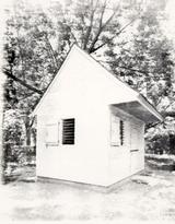 Photo 2. - Reconstructed Outbuilding - Structure N
Excavations in 1939, prior to the construction of the house to its present appearance, revealed a 20 by 35 foot foundation some 15 inches thick forming a cellar under the east wing. The cellar had two levels of paving with a fireplace and chimney base built along its north wall.
Many photographs were taken during the 1930s reconstruction/restoration and archaeology. One of the more revealing was taken of the excavated cellar in the east wing (Photo 4), showing a dump truck in the background. This confirms the suspicion that much of the fill removed from the site during the excavations was transported elsewhere. Given this indication, it appears, with little leap of logic,
10
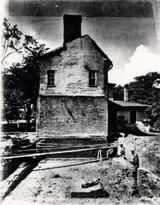 Photo 3. - East Elevation of House, Before Restoration
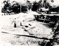 Photo 4. - Excavation of the Foundations of Structure S in 1938
that the backfill dumped after completion of the 1930s archaeology may have been brought in from another site. This supposition significantly affected the treatment of the backfill during the 1982-1985 excavations.
In addition to the excavation of the east wing foundations, the work in the late 1930s attempted to clarify changes in the various entrances to the house. Most significant among these were the entrances to the basement under the older west wing of the house. The excavators located a bulkhead entrance in approximately the same location as the reconstructed one is today, and another just to the east. The first entrance had been altered several times. The oldest entrance was from the north, but was changed to the west with the addition of the covered passageway from the kitchen. Later, the access to the basement was moved to the east and a porch placed over the former bulkhead. It is unlikely that the present reconstructed porch-tower existed at the same time as the covered passageway from the kitchen.
The outbuilding area, or back yard of the Peyton Randolph House, was also investigated in the 1930s. East of the marl walkway, which currently exists extending northward from the entrance to the central section of the house, the foundations of four outbuildings were located. Three were superimposed upon each other and probably represent storage buildings. The fourth was located just to the south of these and was reconstructed as a shed. More information regarding these structures is included in the main body of this report.
Documentation of the early excavations was reasonably complete considering the standards of the time period. Somewhat detailed maps were made of the excavation areas, and several photographs were taken which proved invaluable to the later excavators. Unfortunately, a significant amount of information was lost due to the destruction of several builder's trenches and the interruption of 11 stratigraphic sequences. Also unfortunate was the apparent apathy towards artifacts which is reflected in this passage from the 1939 Archaeological Report:
Few fragments, and none of importance, were found among the outbuildings. The east wing excavation yielded some china fragments in unusually good preservation, some of them being almost whole pieces. But nothing was found of particular architectural interest. Fragments were consigned to the Educational Department (Archaeology) (Duke 1939:15).
THE SECOND EXCAVATIONS
Another section of the current area of investigation was excavated in 1955, by a crew directed by James Knight of the Architecture Department. The method of excavation had by this time changed from the relatively haphazard digging carried out in the 1930s to systematic cross-trenching. The area cross-trenched extended from the edge of the earlier excavations all the way to Scotland Street, a plot of several acres. Three twentieth-century houses were still standing when the cross-trenching took place. Although the presence of these houses impeded the trenching operation, oral history informants maintain that all three structures contained basements, and thus the archaeological record in the area of the houses was already obliterated.
The newly-instituted method of cross-trenching consisted of digging parallel trenches to subsoil, measuring a shovel blade in width and a shovel handle apart, at forty-five degree angles to the north-south layout of the city. Such a technique would easily locate brick foundations. When a brick foundation was encountered, the walls were followed, thereby exposing the building. Scale drawings were made of the foundations, but no record was kept regarding the location of the trenches. Seven structures and a well were discovered during the 1955 excavations. Some regard for recovered artifacts was expressed at this time, although the provenience is less than exact and many fragments were given to the people who lived in the houses on the lot. Interviews with the surviving members of the excavation crew, and the results of the later archaeology, indicate that some soil around the newly-discovered foundations was screened (Derry and Brown 1987). The cross-trenches were refilled with virtually the same earth that was removed (except where screening occurred). This fact, given the great amount of area that was cross-trenched in the Historic Area during that period, greatly influenced the treatment of the trench backfill in the 1982-85 excavations.
THE THIRD EXCAVATIONS
The third excavations were a preliminary investigation of a portion of one of the outbuildings located during the 1955 cross-trenching expedition. These were conducted in the winter of 1977-78 by the Department of Archaeology under the direction of Ivor Noël Hume. An interim report on the findings, written by Eric Klingelhofer, is included in Appendix 4. This brief excavation was the first carried out by a trained archaeologist and the first to give credence to a refined 12 stratigraphic sequence. In addition, Mr. Klingelhofer's notes on the excavations were organized using the Harris Matrix System, a concept that was also employed in the later work. These preliminary excavations were limited to the western half of Structure A, which was then covered with a temporary structure rather than backfilled.
CHAPTER THREE:
METHOD AND TECHNIQUE
EXCAVATION
The back lot of the Peyton Randolph House was the first major excavation carried out by the newly-established Office of Excavation and Conservation. The specific goals of the project were primarily to provide information leading to the reconstruction of the appropriate dependencies, walkways, fence lines, garden features, and work areas. In addition to these rather straight-forward "where", "what", and "when" questions, there was the opportunity to address questions regarding, for example, the value of data gathered from disturbed contexts, the significance of close spatial control (even piece-plotting) on a prolific urban site, and the uses of in-depth soil analysis. Because of these and other more open-ended research goals at Peyton Randolph, the system used was an adaptation of a system that British archaeologists Biddle and Kjøbye-Biddle (1969), Barker (1982), and Harris (1979) have been using for many years known as "open area excavation." Open area, or "block," excavation does not use standing balks between squares for stratigraphic reference. Although the method was new to Colonial Williamsburg archaeology, and most historical archaeology done in the Tidewater Virginia area, it is hardly new to America. This approach was taken in the 1950s by Binford at Hatchery West (1970), and was presented as a method for carrying out settlement/subsistence studies in American archaeology by Struever in the 1960s (Struever 1968).
The decision to eliminate the traditional balks was prompted by a change in some research goals. Hester, Heizer, and Graham, in their text on field methods (1975), suggest that the square and balk method has primarily been used to explore "vertical" problems such as chronological sequences of artifacts. The best available chronological description of colonial artifacts, Noël Hume's Guide to Artifacts of Colonial America (1969a), as well as a number of pamphlets and journal articles on the same subject, was a product of the square and balk method. However, Hester, Heizer, and Graham caution that "if one is seeking 'horizontal' information, then one should work for broad exposure of buried cultural remains, using large-area excavation" (1975:76). Because, as stated earlier, the purpose of the Peyton Randolph excavations is to offer a reconstruction of the back yard by detailing the nature of the spatial divisions and the use of particular areas in the past, broad horizontal exposure was a logical choice.
Vertical information need not be forfeited using this excavation approach. Sections formerly drawn from standing balks can be created from detailed elevation records and plan maps. Elevations are taken at least every 2.5 feet, more often in areas of complex stratigraphy. Many more cumulative section drawings can be generated from these records because one is not limited to those sections left 14 standing. Additionally, many archaeologists have found single standing sections "grossly misleading" (Barker 1982:44).
Open area excavation best suits large sites with complex stratigraphy, a description that aptly describes the Peyton Randolph site. Project goals required establishing the function of individual outbuildings or activity areas during various periods of use. This involved the isolation of living surfaces, features, and other deposits contemporary with the use of each building and the recognition of meaningful groups of features (macro-features). Of particular importance is the ability to accurately separate intact layers, then recognize and correlate contemporary stratigraphic units over a broad area. This has proven to be a complicated task for the Peyton Randolph back lot, where intensive occupation over two centuries has been combined with previous "archaeological" trenching to produce a very complex and disturbed stratigraphic sequence. Leaving many large unexcavated balks of soil would only obscure much of the stratification on the site, further complicating matters. To a field archaeologist trying to follow a consistent layer across a site, there is little difference between the destroyed stratigraphy in a 1955 cross-trench and the inaccessible strata in a standing balk.
In order to ensure that meaningful spatial patterning of the recovered artifacts at Peyton Randolph was recognized, a basic coordinate system was used to establish a grid. The north-south baseline was laid along North England Street, with "point zero," an arbitrarily selected point, near the corner of North England and Nicholson Streets. East-west grid coordinates were projected at ten-foot intervals from the north-south baseline. The site lies entirely within the northeast quadrant of the system. The ten-by-ten-foot units were laid out, and each was designated by its northwest corner stake. Each of these standard ten-foot squares was further subdivided into sixteen two-and-one-half foot sub-units. The exact horizontal and vertical coordinates of all diagnostic artifact groups, features and structural remains were also established using this grid system and a fixed datum point. Tightly controlled locational data was gathered so that, when appropriate, they could be subjected to computerized spatial mapping programs ranging from absolute three-dimensional graphic plotting to simulated two-dimensional distributional plotting (e.g., SASGRAPH). Such computerized mapping could supplement field identification of artifact concentrations and recognition of their broader spatial patterns through careful exposure in situ. Previous work on many historic sites has demonstrated the usefulness of these mapping programs in identifying specific patterns of refuse deposits and areas in which specific activities occurred. Many of these patterns and activity areas could not have been determined by visual inspection of excavation units alone.
Abandoning the extensive use of balks and increasing the control over provenience required some alteration in the recording system. Context numbers were given to both units of stratification and certain types of interfaces following the guidelines suggested in the Harris Matrix System, (Harris 1979:59). In order to reduce the size of the number labeled on individual artifacts, record spatial control, and facilitate computer mapping, each context number represents not only a particular unit of stratification, but a specific ten-foot section of that unit. For example, plowzone in the 250N 100E unit was given the context number 271, but the same layer in 260N 100E was given the number 272. Finer divisions of layers were obtained by dividing the unit into sixteen equal 2.5-foot-square sub-units, each designated by an alphabetic tag following the context number.
15Once a layer or a feature was uncovered and defined it was given a context number. These numbers were assigned sequentially as the context was defined. Each context was described on the CONTEXT RECORD SHEET (Fig. 3). A description of the form and its contents are as follows:
| 01. | CONTEXT # - | self-explanatory |
| 02. | PROJECT - | project name, e.g., PEYTON RANDOLPH |
| 03. | DATE - | date context number assigned |
| 04. | SITE - | block and area, e.g., 28G, 28H |
| 05. | UNIT - | coordinates of the northwestern corner of the unit containing the layer or feature being described. |
| 06. | TYPE - | what the context represented, e.g., plowzone, disturbance, layer, feature, post hole, etc. |
| 07. | GENERAL DESCRIPTION - | brief description of the location and salient characteristics of the context |
| 08. | STRATIGRAPHIC CONTEXT | relationship of the context with others |
| 09. | SOIL CONDITION | relative amount of moisture in the soil |
| 10. | SOIL COLOR | Munsell number |
| 11. | LT. MTR. | f-stop and shutter speed of light when the soil color determined (using standard setting of 100 ASA) |
| 12. | SOIL TEXTURE | relative amounts of clay, silt and sand |
| 13. | SAND TEXTURE | sand grain size |
| 14. | SOIL COHERENCE | degree of cohesiveness of soil particles |
| 15. | MOTTLINGS | description of the five most prevalent mottlings in order of frequency |
| 16. | ORGANIC REMAINS | choice of inclusions, if any |
| 17. | INORGANIC REMAINS | choice of inclusions, if any |
| 18. | BOUNDARY/INTERFACE DELINEATION | description of the area of contact between two contexts |
| 19. | SKETCH # | number of all field drawings in which the context appears |
| 20. | PHOTO # | number of all photographs in which the context appears |
| 21. | SOIL SAMPLE # | site plus context number |
| 22. | PEEL # | site plus context number |
| 23. | WET SCREEN # | site plus context number |
| 24. | RECORDED BY | three initials of the person filling out the form |
| 25. | EXCAVATED BY | three initials of the person(s) excavating the context |
| 26. | TPQ | terminus post quem date added to the record after artifacts have been examined by the lab |
| 27. | METHOD | whether the context was excavated by unit, sub-unit, or individually, and screen size |
| 28. | APPROVED BY | initials of the field technician who approved the information on the record |
| 29. | ENTERED BY | initials of the person entering the data into the computer |
 Fig. 3 - Context Record Form
In order to enter this data into a computer for easy management, two masks were created using INFOSTAR+ (version 1.6, 1984). The CONTEXT RECORD SHEET was divided into two forms for data entry purposes because of the large amount of disk space required for the more than 3000 contexts. The first mask contained all data on the sheet except the STRATIGRAPHIC CONTEXT information. The second mask containing this data was used to construct a Harris Matrix (Harris 1979). Ideally, the data gathered daily from the field would be entered as the excavations proceeded; however, due to a variety of circumstances, neither the hardware or the program necessary to enter the information was available until the excavations were virtually complete.
Since the most important aspect of site interpretation is based primarily on stratigraphic relationships, a brief explanation of the Harris Matrix System is in order:
The primary goal of the study of the stratification of a site is to make a stratigraphic sequence. The stratigraphic sequence may be defined as the sequence of the deposition of strata or the creation of feature interfaces on a site through the course of time (Harris 1979:86).
Simplistically a matrix diagram of the major layers in 28G would appear as follows:
TOPSOIL
CW TRENCHES
PLOWZONE
BSL 1
BSL 2
PLANTING BED 1
SUBSOIL
As the sequences were determined by the excavators, field technicians, and the site supervisor, the layers and features associated with those layers were excavated. The STRATIGRAPHIC CONTEXT section of the CONTEXT RECORD SHEET was filled out with the appropriate information. Those context numbers which denote the same layer or large feature were given a MACRO-FEATURE designation. This designation applies to a group of context numbers which compose a unit of study, such as plowzone, CW cross-trenches, or a structure. Combining these units of study according to how each relates to the other is done schematically using the matrix diagram. The diagram can then be separated into "periods," showing the changes chronologically through the occupation of the area. Periodization is "the process by which the stratigraphic material from a site is arranged into periods and phases based upon stratigraphic, structural and artifactual data" (Harris 1979:125). It is from this periodization process that the sequence of major events in the history of the Peyton Randolph back lot can be reconstructed.
SOIL ANALYSIS
Flotation (L. Vinciguerra and C. Thomas)
The flotation device used in processing soil samples from the Peyton Randolph Site consisted of two main sections. The base was a fifteen-gallon cylindrical tank made of NALGENE. Two holes were drilled through the wall of the tank, near the base. One was fitted with a plug, to serve as a drain for emptying the tank between samples. Through the other, an L-shaped length of copper pipe was fitted which ran upward through the center of the tank. An adjustable spray nozzle was attached to this pipe.
The upper portion of the device was constructed of a twenty-quart utility tub. A shallow, rectangular hole was cut near the upper edge, and a broad, flat spout attached. The bottom of the tub was removed and replaced with 24 by 24 brass mesh cloth (wire diameter: 0.014"), which retained all particles greater than 0.0277" (0.70 mm). The tub was selected to create a snug, water-tight fit when pressed down into the top of the NALGENE tank.
Aluminum baking pans were used for collection of the floated material. The bottoms of these pans were cut out and replaced with 40-mesh brass wire strainer cloth, which would collect all particles at least .0175" in diameter.
Flotation was conducted during the winter months and therefore had to be done indoors. A large double sink was installed in the O.E.C. field trailer in order to facilitate the process. The water was run at low pressure into the base tank from the bottom until it filled the tank and spilled over the spout. Then, at high pressure, the stream of water was directed through the screen to create turbulence. The sample was then sprinkled into the sample bucket. The "light fraction" was then carried through the spout and into the collecting tray. The sample could be agitated gently by hand to break up any highly coherent soil, if necessary. The process continued until there was no further suspended material visible in the flow to the collecting tray. The tray was then set aside on a wire rack for air drying. The "heavy fraction" was retained in the screen fitted in the NALGENE tank. The water was drained and the sample extracted between each process.
This method of collecting flotation samples minimizes handling of the delicate material, which is especially fragile when wet. The standard poppy seed test, i.e., placing 100 poppy seeds in the sample before it is processed and counting them after flotation, produced an average recovery rate of 95.596. This test was run periodically to monitor the condition of the screens, adhesives, and fittings.
Chemical analysis
Soil samples recovered from Peyton Randolph were subjected to various chemical tests as soon after they were collected as possible. All samples were tested for pH. The distribution of pH values appeared randomly dispersed with no concentrations of high or low values in any particular area. Chemical analysis of soil from specific features included testing for phosphates, humus, potassium, and 19 nitrogen. The testing was carried out by Field Technicians Charles Thomas and Lucie Vinciguerra. The soil chemistry data is on file at the Department of Archaeological Research. Any significant findings are included in the discussion of the various features.
ARTIFACT ANALYSIS
Artifacts recovered in the field were brought into the O.E.C. Laboratory on a daily basis. As quickly as possible, the bags were emptied and washed according to established laboratory procedure. After washing, artifacts were dried, sorted into categories, and labelled with the site and provenience number. Oyster shell, brick fragments, and some iron pieces were counted and placed in temporary storage. The remainder of the artifacts were coded according to type. Computer cards were key-punched with the appropriate codes and fed into a mainframe computer at the College of William and Mary. The coded and entered artifact lots were left in open storage in Study Collection Rooms 1 and 2 until the end of the report-writing process. All faunal material was remanded to the Staff Zooarchaeologist, and any artifact in need of conservation was removed to the Conservator. Ceramic and some glass artifacts were mended and cross-mended under the direction of the Collections Supervisor, in consultation with the Site Supervisor. Until completion of all reporting activities, the artifacts remained in open access for analysis and study.
SPECIAL STUDIES
Pollen and parasite analysis
A total of twenty-one soil samples were extracted from various sections of the site for palynological and parasitological analysis. Eight of the sixteen samples taken for pollen analysis were from several levels within the fill of each of the four planting beds. One was from the buried "A" horizon within the interior of Structure A, one from the marl yard spread associated with Structure L in the 28H area, and another from the ash layer within the hearth of Structure K. Five more samples served as control samples for the analysis. Only five samples were selected for parasite analysis: one from each of the four planting beds and one from the BSL 2 sheet refuse layer in 28G.
The samples were sent to Dr. Karl J. Reinhard at the Biology Department of Texas A&M University for analysis. His full report is included in Appendix 5. Since the presence or absence of pollen and parasites in the Peyton Randolph soils was unknown, only a few samples were sent for analysis. The results were disappointing. No parasite remains were found in any of the samples investigated, and only one of the sixteen samples slated for pollen analysis contained a sufficient number of pollen grains (>200 per gram of soil) to be of any analytical significance. This sample was 28G/1484A, a section of the paved bottom of Planting Bed 3. The most prevalent pollen type was that of the pine, both a very common tree in the area and a very prolific producer of pollen. A full list of the plants in each of the contexts studied may be found in Table 4 of Dr. Reinhard's report.
20The soils of the Peyton Randolph site, and probably those of most of the Williamsburg area, are not conducive to pollen or parasite preservation. Discrete features such as privies may have been more informative as parasite and pollen remains might have been preserved in these more organic soils. Since no privies were encountered at Peyton Randolph, the planting beds would have seemed to provide the best possible alternative as discrete, undisturbed deposits. This was unfortunately not the case.
Thermoluminescence
Thermoluminescence (TL) is an absolute dating technique dependent upon the measurement of stored energy released as light when a previously heated substance is re-heated. In soils or clay, grains of quartzite and feldspar accumulate natural radioactive impurities which are released when the particles are heated to temperatures in the range of 300-500° C. The gradual re-accumulation of these impurities can be measured to yield the date of the last firing. Dating of ceramics and glass by this method has been successfully used in archaeology (Ralph and Han 1966; Zimmerman and Huxtable 1970).
Assuming local brick was fired to such temperatures when manufactured, TL could then be used to determine the age of brick used in Williamsburg buildings. Environmental factors, especially moisture, contribute substantially to the accuracy of the derived date, and a controlled study of these factors should be linked to the TL process. As a preliminary experiment, a brick from Structure D was sent to a TL laboratory in Oxford, England, in order to find out whether a proper signal could be obtained from Williamsburg-area brick. The signal was indeed sufficient for dating, even though the environmental factors were not considered and to date derived was, as expected, not accurate. Studies in the TL dating of brick and glass from Williamsburg will hopefully be continued by the Foundation based upon the success of this experiment.
The report on the brick from Structure D, as performed by the laboratory in Oxford, is included in Appendix 9.
Dendrochronology
Though the tree-ring dating of various parts of the Peyton Randolph House is not directly related to the archaeology of the back yard, the process was carried out during the excavations and the results have bearing on the archaeological finds. A final report on the dendrochronology of the James Geddy and Peyton Randolph Houses was submitted to the Colonial Williamsburg Department of Architectural Research by the American Institute of Dendrochronology, Inc. of Blacksburg, Virginia on April 8, 1983. (The full report is included in Appendix 8.) The dendrochronological dates for the older west wing of the Peyton Randolph House correspond with the known historical record in that the joists, sleepers, and plate of the second floor ceiling date to 1715, the roof to 1716, and the gutters to 1718. William Robertson bought the property in late 1714 and was required to build upon the lot within two years. Though no datable wood remains were recovered from the back lot archaeologically, the 1715 date for the construction of the house would logically place some of the outbuildings uncovered within the same time 21 frame. A date of 1753 for the mid-section was derived from cross-dating the tulip poplar samples from the roof structure of the mid-section with the area's oak/pine key dates (see Appendix 10).
Archaeo-botanical analysis (Stephen Mrozowski)
Soil samples from various features excavated at the Peyton Randolph site were subjected to flotation, described above, for retrieval of macrofossil remains. The plant macrofossils were sent to Stephen Mrozowski, National Park Service Archaeologist in Boston, Massachusetts, for identification and interpretation. For a variety of reasons explained in his report, the results of the study were disappointing. However, much was learned regarding the kinds of contexts most suited for this type of analysis in the future. The results of his study, and the methodology involved, is included in full in Appendix 6 of this report.
Faunal remains (Joanne Bowen Gaynor)
Begun in August 1983, the identification of the faunal remains from Peyton-Randolph has run concurrently with the excavation of the site. The identification procedures and the methods used to analyze this resource have been carefully adapted to the specific problems and characteristics of the Peyton-Randolph site. With the ongoing excavations that produced huge numbers of bone fragments (a total of 48,206), the challenge was to work efficiently, processing and analyzing the bone in such a way that all potentially important data on the animals and any alterations caused by cultural and natural variables were recorded.
Goals set for this preliminary phase of faunal analysis were: first, to develop procedures which would efficiently process bone, sorting the identifiable from the unidentifiable fragments and numbering only the identifiable fragments; second, to focus the identification and recording process on only the potentially important contexts; and third, to identify discrete contexts with known quantities of bone, assess their research potential, and begin the analysis and interpretation of these assemblages.
The recording of the data during the identification process was aimed at recording as much information as possible to cover the main questions in zooarchaeological research today. Basic biological characteristics of the bone were recorded. These included the element, portion (i.e., complete, proximal, distal), side, and relative size and age of the individual. For all fragments exhibiting any distinguishable age characteristics, they were recorded. Two of these characteristics are the soft grainy texture of very young, immature individuals, and the state of epiphyseal fusion. The effects of taphonomic processes were recorded, and if applicable their specific location on the bone. These included weathering and rodent or carnivore chewing. Cultural alterations, including burning and butchering cuts and marks on the bone, were recorded.
Whenever archaeological and artifact analysis identified discrete contexts, analysis of bones from these assemblages was pursued. One of these projects was to analyze the fragments from the planting beds as non-dietary remains (see Appendix 13). Another, done in conjunction with Linda Derry, was to compare 22 samples of bones from 1955 cross-trenches with their corresponding stratigraphic layer to see if there were any significant differences between the two samples (see Derry and Brown 1987).
Currently at least three research projects have been identified for the faunal remains. One is to examine the development of cattle husbandry in the eighteenth century, using the large number of well preserved cattle remains from the planting beds to determine the size range and specific characteristics of cattle in the early eighteenth century (Maltby 1982). Then, by drawing upon all other measurable cattle bones from tightly-dated contexts, show how cattle developed in the late eighteenth and early nineteenth centuries.
A second project outlined for the planting bed cattle remains is to study the process of cattle butchering process in the early eighteenth century. A third project outlined for the Peyton Randolph faunal remains is to examine the diet of the Randolph households. Given the secondary nature of most of the deposits excavated from the site and their questionable association with the Randolph households, analysis has focused on the two occupation layers, BSL I and BSL II.
CHAPTER FOUR:
DESCRIPTION OF MAJOR FINDS

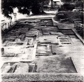
Block 28, which contains the Peyton Randolph lot, was divided into several so-called "archaeological areas" before the first excavations in the 1930s. The three areas that were re-excavated in 1982-1985—B, G, and H—are shown in Figure 4.
Although these area designations are purely arbitrary, the areas are described separately for several reasons. First, and most importantly, areas G and H appear to have been used differently during the past. Second, it is more convenient for the descriptive reporting. The 28B area is described with the 28H area, however, because of its paucity of information and its proximity to the latter area.
The following sections describe the major layers and the structural remains found in the 28G area. Measurements are given in tenths and hundredths of feet rather than in inches. This is a standard compromise with the metric system prevalent in the Tidewater area. In order to restrict the often repetitive word clutter that accompanies descriptive text, the first measurement given, for example, of a post hole, is always the north-south axis. The second measurement is the east-west axis, and the third is the depth. This is standard for the description of any feature or structural remains.
24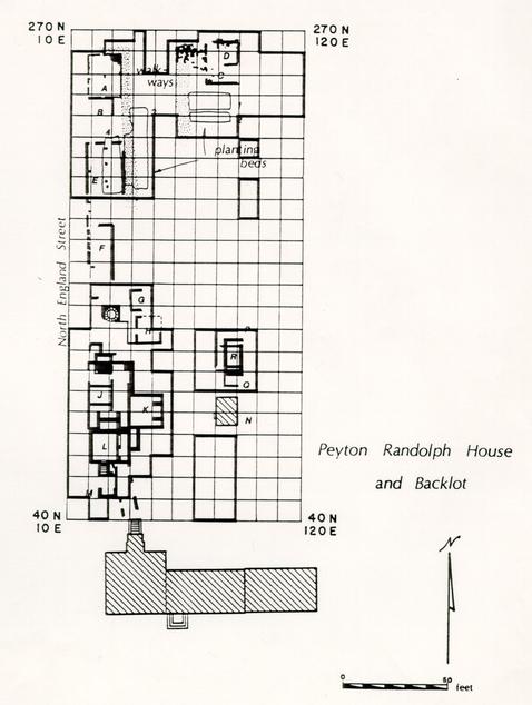 Fig. 4 - Overall Map of Excavation Area
IV.A. STRUCTURE A - EARLY EIGHTEENTH-CENTURY DWELLING
 PHOTO 5. - Structure A
Structure A was first excavated during the 1955 exploration of the Peyton Randolph back lot (Photo 5, above). It was probably a wood frame building measuring approximately 20 by 16 feet, containing a hearth in the northeastern corner. The building's sill was supported by nine brick piers. The presence of the piers was hidden from exterior view because the area between them was filled by a one-brick-wide string course. The bricks in the string course were of the same firing and size as those of the piers, so it may be assumed they were contemporary. The purpose of the "façade" of string brick was either one of aesthetics, making the building appear it was more substantial than it actually was, or one of practicality, perhaps helping keep unwanted animals from under the house. The filler bricks supported little weight since many of them were simply laid one on top of the other without benefit of mortar or the interlock needed to support a sill. The depth of the facade and piers varied from three courses in the east to five in the west. This compensated for the natural slope of the land towards North England Street, and for the continuing compaction of a seventeenth-century drainage/boundary ditch upon which Structure A had been constructed. The builders of Structure A were apparently well aware of the earlier ditch because the southwestern pier of the structure rested on a line of rowlock brick placed across the feature (Photo 6). The support brick were also the same as the building brick, evidence that they were laid before the house was built in anticipation of compaction problems.
Even though the foundations of the small structure had been previously excavated, much archaeological evidence pertaining to the construction of the building remained. A large support beam probably ran north to south under the
26
 Figure 5 - Placement of Joist Nails, Interior Structure A
27
floor through the center of the structure since three central bricks lined up in this direction. No comparable arrangement ran east to west. Impressions of the sill had been left in the wet mortar on the exterior of the chimney base. The size of the sill was surprisingly small, little more than 4.5", based on the slight elevation difference between the wall foundation and the firebox or floor level. Several rows of upright nails found in situ in the southeastern corner of Structure A suggest wooden joists approximately two feet apart with floor boards running north-south (Fig. opposite).
Figure 5 - Placement of Joist Nails, Interior Structure A
27
floor through the center of the structure since three central bricks lined up in this direction. No comparable arrangement ran east to west. Impressions of the sill had been left in the wet mortar on the exterior of the chimney base. The size of the sill was surprisingly small, little more than 4.5", based on the slight elevation difference between the wall foundation and the firebox or floor level. Several rows of upright nails found in situ in the southeastern corner of Structure A suggest wooden joists approximately two feet apart with floor boards running north-south (Fig. opposite).
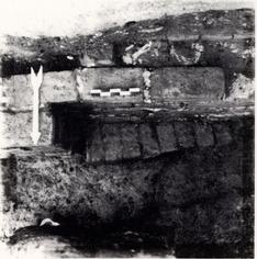 Photo 6. - Rowlock Wall Under Foundations of Structure A
The small corner fireplace (Fig. 6, below right) was contained by the north and east exterior walls of the structure. Five courses of brick remained, and while the top three were well-mortared, the bottom two were held in place by a fine sand mixed with oyster shell bits. The bottom course rested on subsoil, and extra brick were placed around it to fill the gap between the base and the walls. The fourth course from the bottom contained one brick which was mortared to the top of the northeastern pier. Sufficient area remained on top of this pier, however, for the sill to have been in place when the chimney was constructed. The possibility that the fireplace was an addition to a standing building rather than original to its construction cannot be ruled out.
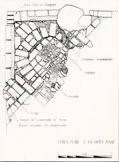 Figure 6. - Detail of Corner Fireplace, Structure A
The firebox consisted of one course of brick mortared to redeposited fill at the level of the fourth course from the bottom. The fill contained ash, plaster, mortar, and rubble, but no diagnostic artifacts. A circular area of the firebox was heavily burned, and the bricks were black, worn, and 28 crumbled. The hearth bricks in front of the firebox were mortared onto fill, and the outer or southwestern edge had fallen and slumped downward. The fill was similar to that under the firebox, containing ash, mortar, plaster and brick (only in lesser amounts). As few artifacts were found in the fireplace fill, no date was obtained for this part of the chimney feature either. However, one artifact of note was found in this fill: a manganese decorated delft tile fragment. This may indicate a repair or rebuilding of the hearth and fireplace, but more likely it was a residual artifact already in the fill and has no connection with Structure A's fireplace.
 Photo 7. - Detail of Fireplace "Wing"
Also of note were two brick pads or "wings" on either side of the chimney base (Photo 7, above). Neither of these "wings" was mortared to the chimney base, although the two remaining courses in the northwest "wing" were mortared to each other. This mortar layer and the upper course of bricks extended northward over the former sill. Impressions of what is believed to be that sill remained on the underside of the mortar. Elevations taken on these bricks indicate a sill of approximately 4.5". The other bricks of the "wing" were mortared onto redeposited fill similar in color to that found under the firebox. Again, unfortunately, no diagnostic artifacts were found. The southeast "wing" consisted of only one course, and was badly damaged by a later posthole which destroyed part of the chimney base in the same area. Neither of these "wings" was designed to bear substantial weight, for unlike the chimney base they rested on redeposited fill rather than stable subsoil. One must assume these corners to the fireplace were flooring or low shelves filling the gap in the interior between the chimney and the walls.
The demise of Structure A is illustrated in soil differences evident in a balk left standing within the interior of the structure (Fig. 7). Under the topsoil and the remnants of a 1975-76 bus turnaround, the interior of Structure A contained four major layers. The uppermost layer (28G/81) was a mixture of brick rubble, mortar, and plaster with very little soil or artifacts. The western half of this layer was excavated in 1978. The second layer (28G/88) contained a concentration of plaster as well as numerous mid-eighteenth-century artifacts. Under the plaster was a layer of dark brown and yellow loam (28G/108) [Munsell: 10YR5/6], containing numerous artifacts and some charcoal. The fourth and last stratigraphic layer, before subsoil, was a medium brown loam [Munsell: 10YR5/3], which was probably the original topsoil present when Structure A was built. Unfortunately, it contained few artifacts. Eight cross-mends between the brownish yellow loam and the plaster layer indicate they were part of a similar or the same series of events. No cross-mends were associated with the other two layers, but this was not
29
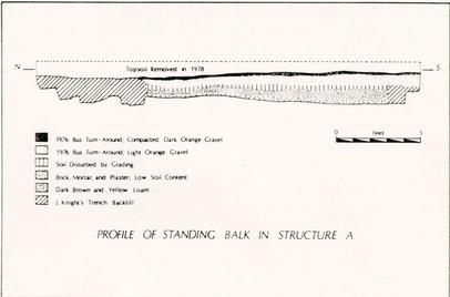 Figure 7. - Profile of Standing Balk in Structure A
unexpected since only 26 of the 434 sherds found within the structure came from the rubble and buried topsoil layers.
Figure 7. - Profile of Standing Balk in Structure A
unexpected since only 26 of the 434 sherds found within the structure came from the rubble and buried topsoil layers.
None of these layers can be physically associated with layers outside the structure since the 1955 cross-trenching followed the brick foundation walls all the way around the structure, leaving an island of undisturbed strata in the interior. The association was partially reconstructed through cross-mends. Several layers excavated outside the west wall of Structure A in 1978 contained ceramic fragments which cross-mended with the two artifact bearing layers on the interior. Figure 8 illustrates these layers, the thirty cross-mends, and reconstructed elevations. These exterior layers were described by Eric Klingelhofer in his "Interim Notes" (see Appendix 4) and include a thick mortar layer (ER2175F) sealing a half-inch deposit of brown loam (ER2175J) that contained numerous shell fragments, then another half-inch of ashy loam (ER2175K). These layers sealed a one-inch layer of loam (ER2175L) containing mortar, plaster, brickbats, and numerous fragments of delft tile. Under this tile layer was another ashy loam layer (ER2175M, N), sealing a large scatter of pipe stems (ER2179A). These pipe stems created a fairly flat surface over a two-inch layer of brown loam (ER2175T) and two deposits interpreted as the infilling of depressions in the brown loam (ER2171J and ER2175P). Below the brown loam and above natural was reportedly a three-inch layer of buff sandy loam (ER2175V).
Klingelhofer thought these layers represented the daily sweepings from Sir John Randolph's law office (pipe stem layer ER2179A), a renovation (mortar, plaster, and tile layers), a dower house for Lady Randolph (loam layers ER2175J
and K), and then demolition (mortar spread ER2175G). However, cross-mends illustrated in Figure 8 indicate that everything from the ashy loam (ER2175M) beneath the delft
30
 Figure 8 - Cross-Mends to 1955 Trench Fill, Structure A
31
tiles up to the mortar spread (ER2175G) was destruction debris. Though this was described as five layers, only two inches existed between the mortar and the ashy loam. In fact, all of these layers also cross-mended to each other (Fig. 8). This certainly supports the argument that all these layers represent one event of relatively short duration rather than renovation, use, and destruction.
Figure 8 - Cross-Mends to 1955 Trench Fill, Structure A
31
tiles up to the mortar spread (ER2175G) was destruction debris. Though this was described as five layers, only two inches existed between the mortar and the ashy loam. In fact, all of these layers also cross-mended to each other (Fig. 8). This certainly supports the argument that all these layers represent one event of relatively short duration rather than renovation, use, and destruction.
The association becomes even clearer when horizontal distributions are considered along with the vertical ones. Figure 9 combines a distribution map from the 1982 excavations with a sketch map from the 1978 excavations. The 1982 section shows the distribution of ceramics inside Structure A provenienced to 2.5-foot sub-units. The 1978 section shows the placement of two recognized artifact scatters—mortar and tiles. Taken together, they illustrate a localization of trash disposal. It would appear that after the wooden structure was removed the brick foundation stood open while dumping occurred near the south half of the west wall, both inside and outside the foundation. Perhaps this was an attempt to fill the gaping hole left by the removal of Structure A and to level the downslope west of the foundation. All this material was functioning as landfill and must have been trash from another structure, probably the main house, given the quality of the items represented. The mortar/plaster layers may represent debris generated from the construction of the mid-section of the main house. Since the point of dispersal for the debris appears to have been N. England Street near the southwestern corner of Structure A, this could indicate that a cart was used to haul in the trash from some distance away. It is thus likely that these deposits were secondary refuse and not directly relevant to the interpretation of Structure A.
The same may be true of the plaster layer inside Structure A (28G/88). Although the cross-mends seem to indicate the ceramics in the plaster layer and the layer below (28G/108) were part of the same deposit, the artifact distributions are different (Fig. 10). Artifacts were concentrated in the southwestern corner in both layers but are more densely distributed at the lower level and more spread out in the plaster. The most plausible explanation is that the lower layer was the product of actual dumping; when the plaster was added, it was raked smooth to cover and seal the derelict foundation/landfill. Spreading of the plaster dislodged and dispersed some of the trash beneath it, indicating that the plaster and the rubble may have been secondary refuse also.
With many of the layers on the exterior of Structure A excavated in 1978 now reassigned to the post-occupation period, the functional interpretation of the structure as a law office and dower house as proposed by Klingelhofer has to be rethought. The only layers excavated in 1978 that were relevant to the occupation of Structure A are the pipe stem layer (ER2179A), the two-inch layer of brown loam (ER2175T), and two deposits cutting this loam (ER2171J and 2175P). Three inches of buff sandy loam under the brown loam were excavated but few artifacts were found.
The building was occupied some time after 1720 and destroyed before 1770, probably between 1755 and 1765. The occupation layers produced a terminus post quem of 1720 based on the presence of white salt-glazed stoneware and Yorktown pottery. Three fragments of clouded ware and one of refined agate-ware were found in the debris layers. These sherds provide a TPQ of 1750, and the absence of cream-ware, popular after 1770, suggest destruction occurred before that date. This destruction date could be reduced to 1755-1765 based on mill-edged clouded ware
32
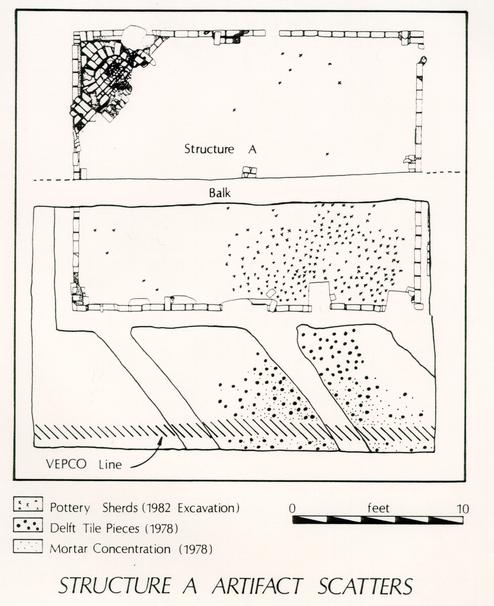 Figure 9. - Structure A, Artifact Scatters
33
Figure 9. - Structure A, Artifact Scatters
33
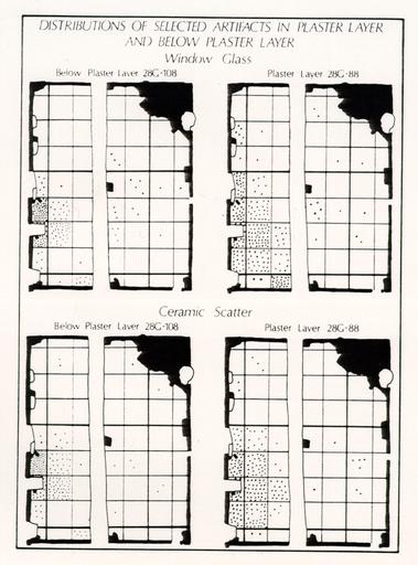 Figure 10. - Distribution of Selected Artifacts in Plaster Layer and Below Plaster Layer
34
plate fragments. According to Colonial Williamsburg's Resident Archaeologist: "Archaeological studies have so far failed to establish the presence of … the clouded glaze wares, in American homes before the mid-1750s … [Also] the milled edge seems to have been popular in the period 1755-1765" (I. Noël Hume 1970:409).
Figure 10. - Distribution of Selected Artifacts in Plaster Layer and Below Plaster Layer
34
plate fragments. According to Colonial Williamsburg's Resident Archaeologist: "Archaeological studies have so far failed to establish the presence of … the clouded glaze wares, in American homes before the mid-1750s … [Also] the milled edge seems to have been popular in the period 1755-1765" (I. Noël Hume 1970:409).
The uppermost occupation layer (ER2179A) was described by Klingelhofer as "a 1-inch thick layer of soft loam containing in some places more pipe stems than soil … small pieces of bottle glass were found among the pipe stems." It covered a "fairly flat surface presented by infilling of … depressions." It is suggested that this represents repair work on the ground in preparation for a pipe stem paving similar to the one reported by Audrey Noël Hume at the Hugh Orr dwelling, also in Williamsburg. This paving, too, was composed of fragments of clay tobacco pipes mixed with small pieces of window glass and a number of glass and ceramic items (A. Noël Hume 1963:22). Almost none of the pipe stems near Structure A show any sign of having been smoked, indicating they were probably wasters or part of a damaged shipment transported to the site for use as paving.
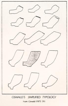 Figure 11. - Oswald's Simplified Typology
Since these items were part of a walking surface, the pipe bowls from this layer were fragmentary, but enough could be pieced together for comparison to Adrian Oswald's simplified general typology (Oswald 1975:35-38). The overall form of these bowls is most similar to Oswald's type 11 (Fig. 11), but the bases were somewhat smaller than the one illustrated. Oswald reports that bowl type 11 has a date range of c. 1730-1760 and has a base that declines in size over time. Therefore a date range for the smaller-sized bases could be narrowed to about 1740-1760.
In 1978 the Binford mean date formula was applied to the diameter of the holes in the stems. Laboratory personnel derived a mean hole diameter of 4.18 for 35 1,506 fragments, producing an extrapolated date of 1772.69. The stems were remeasured in 1983, expanding the sample to 1,789; a date of 1774.06 was determined. However, neither estimate likely represented the actual date of deposition of a layer characterized by 1740-1760 pipe bowls and sealed by several layers dating to the 1750s or 1760s. Rather than declaring Binford's formula invalid, the nature of the sample was evaluated. The sample was indeed suspect since it was probably a shipment of wasters, and was at any rate probably from the same shipment rather than the assorted domestic garbage from which the formula was derived.
The sample was also compared to those above and below it, and to the pattern established by J.C. Harrington and presented by Ivor Noël Hume in A Guide to Artifacts of Colonial America (1969a). This set of data is presented in Figure 12.
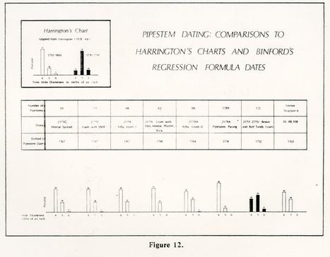 Figure 12. - Pipestem DATING Comparisons to Harrington's Charts and Binford's Regression Formula Dates
All the other samples date to the 1750s or 1760s and conform to the patterns presented by Noël Hume. In fact, even with relatively small samples, the other layers sort out in an acceptable pattern. Those predating destruction predict 1750 dates while those believed to have been deposited after demolition predict 1760 dates. Consequently, the pipe stems in the paving must represent an abnormal collection. Either the pipes were wasters and the abnormally small bore diameter relates to their status as rejects, or if they represent one shipment, perhaps
36
damaged in handling, the averaging effect of several shipments reflected in domestic garbage may be necessary for Binford's regression line formula to be applicable.
While the dating estimate based on bore diameters could not be used in this unusual case, the estimate of 1740-1760 based on bowl type seems acceptable. Destruction layers believed to date to 1755-1765 sealed the deposit, and the pipe stems overlay a portion of another deposit that may date to the 1740s. This latter deposit was described in the 1978 field notes and is believed to be the westernmost extension of the grey ash layer found in 1982 under the clay walkway bed north of Structure A. This ash contained Astbury ware, a ceramic type most popular in the 1740s (I. Noël Hume 1969b:35). The occupation layers, also beneath the pipe stem layer, contained Yorktown pottery, a type out of production by 1745.
If this stratigraphic relationship is accurate, then the pipe stem scatter may have been part of an up-grading or formalization of pathways in the 1740s or soon after. Judging from the presence of an occupation layer (ER2175T) beneath the pipe stems, Structure A must have been occupied before the addition of that paving. There is no evidence that the addition of the paving accompanied any major change in the use of the structure. Both the brown loam (ER2175T) below the pipe stems and the loam (ER2179A) surrounding the pipe stems contained few artifacts compared to the destruction layers above. Ceramic fragments totaled 141 and 130, respectively, while the secondary trash deposits above contained 2,279 fragments. These two layers (ER2175T and ER2179A) were also similar in ceramic content. Refined- to-coarseware ratios were almost identical for these two deposits, approximately 85 to 15.
 Figure 13. - Ware Types - Specific Categories
In an attempt to uncover the function of Structure A, the occupation layers were analyzed according to several criteria: specific ware type, context of use, and vessel form.
Figure 13 describes ware types according to specific categories. The counts from the destruction layer inside Structure A were also considered here for, comparative purposes. These graphs show that the occupation layers consisted mostly of delft and white salt-glazed stoneware. The destruction layer had more Chinese porcelain, and also a wide variety of types. This would probably be true of trash hauled in from the street. This secondary deposit contains a greater diversity of material since it was composed of objects discarded, perhaps from a
37
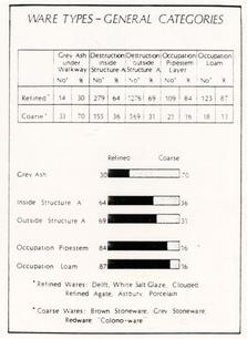 Figure 14. - Ware Types - General Categories
number of original sources. By contrast, the sparse collection from the occupation layers is the product of behavior specific to Structure A.
A summary of the various artifacts from the occupation layers is provided in Figure 14. These items are grouped according to functional categories and broader contexts of use. This perspective, modeled after Lyle Stone's Fort Michilimackinac report (1974), was taken to provide information on the specific use of Structure A.
The most plentiful artifacts in the uppermost occupation layer were pipe stems (59%) and window glass (16%). However, these were the major constituents of a paving surface and were less plentiful in other occupation layers (pipe stems 24%, glass 6%). The pipe stems showed no sign of having been smoked. Another eighteenth-century walkway uncovered in Williamsburg reportedly also contained "fragments of clay tobacco pipes mixed with small pieces of window glass" (A. Noël Hume 1963:22). Apparently in both cases, these two items did not serve their usual functions in personal and structural contexts. This fact is even more apparent if one compares percentages of artifacts by these functional categories with and without these paving materials.
| % of Artifacts: | ||
|---|---|---|
| Context of Use | Paving Layer/Remaining Occupation Layers | |
| with Paving Materials | without Paving Materials | |
| Personal | 32%/70% | 10%/14% |
| Household | 63%/10% | 89%/84% |
| Structural | 6%/20% | 1%/ 1% |
| Crafts | 0%/0% | 0%/ 1% |
As this breakdown illustrates, eliminating the paving materials from the data set brings the percentages closer together, making the two occupation layers similar in all categories.
The percentages shown in the chart represent totals for all the occupation layers minus the paving materials. This occupation material, most likely discarded or lost near its place of use, reflects an unexpected function for the building. This Peyton Randolph-period outbuilding, where one may have expected a craft or service activity to be carried out, appears, instead, to have been the site of domestic activity. In fact, less than one percent of the artifacts could be attributed to a craft, while an overwhelming 86% reflect a household context. This percentage, taken with the 13% representing personal items, implies this building was either a residence or at least a place where food and beverage consumption occurred.
Ideally, these counts should be in numbers of vessels rather than fragments. However, the material was quite fragmentary (as is usually the case with occupation layers constantly walked upon), thus accurate vessel counts were difficult to obtain. The wine bottle necks and bases sorted into a minimum of only nine bottles, and the many small ceramic sherds were mended into only seventeen vessels:
| Ware | Vessel Form | No. of Fragments |
|---|---|---|
| Colono-ware | Bowl | 1 |
| Delft | Punch bowl | 16 |
| Punch bowl | 22 | |
| Plate | 1 | |
| Plate | 4 | |
| Tankard | 1 | |
| Ointment pot | 5 | |
| Chinese porcelain | Shallow bowl | 1 |
| Plate | 1 | |
| Coarseware | Milk pan | 14 |
| Milk pan | 1 | |
| Brown-glazed earthenware | Pitcher | 2 |
| Pitcher | 2 | |
| Fulham-type stoneware | Tankard | 1 |
| White salt-glazed stoneware | Tankard | 29 |
| Tankard | 15 | |
| Teapot | 41 | |
| Teapot | 3 |
Only two of these vessels are milk pans; one is an ointment pot, the remainder are teawares or tablewares. Evidently much more food and beverage consumption took place in Structure A than food preparation, which is not surprising considering the huge kitchen complex on the lot and the small hearth within Structure A.
The identity of those participating in these activities is not at all clear. The person(s) residing in, or making use of, Structure A prior to the 1755-1765 destruction date, was apparently taking food from delftware plates and serving tea from white salt-glazed teapots. Tea drinking during the first half of the eighteenth century was relatively restricted, as the commodity itself was highly priced and teawares were not plentiful or readily available (Roth 1961:66; Shammas 1980:14). This fact, coupled with the presence of mirror glass, another expensive item during the period, suggests that those residing in or using Structure A enjoyed a social position above that of the great majority of domestic slaves, but far below that of the Randolphs themselves, whose teawares and dinnerwares at the time include a number of export porcelains, such as blue-and-white and Imari styles. If Structure A was actually lived in, the occupant could have been a tutor, craftsman, overseer, or favored slave.
In summary, Structure A remains enigmatic. The occupation layer contained no artifacts that would typify any specialized function; however, chronological questions have been answered. It was certainly demolished during Peyton Randolph's lifetime, possibly after his mother's death, and most likely between 1755 and 1765.
The artifacts and stratigraphy in and around Structure A were analyzed more intensely than those associated with any of the other structures in the Randolph lot. The reasons for this approach to the analysis of Structure A material was simply because it was the only structure excavated that contained or was associated with a significant number of artifacts that could be identified as relating to the structure and reasonably intact stratigraphy. A similar analysis of the other structures is not possible because of the relative lack of these important components. Further analysis of Structure A material, and that from other parts of the site, has been accomplished and is continuing. Such analysis is, however, beyond the scope and purpose of this descriptive report. Another report, dealing with detailed and interpretive analysis of several aspects of the Peyton Randolph archaeology, is now in progress and is scheduled for completion in 1990.
IV.B. STRUCTURE B - OUTBUILDING
 PHOTO 8. - Structure B
Located only 0.35 feet south of Structure A, though at a higher stratigraphic level, were the scant remains of a small building designated Structure B (Photo 8). The foundations were situated within units 230-240N 10-20E. The north wall was the most intact of the three remaining; it was ten feet in length, one and a half bricks wide, and constructed in English bond. The east wall was also in fairly good condition, 8.2 feet in length, also one and a half bricks wide, and constructed in English bond. The south wall was completely robbed, probably in the mid-nineteenth century. However, a row of seven bricks, laid flat and oriented north-south, was found along the exterior of the south wall's original location. These bricks may represent the remains of steps leading to a door on the south side of the structure. Only what seems now to be a pier remained of the southwestern corner of the building. This pier was three courses high, of indeterminate bond, and measured 1.6 feet north-south and 1.3 feet east-west. No traces of the west wall, save the southwestern corner, remained. Exterior dimensions of the small structure were eight feet north-south by ten feet east-west. Interior measurements were 5.4 feet by 7.8 feet.
The building was first uncovered during the 1955 excavations, with the exception of the southwestern corner, which was missed by the cross-trenches. At that time a 3.6 foot square brick appendage was centered along the north wall of the structure (Fig. 15). The appendage rested on fill above the foundation wall of nearby Structure A. Although the appendage appears on the Knight Map and seems to be a small chimney base, no traces of it survived the construction of the bus
42
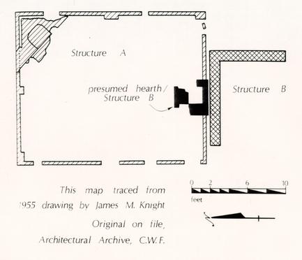 Figure 15. - Brick Feature over South Wall of Structure A (from J.M.K. map)
turnaround in 1975. Knight coded the structure as "second period colonial" on his overall map, but coded the appendage as "third period." The appendage was necessarily constructed after the demise of Structure A (c. 1760). Structure B itself, however, may have been built while "A" was yet standing, although this is unclear since no builder's trenches which could closely date Structure B's construction were left intact after the 1955 excavations.
Structure B was constructed on the Brown Sandy Loam 2 (BSL 2) layer of sheet refuse which built up over the 1720 to 1800 period. The southwestern corner of the structure, previously undisturbed by the 1955 excavations, was sealed by Brown Sandy Loam 1, the sheet refuse layer which followed BSL 2 and which was deposited primarily in the first half of the nineteenth century. A layer of rubble and plaster (28G/ 1752) within the interior of the structure could represent the destruction of the building. This rubble has a TPQ of 1820. Given this evidence, it appears that the building was probably constructed in the third quarter of the eighteenth century and survived until the second quarter of the nineteenth.
43The function of Structure B is not easily determined. The predominant artifact type within the structure was bone. Two fully articulated bird skeletons (a duck and a rooster) were excavated from the interior (Photos 9 and 10). However, these animals may have been yard fowl that hid in the building and subsequently died, revealing nothing about the actual function of the structure. The structure and associated layers were so highly disturbed in this area that little other than a description of the building as it existed when found can be reported upon with any certainty.
 Photo 9 - Articulated Remains of Rooster
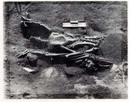 Photo 10 - Articulated Remains of Duck
IV.C. STRUCTURE C - OUTBUILDING
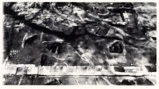 PHOTO 11. - Structures C and D
In the northeastern section of the 28G area, in units 250-70N 70-80E, the foundations of two structures were located (Photo 11, above). The larger and later of these two was Structure C. Structure C's foundations measured twenty feet north-south by sixteen feet east-west. As with most other Williamsburg buildings, the foundations were oriented on the north-south, east-west axis. The strata associated with Structure C were highly disturbed by various activities in and around this area, especially on the interior of the building.
The interpretation of the surrounding strata was complicated by strata associated with the earlier Structure D underlying the area, and by overlying layers and features associated with three major occurrences. The first of these was the plowing of the 28G area during the mid-nineteenth century. This resulted not only in the disruption of the area's stratigraphy by the act of plowing itself, but in a systematic redistribution of bricks from various other locations. In this instance, the bricks were moved from an area being plowed to an area which was not being plowed, i.e., the area around the then-newly-planted pecan trees. The trees themselves were disrupting agents, as the roots from the easternmost tree caused a substantial amount of damage to the western walls of both Structures C and D, and also damaged the northern walls. The roots and the trees made excavation of the area impractical and destroyed a large amount of the stratigraphic record relating to the structures. Lastly, cross-trenching undertaken throughout 28G in 1955, and the subsequent uncovering of the brick foundations by the excavations, interrupted the stratigraphic connections between interior and exterior as well as destroying almost all of the builder's trenches.
In combination, these disruptions caused a serious clouding of the stratigraphic relationships in the area, making determinations of function and period of use much more difficult than they otherwise would have been. Fortunately, enough of the stratigraphic record remained to make some strong correlations.
The foundation remnants of Structure C's four walls present an intriguing picture because none of them match. The northern wall was composed, for the 45 most part, of stretchers made from brick bats. The western wall had headers along most of the wall along with nine rowlocks at the north end. The east wall was made up of headers. Only the south wall appears to have been constructed with workmanship in mind. This southern foundation which was constructed in English bond and was the wall facing the main house.
A small amount of hard-packed marl in 260-70N 80E, measuring about 0.2-0.3 feet in depth, was probably all that remained of the floor to Structure C. The marl was found under the destruction layer of Structure C, and was above the destruction layers of Structure D and Brown Sandy Loam 2. As there are no other reasons for a layer of this type in this location it would seem this marl was once a part of the floor to Structure C. Among the artifacts found in the marl were white salt-glazed stoneware, slipware, and blue underglazed Chinese export porcelain.
The major occupation layer with which Structure C was associated is Brown Sandy Loam 1, a sheet refuse layer that dates from about 1775 to the mid-nineteenth century. (Please refer to section IV.J. of this report for a detailed discussion of this layer.)
A combination builder's/robber's trench remained along the northern wall of Structure C. This trench was probably used to rob bricks from the north and east walls of Structure D as Structure C was being constructed. This trench was sealed by a thin layer of marl and filled with brick rubble. After removal of Structure C's walls, excavation uncovered a fragment of pearlware, thus placing the construction date of Structure C to post-1779. This suggests that Structure C was most probably constructed under the ownership of Joseph Hornsby (1783-1800).
There is no hard evidence available to aid in the determination of the structure's specific function. It would seem, however, that Structure C was a storage building of some sort. This conclusion is due in part to the relationship of Structure C to Walkway # 2. Walkway # 2 undoubtedly serviced Structure C, evidenced by the brick paving left unplowed between the two pecan trees. The substantial nature of Walkway # 2, which is similar in this respect to Walkway # 1 (both discussed in detail in another chapter), shows that it could accommodate carts and wagons as well as foot traffic. It is probably safe to conclude that Structure C's function may have been that of a storage building which may have needed servicing by just such a passage. The artifactual and structural remains give no indication of Structure C's use as a smokehouse, dairy or other service building.
Structure C fell out of use at or just before the mid-nineteenth century, when the area was brought under the plow. A large number of nails were found about the perimeter of the building. This, along with the lack of consistency and stability of the foundations, makes it virtually certain that Structure C was a wood frame building.
IV.D. STRUCTURE D - OUTBUILDING FOR STRUCTURE A
 PHOTO 12. - Structure D
Structure D was located inside and below the remains of Structure C, principally in units 260-270N 80E. The foundation remains of the structure give the impression of a small, humble building, measuring 12.25 feet north-south by 11 feet east-west on the customary Williamsburg orientation axis (Photo 12, above). The four walls were all of a rather disjointed nature. The north wall, lying under the north wall of Structure C, was apparently partially robbed or destroyed during the construction of the latter building. The western wall was not excavated during the 1950s (or during the current excavations) because of its proximity to the easternmost pecan tree on the back lot. The eastern wall was a virtual farrago of bricks, brick bats, and mortar from both Structures C and D. The south wall was the only one of the four that was not highly disturbed, even though the western portion of this wall had been removed at some point, probably also during the construction of Structure C. All four walls of Structure D were constructed almost exclusively of brick bats, with the few whole brick used mostly as stretchers. There was nothing remotely resembling any type of bonding style in any of the walls, as the reused brick in the foundation had simply been mortared together with shell mortar.
Structure D was first excavated in 1955 during the cross-trenching carried out in the area. This cross-trenching resulted in removal of all the builder's trenches and all but one of the robber's trenches. The plowing of the area affected Structure D just as it did Structure C, disrupting the strata and causing a redistribution of a large quantity of brick into the area.
No remains of an above-ground floor for Structure D were found. However, what appears to have been a "living surface" was isolated in the interior of the 47 structure. This living surface was composed of three lenses, found only inside the foundations, and part of a major layer which was encountered in both the interior and exterior of the structure. The uppermost of these three components was a charcoal and brick layer which was located immediately under the destruction layers of Structure D and was, in fact, mingled with them. The brick in this layer was probably a result of the mixing. The soil matrix was a dark brown sandy loam [Munsell: 10YR4/3] with heavy charcoal scatter. Some of the artifacts removed from this layer date as late as the first half of the nineteenth century, but their presence was probably a result of destruction activity intruding into this charcoal layer. Other, more representative ceramics recovered from the layer included slipware, white salt-glazed stoneware and North Devon gravel coarseware.
The next level of the living surface was composed of a brown layer [Munsell: 10YR5/3] and a dark yellowish brown layer [Munsell: 10YR4/6], both found only within the interior of Structure D. The brown layer contained several different artifact types, all of which dated to the early part of the eighteenth century. These included Westerwald stoneware, Colono-ware, white salt-glazed stoneware, various coarsewares, slipwares, and black-glazed redware. There were no artifacts found in the darker layer.
The remaining layers (those lying below the so-called living surface) were all stratigraphically below Structure D with the exception of Brown Sandy Loam # 2. The BSL 2 layer occurred both in the interior and the exterior of Structure D. It was, however, much thinner on the interior of the building than on the exterior. This thin lens of BSL 2 seems to represent deposition prior to the construction of the building. The remaining, thicker exterior deposition of BSL 2 corresponds to the occupation of Structure D.
A great deal of the interpretation of Structure D depends upon the stratigraphic relationships of the various soils. From a comparison of the layers on the interior and exterior it is fairly easy to determine the way in which the layers associate with the various phases of the building (construction, use, and destruction). The construction of Structure D took place after BSL 2 began to be deposited but before the deposition was complete, evidenced by the thin layer of BSL 2 in the interior and the thicker build-up on the exterior. BSL 2, a sheet refuse layer, was first deposited about the time of the major development of the property in the second decade of the eighteenth century. Structure D was probably constructed shortly afterward. The layer best related to the occupation of Structure D was this same Brown Sandy Loam 2. BSL 2 extended over most of 28G and was the lowest stratigraphic layer found in the area. The layer of sheet refuse was the predominant cultural stratum on the whole site from about 1720 to the end of the century (see Chapter IV.J.)
The destruction layers relating to Structure D were of various types, the common denominator being brick rubble. A sizable portion of this brick rubble probably resulted from the numerous disruptions in the area. However, as some of this rubble was directly sealed under the marl floor to Structure C, it is safe to assume that this rubble came from the razing or falling of Structure D. The layers most closely associated with this destruction activity also contained a vast quantity of "destruction-type" debris such as mortar, nails, window glass, etc. These layers also contained ceramics which were helpful in dating the destruction event. Included among these ceramics were agateware and creamware. The presence of 48 creamware indicates that Structure D could not have been torn down prior to 1762, when creamware was introduced.
With the exception of one possibly intrusive sherd of Bennington ware, there were no artifacts of a later date. The lack of later artifacts leads to the assumption that Structure D was probably torn down in the 1760s or 1770s, and certainly before the building of Structure C.
The ash content of the soils on the interior of Structure D seems to indicate that the building may have functioned as a smokehouse. The dimensions and the meagerness foundations of the structure indicate that it was wood framed; a large quantity of nails found around the perimeter tends to substantiate this interpretation.
In summary, Structure D was probably a wood-framed service building, possibly a smokehouse, which stood for approximately fifty years between the 1720s and the 1760s or 1770s when a major re-orientation of the back yard occurred. This re-orientation was based on the construction of the mid-section of the main house and the subsequent construction of Structures C, E, and F, as well as the re-building of walkways to service them.
IV.E. STRUCTURE E - GRANARY (?)
 PHOTO 13. - Structure E
Structure E is located 21 feet south of the south wall of Structure A (Photo 13, above). The building was almost totally excavated in the 1955 archaeological investigation, with only a five-foot segment of the east wall being inaccessible at the time. Most of the structure was again excavated in 1984, with the exception of the southern quarter, which was left untouched because of its proximity to the access driveway for the Randolph House life-tenant and the presence of a large walnut tree.
In its entirety, the building measures approximately 28.5 feet and 18.5 feet. Only the east, north, and west walls were uncovered; the south wall (if still intact) remains located under the access drive. None of the three walls uncovered bore any resemblance to one another. The east wall appeared to be the earliest of the three; nineteen feet of it was excavated in 1984. The wall was a brick and a half in width, set in English bond, and fairly well-constructed out of principally whole, previously-unused brick. The northeastern corner had been destroyed, making the relationship between it and the north wall somewhat ambiguous. The north wall was only one brick wide, one course deep and truncated in several places by subsequent disturbances in the area. No particular bonding style was recognizable in the remains.
The west wall was obviously built much later than either the east or north walls. It was only one brick wide, consisted of mostly used brick bats, poorly 50 constructed (not even straight), and casually bonded with sand mortar. The west wall was constructed over the north wall at the northwestern corner.
In addition to the walls, the building contained a series of piers running down the, center the length of the structure. Three piers were located, and another virtually destroyed, by cross-trenches during the 1955 excavations. Three others were found during the 1984 excavation. The piers were constructed on 2.5 foot centers and composed of new brick with shell mortar. Fill around one of the piers had a TPQ of 1779. This TPQ ties in closely with the underpinning of the "Granary" by Humphrey Harwood in August, 1785 (see Appendix 2). If these piers do represent the work of Mr. Harwood on that date, the function of the building during that period is established historically.
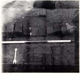 Photo 14. - Detail of Collapsed Pier, Structure E
In addition to having been underpinned, the building was later partitioned in the center from east to west. Two short appendages were constructed at right angles abutting the interior of the east and west walls at the center of the building. An east-west 3.5 by 0.7 foot pier was also constructed in the center of the interior, either to partition the building into two equal halves, or to brace the center of the floor. Whatever the case, the center pier obviously bore considerable weight as it was actually pushed into the ground several inches (Photo 14, above). The weight was concentrated in the center of the pier as if from a support beam which ran north-south down the middle of the structure, rather than east-west across it. The two short corresponding appendages attached to the east and west walls show no evidence of excessive weight from the floor above.
51With the function of Structure E possibly established as a granary, the temporal span of the building's use can be addressed. The older east wall and the center piers for Structure E were built on Brown Sandy Loam 2, a sheet refuse-bearing layer which was deposited over a long period of time during the eighteenth century. Planting Bed 4 was also located under the foundation walls and brick piers. This planting bed was probably in use up until the fifth decade of the eighteenth century. No compaction into the planting bed fill was exhibited in the foundation wall or piers to the structure, indicating the bed had some time to stabilize before Structure E was erected. If it is assumed that Structure E is the granary referenced in Harwood's ledger, then the building had been standing long enough in 1785 to require repairs. Allowing ten years for compaction and ten years for deterioration, it may be conjectured that the structure was built between 1750 and 1775. The clay base to what appears to be a work area around the structure has a TPQ date of 1762, conforming to the proposed construction date.
All of the north, east, and west walls, as well as most of the piers, had to be removed in order to excavate Planting Bed 4. Removal of the west wall revealed several post holes directly under the wall which appear to be a continuation of a long-standing north-south fence line at the western edge of the property. The fence was probably maintained even after the west wall for Structure E was constructed. This is evidenced by the observation that other post holes associated with the many repairs to the fence line are more numerous and often have later TPQ dates than the post holes under the west wall. The original west wall of Structure E many have been of post construction, as no evidence of a brick wall previous to the one which remained was found. In any case, the west wall of the structure seems to have always been used as part of the western fence line. (For a more detailed discussion of this fence line, refer to Chapter V.N. of this report.) Soil excavated from under the west wall of the structure contained one fragment of whiteware, producing a TPQ of 1820, thus suggesting that the west wall must have been constructed after this date. Unfortunately, none of the artifacts removed from under the east wall could reveal a more precise TPQ than "eighteenth century." Soil under the north wall, however, did contain pearlware (1779) as the latest datable artifact.
The demolition date of Structure E is based on several events occurring in the immediate area around the building. A post hole (28G/ 1290) which was part of a nineteenth-century east-to-west fence line separating the plowed area to the north from the yard area to the south intruded the east wall of the structure. This post hole had a TPQ date of 1880. In addition, plowing in the 28G area is thought to have been started around 1860, possibly in response to shortages caused by the Civil War. Most of the northern half of the area formerly occupied by Structure E was plowed. In all likelihood, the often repaired, ill-constructed building was demolished or fell down some years earlier.
52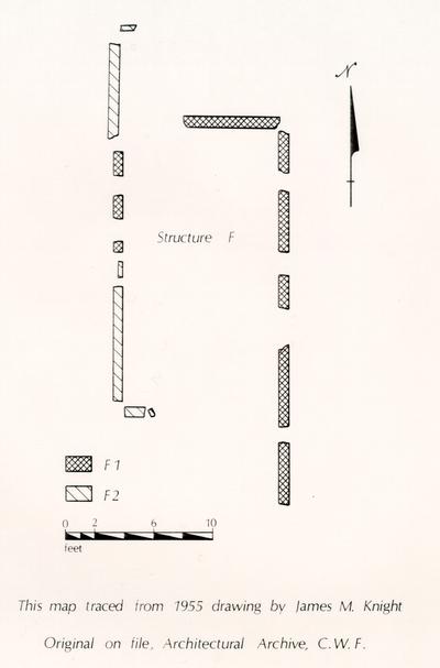 Figure 16. - Structure F (from J.M.K. map)
IV.F. STRUCTURE F - UNIDENTIFIED BUILDING
The brick walls designated "Structure F" were not investigated in the 1982-1985 excavations. The structure (or structures) were located under the access driveway, prohibiting the excavation of the area without the expense of relocating the life-tenant's access drive (Fig. 16). All that is known of the brickwork is derived from the Knight map of the 28G area, cross-trenched in 1955. This map depicts brickwork from two different periods: "colonial" (first period of construction) and "modern" (fourth period of construction).
The depicted colonial brickwork suggests a building at least 24 feet north-south and 12 feet east-west.1 Though fragmented into five pieces, the east wall was more intact than the west, of which only three short sections in the northwestern quadrant of the structure still existed. No intact corners were located in the cross-trenching. The colonial period walls were in English bond with shell mortar, approximately 0.8 feet in width.
The so-called "modern" brickwork indicates a structure approximately 26.5 feet north-south. Only parts of the west wall existed, so the width of the building is unknown. Knight coded the west wall of Structure E "modern" as well, and upon re-excavation this wall was deemed to date to the mid-nineteenth century. It is likely, therefore, that the west walls of both E and F were contemporary.
Unlike Structure E, Structure F was probably actually two separate buildings. Structure F-1, the older of the two, was located about six feet further south than the more recent Structure F-2. It is possible that the second structure shared the east wall with the first, but this can only be substantiated through an archaeological excavation of the area.
Though totally conjectural, Structure F could be the lumber house mentioned in Peyton Randolph's probate inventory (see Appendix 1).
IV.G. TOPSOIL
A grey-brown sandy humic topsoil [Munsell: 10YR5/2] lay below the sod in the 28G area, sealing the entire site. No structures or features were visible from the ground surface, and though the area grades slightly from east to west, little or no erosion appears to have taken place in recent years. Thickness of the topsoil varied from 0.15 feet in the east to 0.75 feet in the west. Artifacts recovered from the topsoil layer range from modern plastics and foil wrappers to residual finds from the eighteenth and nineteenth centuries.
 Figure 17. - South Wall - 1982 Excavation Area
Evidence suggests this topsoil layer was brought from another area and deposited over the site, probably after 1972. The section (Fig. 17) along the southern edge of the 1982 excavation area indicates three layers of fill occurring after the James Knight cross-trenching in 1955. One is a topsoil layer approximately 0.1 foot thick covering the trench fill; a second is a clayey orange layer which is believed to be the driveway of the Miller House, occupied in 1958 (see Photo 15). This drive was probably used until the house was removed in 1972, apparently after which nearly half a foot of topsoil was dumped and graded over the site. The depth of deposition of this secondary fill was less in the northern section of the site, away from the Miller foundations, suggesting Colonial Williamsburg's Landscape Department felt less fill was needed there to level out the property. Neil Black, miller at the nearby Windmill, remembers fill dirt being trucked in for this purpose (see Oral History, Appendix 7, by A.K. Foster). 55 Apparently the process was repeated after the 1975-76 bus turnaround was discontinued as a great deal of topsoil was found over this area. All of these modern sub-strata were given the topsoil designation and context numbers.
Two important conclusions can be reached after the examination of the topsoil. The first is that most of this soil was brought in during the past fifteen years, and is thus totally unrelated to the use of this lot in the eighteenth century. The second is the obvious alteration of the landscape in the area by the successive infilling, which must be a consideration when reconstruction takes place.
 Photo 15. - Miller, Skillman, and Donegan Houses
MODERN DISTURBANCES
The integrity of the topsoil layer in the 28G area had been interrupted several times in the recent past by utility lines, archaeological cross-trenching, rodent burrows, tree removal, construction and destruction of twentieth-century buildings, and the construction of a gravel bus turnaround for Colonial Williamsburg tour buses. The archaeological cross-trenching is discussed in detail by Derry and Brown (1987) in a paper entitled "Excavation at Colonial Williamsburg Thirty Years Ago: An Archeological Analysis of Cross-Trenching Behind the Peyton Randolph Site."
The bus turnaround was constructed in 1975 to accommodate the increase in visitation to Colonial Williamsburg during the country's Bicentennial celebration. It consisted of two layers, a top layer of dark orange clayey sand which was extremely hard packed, presumably from having been continually compacted by the Colonial Williamsburg buses. The second layer was a lighter orange layer of sand, pebbles, and marl, equally well packed. Varying little in depth, the turnaround layers were 0.8' deep at their deepest point. At all points under the turnaround was a layer of very dark brown, disturbed humic soil which apparently represents the mechanical grading for the paved surface. This layer contained artifacts from the last three centuries, as well as brick rubble, mortar fragments, and oyster shell. It varied in thickness from 0.1 to 0.4 feet.
The construction of the turnaround caused significant damage to at least one area of the site. Photographs and a drawing made during the 1955 cross-trenching exercise indicate the presence of a hearth or some sort of brick feature overlapping the south wall of Structure A (see Fig. 15). The small feature was probably associated with adjacent and later Structure B, but the function of the feature will remain a mystery.
Two telephone cables traversed the site from the northwestern corner near Structure A to the southern extent of excavation. The northern cable predated the 1955 cross-trenching, while the southern cable post-dated this work. Both lines apparently serviced the Miller House, which stood on the site until 1972. The cable trenches intruded the plowzone layer below topsoil, planted at a depth of about one foot. Both cables lay across the hearth of Structure A, but left the feature unscathed. The trenches for the telephone lines were not visible in the topsoil layer at the southern end of the site, indicating a very recent deposition of this layer.
Two lightning rod cables also intruded the topsoil layer on the northern end of the site. One of the two large pecan trees on the site had been - damaged by lightning in the 1960s (Neil Black, personal communication), so one may assume the grounded cables were attached some time after that occurrence. According to Klingelhofer (1978), one of the cables was moved north during the 1978 excavations in the area. Neither of the cables were evident in the photographs from the 1955 cross-trenching. Fortunately, the trenches for the cables were only dug to a depth of several inches and were no threat to any features below topsoil. The trench 57 features were excavated separately from the surrounding topsoil, but were given the provenience of the topsoil layer through which they cut.
Another, deeper trench skirted the western edge of the excavation area. This trench is much deeper (c. 2.0') and contained an in-service electric cable. Though the trench was excavated, the cable was covered and avoided throughout the archaeological process.
Along the northern edge of the excavated area, a trench-like disturbance running east to west was uncovered. The boundary delineation of the feature was distinct, but wavy. The fill was a grey sandy humus approximately 0.2 feet in depth. Photographs from the 1950s indicate a hedge in this area between the Miller and Donnegan houses. Artifacts recovered from the trench were of twentieth-century origin. The only other significant modern intrusion in the 28G excavation area was an electric service line which supplied power to the Miller House. The line was no longer "live" and was therefore removed when excavated. The line was of the old wrapped-lead variety about one inch in diameter. The trench was apparently hand-dug, approximately 1.5' deep and about a foot wide. It ran from the western edge of excavation between Structures B and E eastward through Planting Bed 3, into the southeastern extent of excavation just south of Planting Bed 2.
IV.H. PLOWZONE
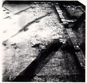 PHOTO 16. - Post Hole Through East Wall, Structure E
This very dark greyish brown mixture of sand and silt [Munsell: 10YR3/2] was the first major layer uncovered in the 28G area that was formed in situ. The layer contained brick crumbs, mortar bits, and small artifact fragments. The artifacts were not found resting on a flat surface, but were oriented randomly throughout the stratum. Plowzone consistently covered Structure A, Structure B, parts of Structures C and E, the two walkways and occupation layers with approximately 0.7 feet of soil, except in those areas disturbed during or after the 1955 trenching. Near the 90 feet east grid line, this very dark greyish brown soil thinned to 0.5 feet, and even less further to the east. The northern extent of the plowzone was not encountered during the 1982-85 excavations and it is likely that the several acres of land lying to the north of the excavation area were also under cultivation in the nineteenth century. The western extent of the plowzone was apparently North England Street. The eastern extent was not found, though it probably did not extend into the ravine where the Colonial Parkway now exists. The southern boundary of plowzone was located during the excavation of Structure E. An east-west fence line, discussed in more detail elsewhere in this report, was uncovered along the 208 North grid line. One of the postholes for the fence was dug though the east wall of Structure E (Photo 16, above). Plowzone was found north of this fence line but not south of it.
Within the plowed area, an "island" of unplowed ground was found around and between the two large pecan trees on the back lot. The base of the easternmost pecan tree was encircled by a pile of brickbats. This may indicate that the 59 gardener sensibly did not plow near the trees and piled the brick fragments struck by his plow around the base of the tree to avoid hitting them again in subsequent plowing. The brick paving at the northern extent of Walkway # 2 lies between the two trees and was not disturbed by the plowing. Further south, the walkway showed signs of scars left by the plowshares.
Plowzone was excavated in 2.5 foot square sub-units for greater detail in artifact distributions. Distributions of several ceramic types revealed the following general patterns. English delft and white salt-glazed stoneware were most prevalent in the area over Planting Beds 1, 2, and 3, and in the Structure A area. Distributions of creamware and pearlware showed a concentration around the Structure C and D area not exhibited by the delft and white salt-glazed distributions. This may be illustrative of the shift in the use of the back lot after the re-orientation associated with the building of the mid-section onto the main house.
An extremely high concentration of beverage bottle glass was revealed over Planting Beds 1 and 2, indicating that at least some of the paving or fill in the beds was affected by the plow.
Plowzone did not extend into the 28H area.
IV.J. BROWN SANDY LOAM 1 AND 2
The term "sheet refuse" has been used in recent years (Moir 1982) to describe the layers of soil and accompanying artifacts that become deposited and dispersed over a large area during the course of site occupation. This layer of refuse is of two types. The broader definition, used by Deetz (1977) and Moir (1982), describes the conscious or "quick time" disposal of trash from windows and doorways into the surrounding yard. The edible portion of this refuse would be consumed by domestic animals while the non-edible artifacts would be subsequently dispersed by human and animal activity. "Sheet refuse" in reference to the Brown Sandy Loam layers) which developed in the 28G area at Peyton Randolph refers to more unintentional accumulation of soil and domestic debris building up over more than a century. This type of "sheet refuse," described by Moir (1982), is decidedly different from that discussed by Deetz. This unintentional dispersal of trash would probably extend over a broader area and contain a wider temporal range of artifacts. The two types of "sheet refuse," however, will have similar distributional characteristics near dwellings and service buildings and may be similar in sherd size, both having been subjected to trampling.
Deetz (1977) found that the intentional discarding of debris out of doors and windows was discontinued, at least in the New England region, by the mid-eighteenth century. This "pitch-it-out-the-window" approach to trash disposal gave way to a more systematic, sanitary, Georgian method of ridding the home of unwanted debris—the trash pit. There was, of course, a concurrent and long-standing alternative method, the unintentional disposal of trash represented at Peyton Randolph. No trash pits or privies were found during the excavations, save the infilling of Structure A's foundations after the removal of the framing which did occur around mid-century. There appear, however, to be some spatial dimensions to refuse disposal. The Brown Sandy Loam "sheet refuse" (BSL 1 and 2) was found only in the 28G area, nearly 150 feet north of the main structure. The build-up began in the early eighteenth century and continued until the area was plowed in the mid-nineteenth. The 28H area, on the other hand, does not contain a "sheet refuse" layer; domestic debris was confined to features and externally-originating fill. The area was apparently kept clean.
Brown Sandy Loam 1 (BSL 1) was that part of the "sheet refuse" layer that built up during the late eighteenth and early nineteenth centuries. The plowzone layer, directly above BSL 1, was probably comprised of the top several inches of the layer, along with debris which continued to be deposited while the area was plowed. BSL 1 covered the entire 28G area west of the eastern north-south fence line dividing lots 237 and 207. It was not found on lot 237. Plowzone was directly over subsoil in this area.
The BSL 1 layer between the eastern fence line and Walkway # 2 was the subject of a spatial recording experiment carried out in the spring of 1983. The object of the experiment was to determine the most efficient size excavation unit, one which would render acceptable and accurate artifact distributions, and yet could be excavated quickly and easily. The area involved was piece-plotted,2 the most 61 exact recovery technique possible although extremely time-consuming. The piece-plotted data was then entered into a mainframe computer at the College of William and Mary where, using SASPLOT, several graphic representations of the distribution of various artifacts were produced (Figs. 18-21). Figure 18 shows the piece-plotted data as collected, with each artifact receiving a mark. Figure 19 shows the same data indicating distribution by 2.5 foot square sub-units, while Figures 20 and 21 show the same data distributed by five-foot squares and ten-foot squares, respectively. As expected, the data became less informative as the excavation unit size increased. The 2.5 foot square sub-unit seems to be the most efficient excavation unit which would render acceptable distributional results. Some information was lost, however. For example, the distribution of nails along the eastern edge of Structure D is slightly misrepresented when combined into sub-units rather than piece-plotted (see Figs. 18 and 19). A 2.5 by 2.5 foot sub-unit can be, however, excavated and screened quickly by one excavator. Notes taken at the time of the experiment indicate that while it required one person approximately a day and a half to piece-plot a sub-unit, the same excavator could shovel and screen two or three similar sub-units in one day. The loss of detailed information was not acute enough to adopt the piece-plotting approach in other areas.
Brown Sandy Loam 2 was that part of the sheet refuse layer which began deposition with the earliest occupation of the site and continued until the third or fourth quarter of the eighteenth century with the construction of Walkway # 2. Similar to BSL 1, BSL 2 existed only west of the north-south fence line separating lots 207 and 237. The layer was also found buried beneath the redeposited subsoil bases to both walkways in the 28G area. Since the experiment described above had been conducted earlier, BSL 2 was excavated only in 2.5 foot square sub-units.
It is not known how far either of the sheet refuse layers extended north of the excavated area. The only archaeology done beyond the 1980s excavation boundary was the 1950s cross-trenching, which was primarily concerned with locating brick foundations and the site of William Robertson's windmill. Although stratigraphy was recognized at the time, it was often not recorded, reported, or analyzed. The exact southern edge of the "sheet refuse" is not known either. In the thirty feet of unexcavated area between the edges of excavation in 28G and 28H, the Brown Sandy Loams cease to exist. It appears that the part of the yard between Structures F and G may have been the mental, and possibly the physical, demarcation of that which was perceived as the "back lot" as opposed to the "back yard." The "back yard" appears to have been that area directly behind the main house that was kept clean. It was also the area in which most, if not all, of the food preparation took place. Contained within this "back yard" was the kitchen, smokehouse, dairy, and well in addition to living quarters for the servants. The "back lot" buildings, however, appear to be principally storage facilities with the exception of Structure A, a dwelling with its own occupation layers.
Distributions of artifacts within BSL 1 and 2 are illustrated in Figures 22 through 44. The distributional maps were derived from data collected in 2.5 foot square sub-units using Statistical Analysis System Graphics (SASGRAPHS) installed on the mainframe computer at the College of William and Mary Computer Center.
62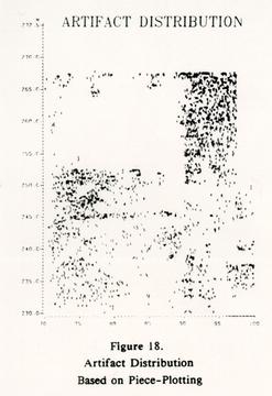 GRAPH - Figure 18.
Artifact Distribution Based on Piece-Plotting
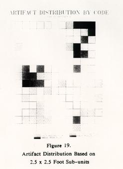 GRAPH - Figure 19.
Artifact Distribution Based on 2.5 x 2.5 Foot Sub-units
 GRAPH - Figure 20.
Artifact Distribution Based on 5 x 5 Foot Units
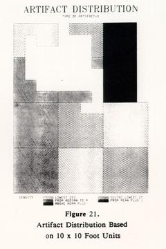 GRAPH - Figure 21.
Artifact Distribution Based on 10 x 10 Foot Units
BSL 2 (Figs. 22-30)
All distributions show similar areas of concentration: in and around Structure E, south of the eastern pecan tree, south of Structures C and D and over Planting Beds 1 and 2. There were few finds in the area of Walkway # 1 because the depth to which the area was dug in order to construct the subsoil base destroyed the earlier layer.
Only one concentration is unusual, that south of the eastern pecan tree east of Walkway # 1. The high concentration of all artifact types was noted at the time of excavation. It may be interpreted as a short-term deposit of refuse from Structure A or, more likely, an indication of the presence of another, undiscovered building just to the north. Unfortunately, the presence of the large pecan tree prevented exploration of the area to the north.
BSL 1 (Figs. 31-44)
BSL 1 distributions show similar patterning to those of BSL 2 south of the eastern pecan tree. The indication of a larger concentration of coarsewares than refined wares near Structures C and D may allude to the function of the structures as service buildings. Higher percentages of whiteware just to the south of Structure C can be interpreted as relating to the temporal aspect of the structure, which is later than any of the others in the area. The tablewares in association with Structure A may relate to its function as a dwelling.
The obvious blank space between the two walkways indicating "No Finds" is difficult to interpret. However, it may reflect a use differentiation between the eastern part of the yard, serviced by Walkway # 2 and the western, serviced by Walkway # 1. The sheet refuse layer was definitely found in the area, but artifacts were virtually non-existent.
 GRAPH - Figure 22
ARTIFACT DISTRIBUTION
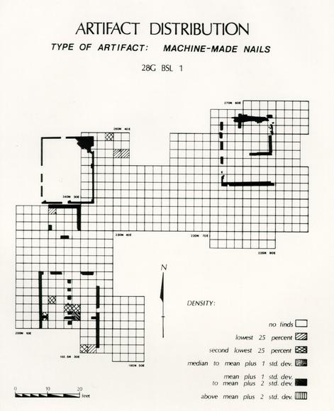 GRAPH - Figure 23
ARTIFACT DISTRIBUTION
TYPE OF ARTIFACT: MACHINE-MADE NAILS
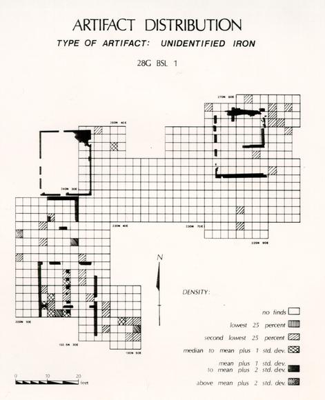 GRAPH - Figure 24
ARTIFACT DISTRIBUTION
GRAPH - Figure 25
ARTIFACT DISTRIBUTION
TYPE OF ARTIFACT: UNIDENTIFIED IRON
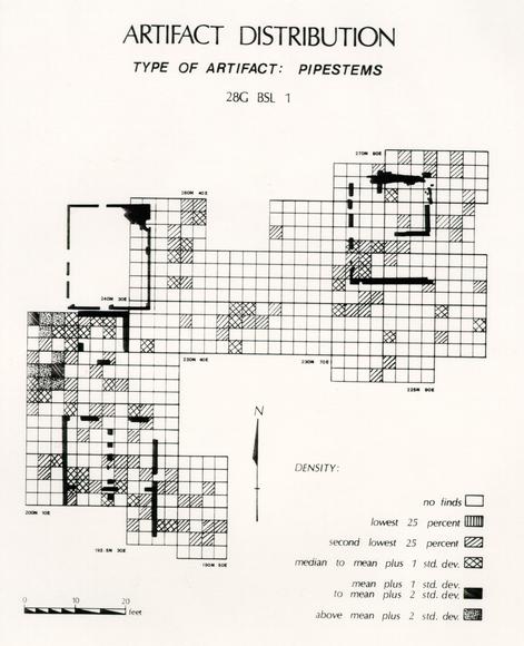 GRAPH - Figure 26
ARTIFACT DISTRIBUTION
TYPE OF ARTIFACT: PIPESTEMS
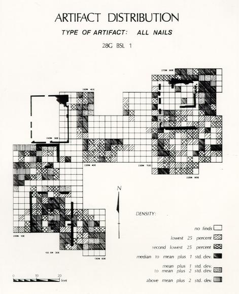 GRAPH - Figure 27
ARTIFACT DISTRIBUTION
TYPE OF ARTIFACT: ALL NAILS
 GRAPH - Figure 28
ARTIFACT DISTRIBUTION
TYPE OF ARTIFACT: WROUGHT NAILS
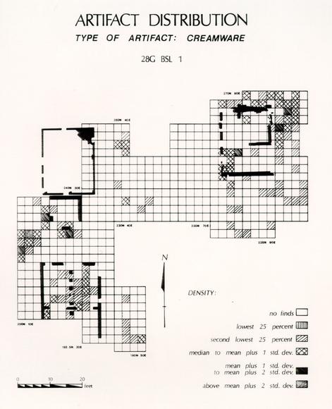 GRAPH - Figure 29
ARTIFACT DISTRIBUTION
TYPE OF ARTIFACT: CREAMWARE
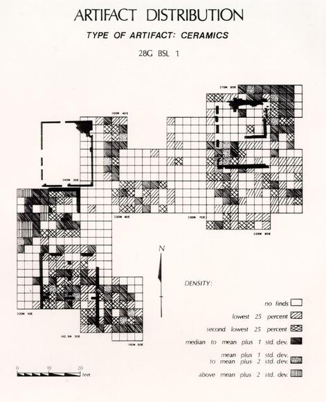 GRAPH - Figure 30
ARTIFACT DISTRIBUTION
TYPE OF ARTIFACT: CERAMICS
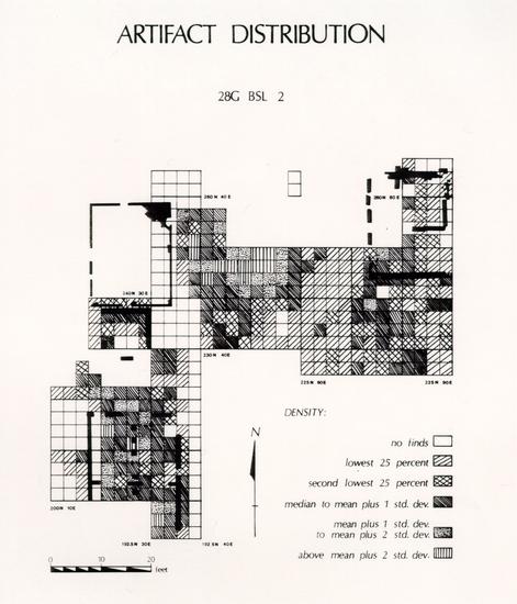 GRAPH - Figure 31
ARTIFACT DISTRIBUTION
 GRAPH - Figure 32
ARTIFACT DISTRIBUTION
TYPE OF ARTIFACT: WHIELDON/WEDGWOOD
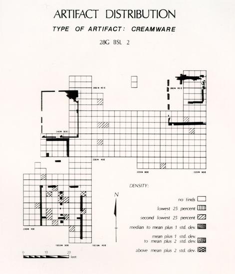 GRAPH - Figure 33
ARTIFACT DISTRIBUTION
TYPE OF ARTIFACT: CREAMWARE
GRAPH - Figure 33
ARTIFACT DISTRIBUTION
TYPE OF ARTIFACT: CREAMWARE
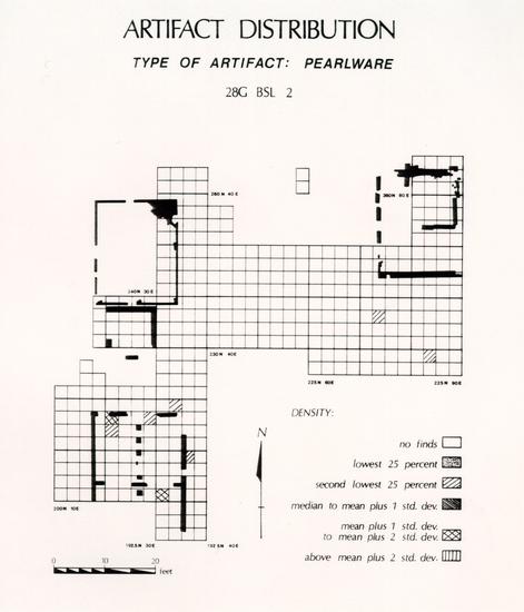 GRAPH - Figure 34
ARTIFACT DISTRIBUTION
TYPE OF ARTIFACT: PEARLWARE
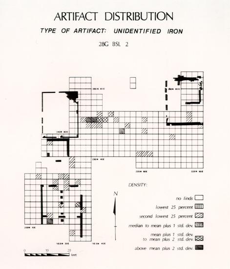 GRAPH - Figure 35
ARTIFACT DISTRIBUTION
TYPE OF ARTIFACT: UNIDENTIFIED IRON
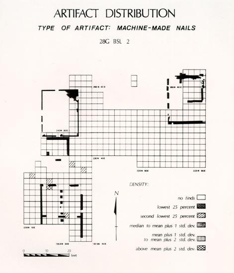 GRAPH - Figure 36
ARTIFACT DISTRIBUTION
TYPE OF ARTIFACT: MACHINE-MADE NAILS
 GRAPH - Figure 37
ARTIFACT DISTRIBUTION
TYPE OF ARTIFACT: WHITEWARE
 GRAPH - Figure 38
ARTIFACT DISTRIBUTION
TYPE OF ARTIFACT: DIPPED WHITE SALTGLAZE
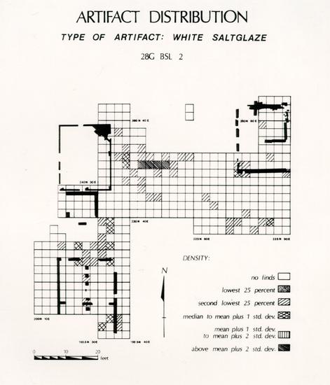 GRAPH - Figure 39
ARTIFACT DISTRIBUTION
TYPE OF ARTIFACT: WHITE SALTGLAZE
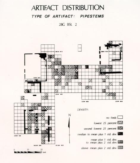 GRAPH - Figure 40
ARTIFACT DISTRIBUTION
TYPE OF ARTIFACT: PIPESTEMS
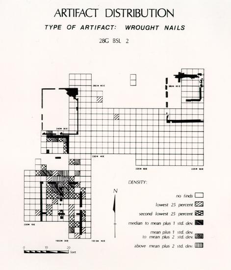 GRAPH - Figure 41
ARTIFACT DISTRIBUTION
TYPE OF ARTIFACT: WROUGHT NAILS
GRAPH - Figure 42
ARTIFACT DISTRIBUTION
TYPE OF ARTIFACT: TIN-ENAMELED EARTHENWARE
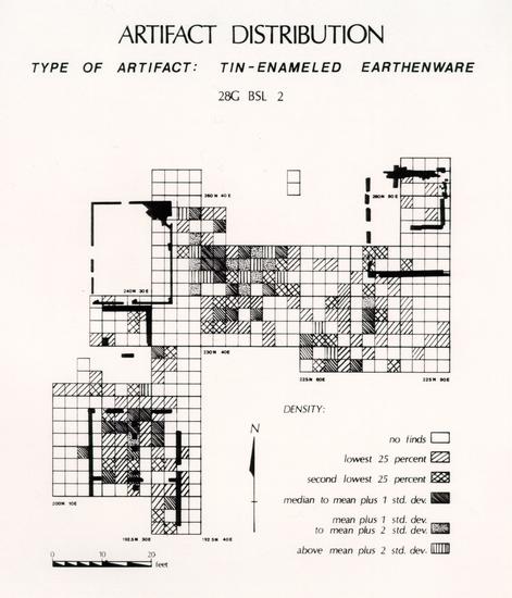 GRAPH - Figure 43.
ARTIFACT DISTRIBUTION
TYPE OF ARTIFACT: ALL NAILS
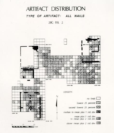 GRAPH - Figure 44.
ARTIFACT DISTRIBUTION
TYPE OF ARTIFACT: YORKTOWN COARSEWARE
CERAMIC SIZE
Five gross categories of ceramics were measured from the Brown Sandy Loam 2 layer. Earthenware, coarseware, refined earthenware, stoneware, and porcelain sherds were measured using a BEROL RAPIDESIGN R-140 large circle template. The ½", 1", 1 ½", 2", and 2 ½" diameter circles were used. A CERAMIC SIZE RECORD FORM was designed using INFOSTAR+ [version 1.6, 1984] (Fig. 43). The longest or largest side of the sherd was measured and recorded using the following criteria:
| If the sherd is smaller than ½", | regarded as: 0.5" |
| If the sherd is > ½" but < 1", | regarded as: 1.0" |
| If the sherd is >1" but < 1 ½", | regarded as: 1.5" |
| If the sherd is >1 ½" but < 2", | regarded as: 2.0" |
| If the sherd is >2" but < 2 ½", | regarded as: 2.2" |
Sherds larger than 2 ½" were not measured.
Obviously, an actual measurement of a sherd's longest side or surface area would have been the most accurate possible way of determining sherd size; however, the time involved in conducting the study in such a manner would have been prohibitive.
Results for BSL 2 were as follows:
| Type | # of Sherds | Average Size |
|---|---|---|
| Earthenware | 399 | .900" |
| Coarseware | 188 | 1.096" |
| Refined Earthenware | 45 | .911" |
| Stoneware | 214 | 1.207" |
| Porcelains | 102 | .933" |
These sizes compare closely with sherd size from the Marl Spread in 28H, a location where trampling of artifacts would also likely occur:
| Type | # of Sherds | Average Size |
|---|---|---|
| Earthenware | 22 | .800" |
| Coarseware | 10 | 1.000" |
| Refined Earthenware | 29 | .840" |
| Stoneware | 38 | 1.140" |
| Porcelains | 14 | 1.056" |
IV.K. WALKWAY # 1
 PHOTO 17. - Walkway #1, 28G Area
Walkway # 1 (Photo 17, above) ran about sixty-five feet north-south from the southern limit of excavation in 28G along the east sides of Structures E and A. At the northeastern corner of Structure A the walkway changed to an east-west course. This section of the walkway ran from the edge of the 1978 excavations along the north side of Structure A to the west side of Structure C, about thirty-seven feet. Walkway # 1 was composed of two main layers, an upper layer consisting of marl and crushed oyster shell, and a lower redeposited subsoil base. The extent of the walkway to the west is unclear, though remnants could be seen in the northern portion of excavation in the 1978 excavation area. These remnants were lost as the land grades towards North England Street. The southern side of the east-west section of the walkway was obliterated by the cross-trenching of the 1950s. Walkway # 1 was probably constructed as a service "road" connecting Structures C, E, and F to North England Street. Associated with Walkway # 1 was a possible earlier walk connecting Structures A and D.
90Only a small amount of the marl layer to Walkway # 1 remained intact (roughly a four by four and one-half foot patch), the rest having been destroyed by the plowing of the area in the nineteenth century (see Figure 46). This patch of marl may indicate there was an entire marl paving over at least the north-south section of the walkway. The surface of the redeposited subsoil base contained marl which had evidently been pushed down into the clay base during the use of the walkway. The remnants of the marl and shell surface measured from 0.075 to 0.1 feet in depth. Stratigraphically this marl lens lay underneath the plowzone of the mid-nineteenth century and above both the redeposited subsoil base to the walkway and the cultural layer designated "Brown Sandy Loam 1" (BSL 1). This relationship to BSL 1 is tenuous. The marl only sealed BSL 1 on the very edge of the walkway. It appears that the marl was deposited at about the same time as that BSL 1 began building up. The marl was placed on the subsoil base to keep carts and wagons from "bogging down" when the clay became wet and muddy from rain.
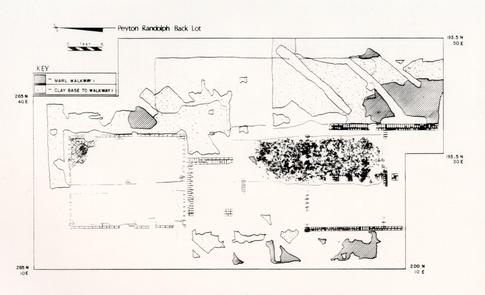 Figure 46 - Walkway #1, 28G Area
The second layer of Walkway # 1, the subsoil base, ranged in depth from approximately 0.5 feet in the north to about 1.2 feet in the south. Due to a disturbed and highly irregular eastern edge, the width of the walkway varied from seven to fifteen feet. This subsoil base also ties into the marl work area around Structure E. The width and depth of the subsoil base indicates plans for heavier traffic than simply a foot path. Stratigraphically, the subsoil base lay just under BSL 1, marl and plowzone. The earliest sheet refuse cultural layer, BSL 2, was cut by, and lay under, the subsoil base. On the east side of Structure E, where the base is deepest, it also intruded Planting Bed 3.
91Because of its stratigraphic location and its association with Structures E and F, the walkway appears to have been used in some form from the late 1750s to the mid-nineteenth century. The late 1750s are also the probable construction period for Structures E and F. The area appears to have been devoid of outbuildings and was subsequently plowed by the third quarter of the last century. The southern extent of the walkway appears to have been the area around Structure F, though that area was not re-excavated in the 1980s, as it was not encountered in the 28H area of the lot.
Walkway # 1 has two other important features. The first is its association with the marl work area around Structure E. It is in this area that the redeposited clay was deepest. The clay was underneath the several marl, shell, and mortar layers which together make up the work area, and the walkway merged with the work area on the eastern side of Structure E.
Secondly, Walkway # 1 adjoined Walkway # 2 on the western side of Structure C, thus servicing this building and offering access to the buildings serviced by Walkway # 2. Walkway # 1 had the same stratigraphic position as Walkway # 2 with one exception. Walkway # 2 had two layers which Walkway # 1 did not share: a brick paving near Structure C and a brick chip lens under the redeposited base.
IV.L. WALKWAY # 2
 PHOTO 18. - Walkway #2, 28G Area
Of the two major walkways located in the 28G area, Walkway # 2 (Photo 18, above) was the easternmost. The walkway ran north-south through units 230-270N 50-70E and, like Walkway # 1, was composed of several levels. Stratigraphically from top to bottom these levels included a layer of brick, marl, redeposited subsoil, and finally brick chips. Walkway # 2 serviced Structure C and probably Structure D as well, in an earlier form. Walkways # 1 and # 2 connected near the northwestern corner of Structure C, forming a loop. Unfortunately, the area of this loop was highly disturbed by the growth of two large pecan trees, preventing complete excavation. The southern limits of the Walkway # 2 were truncated by the Miller House, making excavation in that area impossible.
Adjacent to the west wall of Structure C, between the two large pecan trees, an area of brick paving was uncovered (Fig. 47). The paving had been placed over the marl level of the walkway, but survived only between the two trees. It is possible the paving had once extended further south, but had been removed when the area became a plowed field in the mid-nineteenth century. The remaining section measured 9.5' east-west by 9.0' north-south. Since no evidence of brick paving remained south of the pecan trees, it is possible that the paving represented a work area adjacent to Structure C, not existing over the walkway to the south. Ceramics recovered from the brick paving include English delft, English stoneware, Buckley, Jackfield, white salt-glazed stoneware, and pearlware. Other artifacts found consisted of nails, window and beverage glass, and iron fragments. No artifacts leading to a functional interpretation of the building were located.
The next level of the walkway was only slightly earlier than the brick paving and was composed primarily of marl. This marl level, unlike the brick paving, was 93 present in most of the units containing the walkway. Stratigraphically, the marl layer was superior to, and later than, the Brown Sandy Loam 2 layer, and contemporary with the BSL 1 layer (early nineteenth-century). This early nineteenth-century date for the marl layer makes almost certain a close relationship between the walkway and Structure C. Virtually devoid of artifacts, only two ceramic fragments were recovered from the marl: pieces of white salt-glazed stoneware and pearlware. It appears that the marl layer had been placed on the redeposited subsoil base in order to even the grade for the placement of the brick paving. This assumption is reinforced by the lack of artifactual remains.
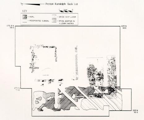 Figure 47 - Walkway # 2, 28G Area
A rather substantial redeposited subsoil base was located beneath the marl. The depth of this redeposited base was about 0.5 feet in the northern area, becoming slightly thinner towards the south. There were no artifacts found in this layer of the walkway. The layer was composed of a redeposited yellow sandy clay subsoil [Munsell: 10YR8/8] with light grey sandy clay and white silty clay mottlings [Munsell: 10YR6/1 and 8/2, respectively]. Though primarily sealed by the marl layer, the redeposited subsoil base was also sealed by BSL 1 and plowzone in several areas. The base was sealed by BSL 1 along the edges for a width of two to four 94 inches and was sealed by the plowzone in locations where the marl was not present, mostly towards the southern end. The marl layer here may have been plowed away, thus becoming incorporated in the plowzone.
The earliest layer in Walkway # 2 was composed of brick chips. It was neither as substantial nor as extensive as the other layers of the walkway. The layer was comprised of a yellowish brown and brown sandy loam [Munsell: IOYRS/3 and IOYR6/4], mixed with a heavy concentration of crushed brick. The layer was within Brown Sandy Loam 2 and was underlying the redeposited subsoil base. Unlike the three layers above it, the brick chip layer appears to have serviced Structure D rather than C, as it was associated with BSL 2 rather than the later BSL 1. The brick chip path was approximately three feet in width at its northern boundary, widening to nearly eight feet near the southern edge of excavation in unit 230N 60E. The length of the path was roughly twenty feet and the overall depth about one inch. The were no remains of the brick chip part of Walkway # 2 south of the 230N unit, so it is difficult to determine where the pathway led south of Structure D. The artifacts recovered from the brick chip layer were of little use in determining the temporal span of the path. English delft was the only ceramic type recovered, although undatable fragments of glass, bottle glass, shell and nails were also found.
In summary, the relationship between the earliest part of the walkway, the brick chip layer, and Brown Sandy Loam 2 indicates that the path was constructed during the middle phase of the BSL 2 build-up, in the second quarter of the eighteenth century. Falling from use after the destruction of Structure D in the mid-eighteenth century, it was replaced by a more substantial walkway at about the time Structure C was built. This new walkway was constructed using a redeposited subsoil base, forming the demarcation point between the two brown sandy loam sheet refuse layers. A small amount of the later BSL 1 (about 0.25 inches) had been deposited over the edges of the base, so it appears that the subsoil base was in use alone for a short while before the marl was laid down. The brick paving was laid over the marl and subsoil base near Structure C, possibly to provide a dry work space for whatever activities were taking place in the area. Walkway # 2 remained in use until the destruction of Structure C in the mid-nineteenth century when all outbuildings in the 28G area were razed for plowing.
IV.M. FENCE LINES
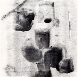 PHOTO 19. - Eastern North-South Fence Line
NORTH-SOUTH FENCE LINES
Evidence for two north-south fence lines was uncovered near the eastern and western limits of excavation in the 28G area. Composed of several multi-hole post show signs of extensive and long-term repair and replacement. The eastern fence line (Fig. 48) was composed of four post hole complexes running along the 90E grid line (Photo 19, above). The complexes formed a line which apparently separated lot 207 from lot 237, extending northward from the northwestern corner of Structure S over 250 feet to the northern edge of excavation in the 28G area. The stratigraphic record of the area east of this fence line was distinctly different from that to the west. The cultural activity was considerable west of the line, reflected in many lenses, layers, debris, features, and structures. The area east of the fence line was virtually devoid of activity, as illustrated in Photo 20. Brown Sandy Loam 1 and 2 were present only west of the fence line, whereas only topsoil, plowzone, and subsoil were represented east of the line. All activity associated with the Peyton Randolph House back lot was restricted to the area west of this fence.
Unfortunately, very few artifacts were found in association with either fence line, so dating the fences had to be left to stratigraphic evidence. The eastern fence line was sealed by Brown Sandy Loam 1, which was deposited principally in the early to mid-nineteenth century. All of the post hole complexes were located either within the BSL 2 layer, deposited from the second decade of the eighteenth century until the very late part of the same century, or intruding subsoil where the
96
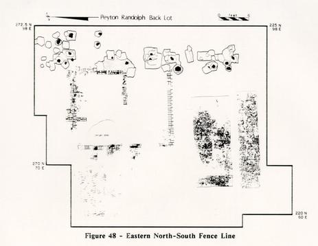 Figure 48 - Eastern North-South Fence Line
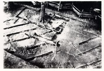 Photo 20. - Different Uses of Back Lot on Either Side of Eastern Fence Line
97
BSL 2 was absent. The fence line, probably erected during the Robertson or Holloway ownership of the property, appears to have been maintained until the destruction of Structure S.
Photo 20. - Different Uses of Back Lot on Either Side of Eastern Fence Line
97
BSL 2 was absent. The fence line, probably erected during the Robertson or Holloway ownership of the property, appears to have been maintained until the destruction of Structure S.
The western fence line was similar to the eastern one in that it was constructed in the same time period and was composed of numerous post hole complexes (Fig. 49). The western fence line was, however, far more complicated stratigraphically than its eastern counterpart. Most of the post hole complexes were sealed by both the west wall of Structure E and BSL 1. The western fence line ran north-south along the 20E grid line across the entire 28G area. Whether the line continued into the 28H excavation area is not known because, due to the modern sidewalk along N. England Street, the portion of the lot where the fence would have been was not excavated.
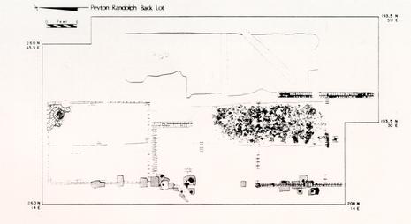 Figure 49 - Western North-South Fence Line
Artifacts recovered from the post hole complexes were not very diagnostic from a temporal perspective. Few were found from entirely reliable contexts, as most of the complexes were so stratigraphically confused by later intrusions that their definition was suspect. Portions of the fence line had been repaired or replaced as many as eighteen times. Sorting out the sequence of the features was so time-consuming that only a few of the complexes could be excavated.
In the earliest period of occupation on the lot, the western fence line probably led from the southwestern corner of Structure A southward (and possibly also northward). After the demise of Structure A the fence line was extended along the western edge of Structure A's west wall. The post holes associated with this extension were excavated in the winter of 1978 (see Appendix 4). It appears also to have been part of the west wall of Structure E until the wooden posts were replaced by a brick wall in the early nineteenth century (see section on Structure E). Very little of the lot was excavated west of the fence line because of a trench 98 containing a high-voltage electric line, but the stratigraphy on both sides appears to be similar.
In summary, both north-south fence lines appear to have been constructed in the very early periods of the lot's history. The purpose of the eastern fence is far clearer than that of the west. Whereas the eastern fence line did serve as a division between lots 207 and 237, the western fence line seems to have only separated the lot from the street. Both fences were down by the mid-nineteenth century.
EAST-WEST FENCE LINE
Part of a nineteenth-century fence line (Fig. 50) was uncovered near the southern edge of excavation in the 28G area. The significance of this line of four post holes is its relationship with plowzone in the back lot. The southern extent of the plowed area in 28G is just to the north of this fence line and it appears that this fence was erected to separate the cultivated area to the north from the yard area to the south. The fence line is located in units 210N 10-40E and probably continues towards the east. The construction of the Miller House in the first quarter of the twentieth century east of unit 210N 40E undoubtedly obliterated the continuation of the fence line.
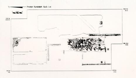 Figure 50 - East-West Fence Line
Four post holes were uncovered, each about eight feet from the other:
28G/1392
Post hole 28G/ 1392 was located in the northwestern quadrant of unit 210N 40E. The post hole measured 1.4' north-south and 1.6' east-west, and was sealed by Brown Sandy Loam 1. It intruded Walkway # 1 and subsoil, and it was partially intruded in turn by a 1955 cross-trench. The soil color was a "very dark greyish brown" [Munsell: 10YR3/2]. The fill was a fine-grained, friable loamy sand. Artifacts were principally residual in nature and included creamware, whiteware, yellow ware, Bennington, Fulham, dipped white salt-glazed stoneware, glass; bone, nails, and a cast copper alloy buckle.
28G/1294
28G/1294 was located in unit 21ON 30E and measured 1.4' by 1.1' by 1.4' in depth. It was sealed by backfill resulting from the 1955 cross-trenching. This post hole was dug through the east wall of Structure E. The fill was a "dark greyish brown" [Munsell: 10YR4/2], fine-grained, friable loamy sand. Artifacts recovered included Yorktown coarseware, yellow ware, Mn solarized glass, glass, nails, bone, iron, and a cast iron buckle. The terminus post quem was established at 1880.
28G/1684
28G/1684 was located in unit 210N 20E and measured 1.4' by 1.3'. It, too, was sealed by backfill. The soil in the post hole was a "brown" [Munsell: 10YR4/3] sandy loam, fine-grained and friable. Artifacts recovered included whiteware, Fulham stoneware, Chinese porcelain, glass, nails (wrought and cut), shell, and bone. The TPQ on this feature was also established at 1880.
28G/1696
28G/1696 was the post mold for post hole 1684. It contained a dark yellowish brown [Munsell: 10YR4/4], fine-grained, friable, sandy loam fill. Only a few artifacts were recovered from the post mold and a residual sherd of Chinese porcelain rendered the useless TPQ of 1690. The post mold was circular, c. 0.6' in diameter.
28G/1592
28G/1592 was located in unit 210N 10E and was the westernmost post hole uncovered. It measured 1.2' by 1.3' by 1.4' and was sealed by 28G/1470, a dark brown soil within the interior of Structure E. The post hole fill was a "brown" [Munsell: 10YR5/3], fine-grained, friable sandy loam. The fill contained delft, coarseware, whiteware, a pipe bowl fragment, glass, nails, bone, and some miscellaneous iron fragments. The TPQ was established at 1820, based on the presence of whiteware.
CENTRAL NORTH-SOUTH FENCE LINE
In addition to the long-maintained fence lines along the eastern and western boundaries of lot 207, another, later north-south line of post holes was found located just east of Walkway # 1 in the 28G area (Fig. 51). This fence line was placed on approximate 12 foot centers along the 40E row of units. The northern and southern extents of the fence are unknown, though the southernmost post hole in the line is 28G/1392 which is described above as the easternmost post hole in the east-west fence line. The post holes comprising this north-south fence predated the plowing of the 28G area, but post-dated the construction of Walkway # 1. It appears to have served as a boundary, of sorts, along the eastern edge of the walkway. The specific purpose of the fence is not known.
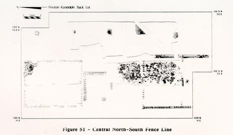 Figure 51 - Central North-South Fence Line
The features are described as follows:
28G/1392
28G/1392 (please see above for detailed description)
28G/1446
28G/1446 was located in unit 220N 40E and contains postmold 28G/1447. The post hole measured 2.5' by 2.5' and was sealed by the plowzone. The fill was a "brown" [Munsell: 10YR4/3] medium-grained, friable sandy loam. Artifacts recovered include delft, redware, creamware, Westerwald, white salt-glazed stoneware, pipe stems, glass, bone, shell, and machine-made nails. The TPQ was established as 1810. The post mold (28G/1447) was 0.66' in diameter, circular, and contained "black" [Munsell: 10YR2/1 ], fine-grained, friable sandy loam fill. No artifacts were recovered.
28G/1301
28G/1301 was located in unit 230N 40E and measured 1.6' by 1.9'. Post mold 28G/ 1302 was contained in the fill. The feature was sealed by plowzone and contained a "very dark grey" [Munsell: 1OYR3/1], medium-grained, friable sandy loam. Artifacts recovered included creamware, whiteware, pearlware, Fulham stoneware, Chinese porcelain, pipe stems, nails (wrought and cut), glass, Mn solarized glass, tin can fragments, bone and shell. The TPQ was established as 1880. The postmold measured 1.5' by 1.3' and contained a "very dark greyish brown" [Munsell: 10YR3/2], medium-grained, friable sand. Whiteware, glass, bone, shell, and iron were recovered from the post mold.
28G/1671 was located in unit 250N 40E and measured 1.0' by 1.4'. It was sealed by the plowzone. The post hole contained "brown" [Munsell: 10YR5/3], medium-grained, friable sandy loam and post mold 28G/1670. Artifacts recovered were few, only window and table beverage glass. The post mold measured 0.5' by 0.7' and contained a "greyish-brown" [Munsell: 10YR5/3], medium-grained, friable sandy loam. Artifacts recovered from the postmold included delft, pearlware, Chinese porcelain, window and bottle glass, nails, bone and shell.
28G/ 1149 was located in unit 260N 40E and measured 1.15' by 1.25'. It was sealed by the marl layer of Walkway # 1. The fill within the post hole was a "very dark greyish brown" [Munsell: 10YR3/2], fine-grained, coherent sandy clay. Artifacts retrieved included delft, whiteware, window glass, bottle glass, bone and shell. A TPQ of 1820 was assigned, based on the presence of whiteware.
IV.P. PLANTING BEDS
The most dramatic and potentially the most informative finds made during the 1982-1985 excavation effort were the garden features uncovered in the 28G area. Four vegetable gardens or planting beds were found and excavated. Each bed was different from the other in several respects, which presented a number of excavation problems. The information to be gathered, the physical attributes of each bed, weather, and time allowed for excavation all affected the recovery technique. Upon the discovery of the first two planting beds it became evident that a unique opportunity to gather new information from previously undiscovered and relatively intact, discrete early eighteenth-century features at Peyton Randolph had presented itself. The standard archaeological questions, i.e., when, what, who, how, and why, were naturally the first to be addressed. Other questions arose regarding how the beds related to the owners of the main house, whether they were formal gardens or vegetable patches, the kind of fertilizer that was used, if any, and the non-dietary use of faunal material.
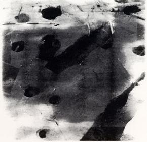 Photo 21 - Differential Drying Over Planting Beds 1 and 2
PLANTING BEDS 1 AND 2
Planting Beds 1 and 2 are described together because of their similarity and the fact that they were found together and simultaneously excavated using the same method. Planting Bed 1 was discovered in the summer of 1983. July had been a particularly hot and dry month, which was causing most of the excavation area to "bake-out," i.e., to become hard and dry, making the features and layer mottling obscure, and turning all the soil the same light grey color. In spite of the drying of the soil, an irregularly-shaped rectangular area in the 240N 80-90E section of the site remained dark and moist (Photo 21, opposite). As the last layer above subsoil, Brown Sandy Loam 2, was being removed, the once-amorphous rectangular damp spot became a well-defined eight by twenty foot feature. The edge of another similar feature soon became evident just a foot south along the edge of the excavation area. The overburden and successive layers over the second feature were excavated as quickly as possible, and by August both beds were exposed (Photo 22). The second bed was at the same stratigraphic level as the first, but was only half the size. It measured twenty feet east-west, just as Planting Bed 1, but was only four feet wide instead of eight. The beds were parallel to each other with approximately one foot of subsoil separating them.
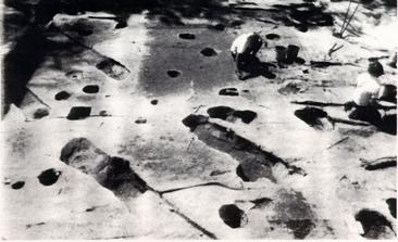 Photo 22 - Planting Beds 1 and 2 (Unexcavated)
In order to obtain maximum recovery of artifacts, floral material, faunal material, and soil data while maintaining excavations through an encroaching winter, each of the beds was divided into eight sections (Fig. 52, next page). The placement of the sections was determined both by the rectangular shape of the beds as well as the grid system imposed on the site. Since the fill within the beds appeared consistent, it was divided vertically into arbitrary levels. These levels received context numbers according to which unit each was in, along with a Roman numeral denoting within which of the eight sections it lay. For example, the first
104
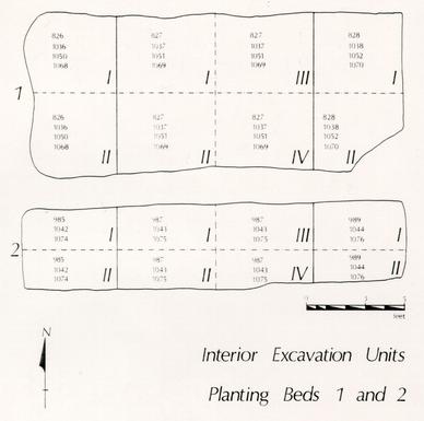 Figure 52 - Excavation Divisions
arbitrary 0.5 foot level in the northeastern section of Planting Bed 1 received context number 828 followed by the Roman numeral "I," the southeastern section received the same context number because it was in the same unit, but was
followed by "II," denoting the section. The second planting bed was divided similarly; however, since the smaller bed was also shallower, it was divided into three 0.4 foot arbitrary levels rather than four 0.5 foot levels as was Planting Bed 1. Each bed was excavated in such a manner that three north-south section drawings were made across each bed as well as one east-west section across the entire length of each. Soil samples were taken from each level in each section and placed in ten by thirteen inch plastic lock-top bags. Thirty-three percent of each bed was wet-screened through one-millimeter mesh on site and the heavy fraction collected for analysis.
Upon reaching the bottom of both beds it was discovered that each was paved with numerous glass bottle bases, necks, and fragments. Some oyster shell, bone, and ceramics were among the bottle fragments, but glass was the predominant paving material. Approximately 60% of Planting Bed 1 was paved, and over 90% of 105 the bottom of the smaller bed was covered with early eighteenth-century artifacts. The soil was carefully cleaned from the paving and a scale drawing (Fig. 53, below) and an overall photograph (Photo 23, next page) were made before the paving was removed. Separate context numbers were given to the paving material and the soil trapped under the bottle kicks, oyster shell, and ceramic fragments.
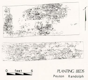 Figure 53 - Detail of Paving Material, Planting Beds 1 and 2
The placement of the bottle, shell, and bone fragments reflects a conscious effort on the part of the person or persons paving the bed to place, rather than dump, the debris into the bottom of the beds. Nearly all of the bottle bases were placed bottom up, the shell placed exterior up, and the flat side of the long bones placed up. Nearly as intriguing as the paving was where the paving was absent. Space in the beds where no paving existed appeared several times in long, thin lines as much as eight feet in length and 0.1-0.2 feet wide. There also appears to be a clear and straight line of demarcation between the paving and absence thereof in 106 the western and north-central quadrants of Planting Bed 1. This appears to have been a board (long since deteriorated) or some sort of barrier against which some of the paving was placed. Whether this action related to the type of vegetable planted in the various areas of the bed, or occurred for some other reason, is not known.
 Photo 23 (right) - Overall, planting Beds 1 and 2
PLANTING BED 3
Planting Bed 3 (Photo 24) was located in units 200-240N 30-50E approximately twenty feet west of the first two beds. This bed was larger than the others, measuring about thirty-two feet in length and twelve feet in width. Unlike Planting Beds 1 and 2 its long axis was oriented north-south rather than east-west. The northern part of Planting Bed 3 was evident in late 1983 while the first two beds were being excavated. It is noticeable in the background of an overall photograph of the paving of Planting Beds 1 and 2 (see Photo 23). Planting Bed 3 was the least well-preserved bed of the four discovered, for a variety of reasons. The bed had been highly disturbed in the late eighteenth or early nineteenth century by the construction of a deep redeposited subsoil base for Walkway # 1. Most of the fill was removed from the bed by this endeavor. Cross-mending of artifacts from the bed with other layers and features illustrates that much of the fill had been distributed over a fairly wide area.
In addition, several post holes and Structure E had been built along the western edge of the bed, and an electrical service line for the Miller residence was dug through the center of the bed in the 1920s. Making an already poor situation worse, the bed had to be excavated during the winter and spring wet months, under tents.
The excavation technique decided upon for Planting Bed 3 was simple adherence to the sub-unit demarcations. Not enough fill remained to denote arbitrary levels within it, and the bed was large enough to render good
107
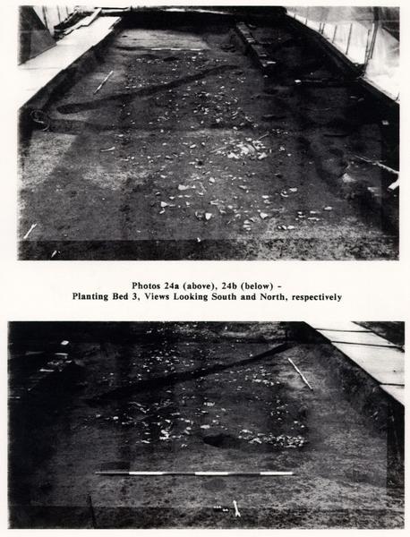 TWO PHOTOGRAPHS - Photos 24a (above), 24b (below) -
Planting Bed 3, Views Looking South and North, respectively
108
distributional analysis with the use of the standard 2.5 foot square sub-unit. Planting Bed 3 was paved, though not as heavily as the other beds, and with a different principal material: bone. Other materials were present in the paving—the same materials represented in the other beds (glass, oyster shell, ceramics), just in smaller amounts. Soil samples were taken from alternating whole sub-units, with approximately 40% of all the sub-units represented. Wet-screening was not done on site, but in the laboratory due to inclement conditions.
TWO PHOTOGRAPHS - Photos 24a (above), 24b (below) -
Planting Bed 3, Views Looking South and North, respectively
108
distributional analysis with the use of the standard 2.5 foot square sub-unit. Planting Bed 3 was paved, though not as heavily as the other beds, and with a different principal material: bone. Other materials were present in the paving—the same materials represented in the other beds (glass, oyster shell, ceramics), just in smaller amounts. Soil samples were taken from alternating whole sub-units, with approximately 40% of all the sub-units represented. Wet-screening was not done on site, but in the laboratory due to inclement conditions.
The alternating extremely wet (i.e., inundated) to relatively dry conditions were not kind to the faunal material paving the bed. The bones that could be excavated in whole pieces without prior treatment were immediately wrapped in damp paper towels at the site and kept wet until stabilized in the conservation lab. The extremely deteriorated bones were treated in the field with ethyl alcohol and Butvar (a liquid plastic) until they were stable enough to remove with the surrounding soil.
PLANTING BED 4
Planting Bed 4 (Photo 25) was discovered late in the 1984 field season, after the removal of Brown Sandy Loam 2 and most of Structure E from the area just to the west of Planting Bed 3. The fourth bed was located 200-230N 20-30E, measured 29 feet north-south and eight feet east-west, and was about 0.5 feet in depth. The northern quarter of the bed had been highly disturbed by numerous eighteenth- and nineteenth-century post holes. The presence of Structure E, which stood for some time over the majority of the bed, protected it from even more disturbance.
Excavation of the planting bed fill was carried out in sub-units as was done in Planting Bed 3. The fill was screened through one-eighth inch hardware cloth and soil samples were taken from every other one of the sub-units. No on-site wet screening was done because of the cool fall weather. The paving encountered in this bed proved to be of the same type of material as the others. However, in this last bed the majority of the paving was oyster shell rather than glass or bone. Significant amounts of glass, bone, and ceramics were recovered from the paving as well.
SUMMARY
The stratigraphic context of all the beds was essentially the same, i.e., all were found at the lowest stratigraphic context above subsoil with the exception of the seventeenth-century boundary ditch which is truncated by Planting Bed 4. The early periodization of the beds is supported in the artifact record as well. The beds appear to have been built at approximately the same time as the main house and were in use until about 1740. The beds, although arranged along the north-south and east-west axes, do not appear to have any formal or ornate arrangement. They seem to have been primarily vegetable gardens. The diversity in paving material relates either to a difference in plant types being cultivated, or to experimentation with drainage materials. Drainage is posed as the only logical reason for having paved the bottoms of the beds. Experience in digging holes into the area's subsoil illustrates the need for some sort of material to keep cultivated plant roots from rotting in the rain water trapped by the less than well draining
109
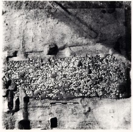 Photo 25 - Planting Bed 4
subsoil. Alternate reasons for glass paving have been forwarded, from discouraging rodents from eating the tender roots to trash disposal. Whereas glass may fend off root-eating rodents, the bone and oyster shell predominant in the other beds would not. Regarding trash disposal, the paving material was obviously placed in the beds, not discarded as trash would have been.
In addressing the obvious archaeological question concerning who built the beds, the answer is unknown. However, if the beds could have been constructed as late as the early 1720s and were used until the late 1730s or early 1740s, their use-span coincides rather well with Sir John Randolph's ownership of the property (1724-1737). Indeed, Sir John's brother, Captain Isham Randolph of Dungeness, had 110 Additionally, both Sir John's and Isham's knowledge of Virginia wild flowers is inferred in a letter from Williamsburg's John Custis to British horticulturist John Collinson (Swem 1957).
The plots may also represent the cultivation of household food crops for use by the tenant who may have been residing in nearby Structure A. It is doubtful, however, that a tenant of meager means would go to the singular trouble of experimenting with drainage materials.
There is evidence for this type of planting technique some fifty to seventy-five years later, however. Judge Joseph Prentis' unpublished garden calendar, written near the end of the eighteenth century, contains the following passage regarding the planting of asparagus:
Set out asparagus as follows. Dig a trench as wide as you intend your Beds to be, and two feet deep, lay a layer of Oyster Shells, six Inches, then lay on six Inches of Horse Dung, and as much Mould, continue so to do, till the Bed is done. Take your Roots raised from Seed, and set them out in Rows, a foot Wide, let there be a space of about a foot between each Row (Webb-Prentis Papers, in Brown and Samford, in press).
At least by the end of the century, gardeners may have standardized what may have been experimental at the time these beds were constructed.
Why the diverse types of paving and where they came from are also questions the archaeological record can only attempt to answer. None of the paving appears to be solely household refuse. This is deduced from the absence of personal items such as combs, buttons, pipe stems, etc. in the paving. There are also no small fish or fowl bones, only large bones from fairly large animals. There are indications that much of the paving material was purchased as refuse from vendors. Most of the bones have heavy butcher marks, and a few are those of a horse, not an animal the average colonial family is likely to butcher and smoke in the back yard. There are also a disproportionate number of mandibles and cranial fragments represented. The glass bottles do not seem to have all been broken on the site and placed in the bed, but rather brought to the site as scrap glass. There are many more bottoms than necks, and reconstruction of bottles from base to lip was accomplished in only six cases. Cross-mends of bottle glass from the surrounding BSL 2 and Planting Beds 1 and 2 have been made, however, indicating that there was at least some breakage on the site.
The uniqueness of the four beds, especially the paving materials, will be a continuing source of study for some time. Hopefully, other similar beds will be located in the area during future archaeological excavations, providing a larger comparative study of early eighteenth-century gardening practices.
IV.Q. MIDDLE PLANTATION FEATURES
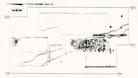 Figure 54 - Middle Plantation Era Boundary Ditch with Associated Post Holes
Several features located in the back lot of the Peyton Randolph house have been attributed to the Middle Plantation Period. Middle Plantation was established after the Indian Massacre of 1622, along a ridge between the York and James Rivers. The site was less swampy than the low-lying capital at Jamestown, and though accessible by navigable creeks to the two rivers, it was not located directly on either. In 1633/34 a palisade was erected in order to secure the area from Middle Plantation to Hampton Roads from Indian attacks. Also providing grazing and foraging land for cattle, the palisade passed very near the present Peyton Randolph site. After the second Indian Massacre of 1644, a new palisade was built just northeast of the original one but still within Middle Plantation.
The College of William and Mary was established at Middle Plantation in February of 1693. At that time the settlement consisted of Bruton Parish Church, Burwell's Ordinary, several stores, two mills, a smith, a grammar school and several residences. When Virginia's capital was moved from Jamestown to Middle Plantation in 1699, streets were laid out in a north-south, east-west pattern and the city was re-named Williamsburg, after the reigning monarch.
The only evidence of the Middle Plantation Era found at the Peyton Randolph Site was a boundary ditch (Fig. 54) and several post holes which appear to be in association with this ditch. The ditch was first discovered during the 1978 archaeological investigation of the west half of Structure A (see Appendix 4). According to Klingelhofer, author of the 1978 Interim Report, the ditch was approximately four feet wide and one foot, two inches deep, containing only a few nail fragments. The only section of the ditch excavated at that time was on the exterior of Structure A, though it extended under the southwestern corner of the 112 structure. The part of the ditch in the interior of Structure A was sealed by a silty dark brown loam believed to be buried topsoil from the time the building was constructed. Though the ditch had probably been filled in somewhat when Structure A was built, it had not fully compacted and was quite evident to the builders. A line of rowlock brick, of the same color and consistency of those used to construct the piers in Structure A, was discovered placed across the ditch supporting the southwestern pier (see Photo 6).
From the edge of the excavated area near Structure A, the ditch continued in a direction approximately 23° east of south, running under nearby Structure B, Planting Bed 4, and the east wall of Structure E (see Fig. 54, previous page). The ditch had fully compacted by the time Structures B and E were built as it had no effect upon their respective foundations. The ditch continued across the 28G area past the southern edge of excavation. It was located again in the 28B area near the southwestern corner of Structure R. The full extent of the boundary ditch is unknown, though it is probably many times more extensive than the 150 foot section which passed through the Peyton Randolph site.
The sections of the boundary ditch that were excavated in 1985 contained brown to dark brown sandy loam [Munsell: 10YR4/3] with fine-grained sand. They were sealed by Brown Sandy Loam 2 and Planting Bed 4, intruding sterile subsoil. The only artifacts recovered from any part of the feature were a fragment of bottle glass and several highly oxidized nails.
This boundary ditch has been ascribed to the seventeenth-century Middle Plantation Period for several reasons. It was located at the lowest stratigraphic level, intruding only subsoil. It was not oriented on the Williamsburg Period north-south, east-west axes as were all other features discovered at Peyton Randolph. Finally, it contained very few artifacts considering its extent, which indicates that little cultural activity had taken place in the area when the ditch was constructed or when it was being in-filled.
Three post holes, found near the southern edge of the excavation area in 28G, appear to be in association with the boundary ditch. All three were located at the same stratigraphic level as the ditch. Unfortunately, they do not seem to form any pattern which permits their interpretation, nor did they- contain any significant artifacts. They are described as follows:
28G/2071
Located in unit 200N 30E, the post hole measured 0.7' north-south, 1.2' east-west, and was 0.2' in depth. The fill was 10YR4/4 in color and contained several fragments of green glass and bone.
28G/2073
Located in unit 210N 30E, the post hole measured 0.65' north-south, 0.9' east-west, and was 0.15' in depth. The fill was also 10YR4/4 in color and contained several brick fragments.
28G/2075
Located in unit 200N 40E, the post hole measured 0.8' north-south, 0.85' east-west, and was 0.3' in depth. Again, the fill was 1OYR4/4 in color, but the feature contained no artifacts.
No other features from the Middle Plantation Period were discerned at the Peyton Randolph site.
114CHAPTER FIVE:
DESCRIPTION OF MAJOR FINDS, 28H AREA
 ISOMETRIC DRAWING Of AN 18th CENTURY WINE CELLAR
Peyton Randolph Site May 1985
ISOMETRIC DRAWING Of AN 18th CENTURY WINE CELLAR
Peyton Randolph Site May 1985
V.A. MODERN INTRUSIONS AND TOPSOIL
The first modern intrusions encountered in the 28H area were in the section cross-trenched in 1955. This was in what was at the time the Skillman House front yard. Part of the disturbance was apparently related to the construction and destruction of the Skillman House. Fortunately this activity did little but mix the topsoil layers, leaving the rest of the stratigraphy basically intact. A modern clay and gravel walkway associated with the house was located just under topsoil at the northern end of the excavation. A lead-encased telephone (?) line, which traversed the northern three excavation units from west to east leading to the Skillman House, was also relocated. This line is shown in a 1955 photograph taken during the previous cross-trenching (Photo 26), and did little damage to the stratigraphic record.
Also associated with the Skillman House was the city water line which was, according to the Skillmans (Andrea Foster, personal communication), put in when the house was built in 1924. It ran from the western edge of excavation across three units to the eastern edge only inches south of the well. The pipe trench was
116
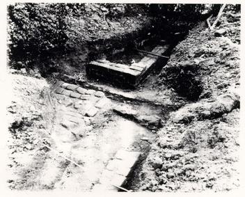 Photo 26 - Telephone Line in 28H Area, 1955
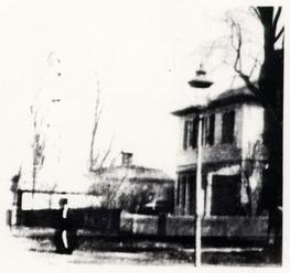 Photo 27 - Late Nineteenth-Century Windmill at Peyton Randolph Site
117
approximately a foot wide and 18 inches deep. Another water line led from the eastern edge of the well to the eastern edge of excavation. This pipe was associated with a windmill which stood over the well from the late nineteenth century until 1920. This windmill appears in an archival photograph (Photo 27, previous page) which was taken around the turn of this century. The building serviced by the windmill must be the large structure to the east, but the temporal and functional aspects of the building are unknown. It was located partly where the Skillman House once stood and partly where the parking lot for the life tenant now exists, and was therefore not excavated during any of the archaeological investigations of the back yard. The windmill had four supports placed around the well. Each was dug into the ground some four feet. Only one of the support features was fully excavated, the one on the northeastern edge of the well. Each dimension was four feet. The feature contained many early twentieth-century artifacts.
Photo 27 - Late Nineteenth-Century Windmill at Peyton Randolph Site
117
approximately a foot wide and 18 inches deep. Another water line led from the eastern edge of the well to the eastern edge of excavation. This pipe was associated with a windmill which stood over the well from the late nineteenth century until 1920. This windmill appears in an archival photograph (Photo 27, previous page) which was taken around the turn of this century. The building serviced by the windmill must be the large structure to the east, but the temporal and functional aspects of the building are unknown. It was located partly where the Skillman House once stood and partly where the parking lot for the life tenant now exists, and was therefore not excavated during any of the archaeological investigations of the back yard. The windmill had four supports placed around the well. Each was dug into the ground some four feet. Only one of the support features was fully excavated, the one on the northeastern edge of the well. Each dimension was four feet. The feature contained many early twentieth-century artifacts.
TOPSOIL 2
The layer designated "Topsoil 2" was first encountered when excavation of the 28H area was begun. The layer was not found in the 28G area, probably because of the extensive plowing done in the last century. "Topsoil 2" was used to denote that layer which was topsoil until the destruction of the Skillman House in the 1970s. After the house was removed, the Colonial Williamsburg Foundation graded the area and did minor landscape work between the present access driveway and the main house. This layer of recent fill was designated "topsoil" and was removed along with the sod. The layer below was called Topsoil 2, and contained somewhat older material.
Topsoil 2 varied in thickness from 0.1' to 0.5'. It was absent only in the area of the old driveway between the Skillman House and the Randolph House, and in places where it was disturbed by the 1930s and 1950s excavations, as well as other modern landscaping.
The layer was removed in 10 x 10 foot units only. All of the layer was excavated by trowel, and approximately 20% was screened through quarter-inch hardware cloth. Soil color ranged from black [Munsell color. 10YR2/1] to light brownish grey [Munsell: 10YR2/1], depending upon dampness and lighting conditions. Texture tests in the field described Topsoil 2 as a sandy loam. The preliminary terminus post quem was 1907.
V.B. MARL WALKWAY # 1
 Figure 55 - Marl Walkway #1, 28H Area
The archaeological remains of the feature designated Marl Walkway # 1 (Fig. 55, above) were sketchy at best. Recent intrusions such as the Skillman House and associated utilities, hedges, etc., as well as the 1930s and 1950s archaeological work, significantly obscured the original configuration of the feature. The artifacts recovered from the marl walk indicate a TPQ of 1820, though the diagnostic indicator—whiteware—was not recovered in significant amounts (only four sherds out of a total of 1,516 artifacts). Stratigraphically, the feature sealed the c. 1795 Refuse Layer discussed later in this report. The walkway was sealed in turn by Topsoil 2, with a TPQ of 1907. Unlike Walkway # 2, the most prevalent ceramic type recovered was creamware, with pearlware representing a significant second most prevalent type. Delft and white salt-glazed stoneware were ranked forth and fifth in frequency of occurrence rather than first and second as in Walkway # 2. Walkway # 1 probably performed a similar function as that of Walkway # 2, though it was not as extensive and could not be regarded as a yard spread, but rather a simple walkway from the kitchen (Structure L) to the well, Structure G, and Structure H. Though very disturbed in the area near the porch appendage to Structure L, the walk appears to be related to the porch, unlike the older marl spread which was in place when the appendage was constructed. This marl walkway is probably attributable to the Peachy occupation of the house (1800-1860).
V.C. MARL WALKWAY # 2
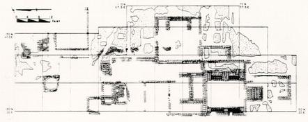 Figure 56 - Marl Walkway #2, 28H Area
Marl Walkway # 2, or the Marl Yard Spread as it was also called, was found below the Refuse Layer described in chapter V.D. This rather well packed layer of marl (Fig. 56, above) was located east of Structure L, between it and Structures P, Q, and R. The purpose of the c. 0.2-0.3 foot thick paving was apparently to provide a stable surface to the area around the main kitchen. The remnants of a brick walk were imbedded in the yard paving leading to the well area. The marl extended northward to the south wall of Structure H, probably abutting the building before this section was removed during the 1930s excavations.
Artifacts recovered from the marl rendered a tentative TPQ of 1820, derived from two small whiteware sherds. If these are disregarded as mechanically displaced, a TPQ of 1779 is indicated. The most frequently encountered ceramic types recovered from the Marl Spread were delft, white salt-glazed stoneware, Chinese porcelain, creamware, and Fulham-type stoneware. Overall, the most numerous artifact types were bottle glass, bone, window glass, and wrought nails (see below for artifact count and percentages). Artifact types did not tend to indicate functional differences in the area of the marl, but rather represented the usual assemblage of domestic debris. Artifact density was also rather low, with a total of only 617 artifacts having been recovered from the layer, which was located in thirteen separate units. The low density is to be expected from a layer which was probably "mined" from a nearby outcropping, spread over the area in a short period, and most likely swept clean of debris on a regular basis. The presence of a significant amount of pearlware (eleven sherds) indicates a deposition after 1779, and probably after the house was sold at auction in 1783. The spread may have been deposited as late as the first decade of the nineteenth century, but this possibility is unlikely since the Refuse Layer covering it was probably deposited at this time, and it would be illogical to pave an area and then almost immediately deposit fill on top. The Marl Yard Spread is therefore attributed to the Hornsby occupation of the house (1783- 1800).
120| Type | Count | Percent |
|---|---|---|
| Bottle glass | 174 | 28.20% |
| Bone | 159 | 25.77% |
| Window glass | 58 | 9.4% |
| Wrought nails | 44 | 7.13% |
| English delft | 24 | 3.89% |
| White salt-glazed stoneware | 24 | 3.89% |
| Chinese porcelain | 18 | 2.92% |
| Creamware | 16 | 2.59% |
| Pipe stems | 13 | 2.11% |
| Glass | 12 | 1.94% |
| Fulham stoneware | 11 | 1.78% |
| Pearlware | 11 | 1.78% |
| Leaded glass | 11 | 1.78% |
| Copper alloy | 11 | 1.78% |
| Shell | 8 | 1.30% |
| American stoneware | 4 | 0.65% |
| Redware | 3 | 0.49% |
| Slipware | 3 | 0.49% |
| Yorktown | 2 | 0.32% |
| Whiteware | 2 | 0.32% |
| Iron objects | 2 | 0.32% |
| Pewter/lead | 2 | 0.32% |
| Colono-ware | 1 | 0.16% |
| Westerwald | 1 | 0.16% |
| Porcellaneous | 1 | 0.16% |
| Pipe bowls | 1 | 0.16% |
| Machined nails | 1 | 0.16% |
| Whieldon ware | 0 | 0.00% |
| Refined earthenware | 0 | 0.00% |
| Bennington stoneware | 0 | 0.00% |
| TOTAL | 617 | 100.0% |
V.D. REFUSE LAYER
 Figure 57 - Refuse Layer, 28H Area
Located principally in units 110N 40E, 120N 40E, 110N SOE, and 120N SOE, between Topsoil 2 and the Marl Yard Spread, was a layer of secondary fill approximately 0.4 feet in thickness (Fig. 57, above). The soil was a grey brown sandy loam [Munsell: 10YR5/2] containing inclusions of shell, bone, fossils, and charcoal as well as an extremely high concentration of eighteenth- and nineteenth-century artifacts. Cross-mending of the major ceramic types with other layers and features from the site produced no glue-fit mends, indicating strongly that the fill had its origins elsewhere, having been brought to the Peyton Randolph back yard in order to fill in a low area of the site. The exact eastern edge of the layer was not investigated, though it was not encountered in the area around Structures P, Q, and R east of the marl walkway. The layer extended to the west only to within about two feet of the eastern wall of Structure L, and, though extant northeast of the Structure J hearth, was very disturbed. It was not found within the interior of Structure H, but probably abutted its south foundation wall before the 1930s excavations interrupted the stratigraphic sequence associated with the structure.
122The density of the artifact concentration can be illustrated grossly in sheer numbers. For example, in unit 120N 40E, the refuse layer covered approximately 80% of the square and yielded 9,649 artifacts—1,575 from one 2.5 by 2.5 foot sub-unit alone! Ceramic types included:
- English delft, plain white
- English delft, blue and white
- English delft, manganese
- North Devon gravel coarseware
- Colono-ware
- Staffordshire mottled coarseware
- redware
- Yorktown coarseware
- redware, unglazed
- slipware
- Staffordshire slipware or "dotware"
- Whieldon/Wedgwood cauliflower
- creamware, royal
- creamware, feather-edged
- creamware, molded
- refined earthenware, green glaze
- pearlware
- pearlware, transfer printed
-
- monochrome
- Westerwald stoneware
- Nottingham stoneware
- Fulham stoneware
- white salt-glazed, bead reel
- white salt-glazed, hand painted overglaze
- white salt-glazed, debased scratch-blue
- white salt-glazed, plain
- Jackfield ware
- Chinese porcelain, Batavian
- Chinese porcelain,
-
- bianco supra bianco
- Chinese porcelain, plain
- Chinese porcelain, hand painted
- underglaze
- Chinese porcelain, hand painted
-
- overglaze
- Chinese porcelain, hand painted
-
- under and overglaze
- bone china, porcellaneous
In addition to a vast variety of eighteenth- and nineteenth-century ceramics were glass vessels, nails (both wrought and machine-made), clay pipe bowls and stems, worked stone, brick, mortar, bone, shell, carbonized wood, coal, iron, brass, pewter, and lead. A sample analysis of finds from two units, 28H/299 and 28H/300, represented by 11,125 artifacts, indicated the majority were bottle glass fragments (29.65%), bone (20.78%), and window glass fragments (13.12%). Creamware was the most often recovered ceramic (5.12%).
The material had probably not been seriously trampled. The average sherd diameter was 1.006 inches for all ceramics, somewhat larger than those recovered from the Marl Spread that the layer covered. This fact tends to suggest that the layer was probably deposited as fill, not as a "living" surface.
A complete breakdown of thirty-six artifact types from the two units, in order of frequency, is as follows:
123| TYPE | COUNT | PERCENT |
|---|---|---|
| Bottle glass | 3299 | 29.65% |
| Bone | 1549 | 20.78% |
| Window glass | 1460 | 13.12% |
| Wrought nails | 849 | 7.63% |
| Creamware | 570 | 5.12% |
| English delft | 345 | 3.10% |
| Chinese porcelain | 333 | 2.99% |
| Oyster shell | 329 | 2.96% |
| Leaded glass | 236 | 2.12% |
| White salt-glaze stoneware | 190 | 1.71% |
| Coal | 184 | 1.65% |
| Glass | 131 | 1.18% |
| Ferrous objects | 128 | 1.15% |
| Pipe stems | 96 | 0.86% |
| Slipware | 93 | 0.84% |
| Copper alloy objects | 89 | 0.80% |
| Fulham stoneware | 87 | 0.78% |
| Redware | 74 | 0.67% |
| Yorktown-type earthenware | 58 | 0.52% |
| Pearlware | 55 | 0.49% |
| Pipe bowls | 41 | 0.37% |
| Pharmaceutical | 36 | 0.32% |
| Westerwald stoneware | 20 | 0.18% |
| Pewter objects | 17 | 0.15% |
| Colono-ware | 16 | 0.14% |
| Machined nails | 16 | 0.14% |
| Whieldon ware | 14 | 0.13% |
| Rouen faience | 10 | 0.09% |
| North Devon | 7 | 0.06% |
| Nottingham stoneware | 7 | 0.06% |
| Staffordshire | 6 | 0.06% |
| Worked stone | 5 | 0.04% |
| Refined earthenware | 4 | 0.04% |
| Porcellaneous | 4 | 0.04% |
| Buckley | 2 | 0.02% |
| Jackfield | 1 | 0.01% |
| Whiteware | 1 | 0.01% |
| TOTAL | 11,125 | 100.00% |
Mending within the entire layer produced fragments of 101 unique vessels:
Creamware (30 vessels):
- 2 Royal pattern plates
- 6 feather-edge plates
- 3 feather-edge platters
- 5 tea bowls
- 3 saucers
- 2 bowls
- 1 chamber pot
- 1 plain platter
- 1 basket
- 1 sauce boat
- 1 tea pot lid
- 1 tankard
- 1 large saucer
- 1 milk jug
- 1 small bowl
Delft (16 vessels):
- 4 plain chamber pots
- 3 plain bowls
- 2 plain plates
- 2 blue and white plates
- 1 manganese and white
- 2 blue and white punch bowls
- 1 can
- 1 polychrome bowl
Chinese porcelain (20 vessels):
- 8 blue under glazed plates
- 2 polychrome plates
- 2 plain tea bowls
- 2 blue under glazed tea bowls
- 1 platter
- 1 pitcher
- 1 bowl
- 1 lidded vessel
- 1 can
- 1 saucer
White salt-glazed stoneware (13 vessels):
- 2 bowls
- 2 tea pots
- 1 chamber pot
- 1 sweetmeat dish
- 1 bowl
- 1 bead and reel plate
- 1 basket weave plate
- 1 tankard
- 1 tea bowl
- 1 custard cup
- 1 pitcher
Slipware (5 vessels):
- 1 small bowl
- 1 charger
- 1 bulbous mug
- 1 dotware mug
- 1 pie pan
- 1 tankard
Fulham stoneware (3 vessels):
- 1 jug
- 1 storage vessel
- 1 bottle
Redware (4 vessels):
- 1 bowl
- 1 pitcher
- 1 chamber pot
- 1 flower pot
Pearlware (6 vessels):
- 1 saucer
- 3 tankards
- 1 tea bowl
- 1 plate
Colono-ware (1 vessel):
- 1 bowl
Whieldon (2 vessels):
- 1 small bowl
- 1 plate
Rouen faience (1 vessel):
- 1 storage jar
Of the vessel types represented, 83.81% are tablewares. The remaining artifacts recovered from the refuse layer are principally domestic in function, including a large number of faunal remains. The amount and variety of expensive ceramic types indicates that this secondary refuse deposit probably came from an affluent domestic site, of which there are many in the area.
126V.E. "CLEAN" BROWN LAYER
The lowest stratigraphic layer, and the only layer pervasive over the entire 28H excavation area, was a light brownish grey [Munsell: 10YR6/2], medium-grained sandy loam. Virtually devoid of artifactual remains, given its extent and thickness (c. 0.2'-0.4'), it became known as the "Clean" Brown Layer. The layer covered eighteen units in the 28H area and probably corresponds with Brown Sandy Loam 2 in the 28G area, though no direct physical connection was made. Both layers seal subsoil.
A variety of different layers and features were found to seal the Clean Brown Layer. The Marl Spread, also called Marl Walkway # 2, sealed the layer in unit 130N 40E; it was covered by the probable floor and the hearth in Structure K. Within the interior of Structure L, a fill layer of yellow mottled clay, probably dating to the mid-nineteenth century renovation of the structure, covered the layer. The Clean Brown Layer was intruded by the same Marl Spread in the 80N 40E and 80N 50E units, and by the builder's trench for Structure L. The layer was found within the interiors of all structures in the 28H area, usually below any recognizable floor. The north wall of the "hall" section of Structure J was found within the Clean Brown Layer, whereas the eastern and southern walls of the same "hall" rested on the layer. Because of the trenching around the structure in the 1930s, it was impossible to determine whether the layer continued to be deposited around the walls resting upon it. Structure J has been determined architecturally and archaeologically to be one of the first buildings erected on the lot, probably at approximately the same time as the main house (c. 1718). Since part of the structure was built on the already existing Clean Brown Layer, the layer must relate to the early eighteenth-century ground surface. Protected from subsequent deposition by Structure J and later Structure L, the Clean Brown Layer remained covered only by the interior of a building until the building was renovated in the mid-nineteenth century. At that time approximately a half-foot of clay was spread over the interior of what was then Structure L. The purpose of the clay is unknown. It may have functioned to reduce the moisture retention under the structure.
To the east of the Structure J/L complex, the Clean Brown Layer became covered with several deposits described above. As a ground surface on the exterior of the buildings, however, the Clean Brown Layer accumulated some cultural debris.
Ceramic remains within the Clean Brown Layer were sparse. Those recovered from the layer appear to have been trampled. The average size of the ceramics represented in the layer was the smallest of any of the areas sampled (0.814").1 There are some indications as well that the deposition of artifacts in the Clean Brown Layer occurred in two phases. Approximately 90% of all artifacts recovered from the layer were found in units 100-130N 40E, along the east exterior of Structure J/L, and within the interior of Structure K (Fig. 58, opposite). The ceramic types represented in the area of Clean Brown within the interior of Structure K were delft and Westerwald. Those represented on the northern exterior 128 of Structure K include later ceramics such as Whieldon and faience in addition to delft, Westerwald, Chinese porcelain, and combed slipware. Though evidence is suspect given the paucity of ceramics recovered, this distribution of finds may indicate that an east entrance to the lean-to on Structure J was located near the center of the western side of where Structure K was later added. A path led from the door northward to the dairy (Structure H) and the well, and sweepings from Structure J were trodden into the path. When Structure K was erected and a clay floor laid over the Clean Brown, the exterior door from Structure J became an interior door to Structure K and another door was placed on the north wall of Structure K for access to the well and dairy. This path continued to be deposited with later ceramics during the course of Structure K's use. The Clean Brown Layer was subsequently covered by various deposits until completely sealed by the Marl Spread in the 1780s.
V.F. FENCE LINE
 Figure 59 - Fence Line
Of the sixty-one post holes excavated in the 28H area, only nine (with possible exceptions) seem to share any kind of relationship with each other, and so constitute a macro-feature. Eight or nine of the post holes appear to reflect the presence of a north-south fence line (Fig. 59) beginning at 60N 40E and continuing to 130N 40E, erected some time in the first half of the nineteenth century. The following is a summarization of each post hole by context number.
28H/173
Post hole 173 was located in unit 130N 40E, within the interior of Structure H. It measured 2.0 feet north-south, 2.0 feet east-west, and 1.3 feet in depth. It was irregularly circular in plan, containing post mold 28H/489 (0.6' x 0.8' x 1.2', ovate). It was probably not part of the original fence line, and may have been added at a later date. The post hole had a TPQ of 1860, and was sealed by Topsoil 2 (28H/156) [TPQ 1907]. It intruded Marl Walkway # 1 (28H/166) [TPQ 1795] and a refuse layer (28H/481) [TPQ 1820]. Post hole 28H/ 173 was either an added post or its placement was purely coincidental.
28H/407
Located approximately ten feet due south of 28H/173, in unit 120N 40E, post hole 28H/407 was irregularly rectangular, measuring 2.2 feet north-south, 1.5 feet east-west, and having a depth of 1.4 feet. It contained postmold 28H/409 (0.7' x 0.7' x 1.4', circular). Post hole 28H/407 was sealed by a modern driveway, separating it from its stratigraphic context and possibly truncating the upper section of the hole. It was intrusive to the marl spread (Marl Walk # 2 [28H/379]) and the Hornsby-Peachy refuse deposit (28H/300). Both had a TPQ of 1779. Since the layer sealing the post hole was modern, all that is certain is a construction date of post-1779.
28H/183
Post hole 28H/183 was located on the 110N line, 44 feet east of the north-south baseline. It may not have been part of the north-south fence line, but since it is along the same axis as the rest, it is included as a possible repair. It may, along with 28H/177 only a foot to a foot and a half to the south, represent a gate in the fence line. Post hole 28H/183 was rectangular, measuring 1.8 feet north-south, 1.1 feet east-west, and with a depth of 1.4 feet. Its post mold (28H/202) was also rectangular (0.4' x 0.7' x 1.8'), extending beyond the interface at the bottom of the hole. Topsoil 2 (28H/170) sealed post hole 28H/183. It was intrusive to Marl Walkway # 1 (28H/176) [TPQ 1779], and its TPQ is also 1779.
28H/177
Post hole 28H/177 was located in unit 110N 40E, about one foot south of 28H/183 and ten feet south of 28H/407. It was rectangular in shape, measuring 0.8 feet north-south, 1.2 feet east-west, and was 1.7 feet deep. Its mold (28H/187) was square (0.5' x 0.5' x 1.7'). Post hole 28H/177 was sealed by Topsoil 2 (28H/170) and also intruded Walkway # 1 (28H/176). The post hole had a TPQ of 1795.
28H/715
Post hole 28H/715 was located on the 100N line 43-44 feet east of the north-south base-line. It was rectangular, measuring 2.0 feet north-south, 1.5 feet east-west and had a depth of 1.5 feet. It contained a round postmold (28H/718 [0.25' x 0.25' x 1.5') in its southeastern corner. The mold was located 8.5 feet south of the mold in 28H/177, but ten feet south of 28H/183's mold. The post hole was sealed by a layer of brick and mortar fragments (28H/669), which has a TPQ of 1779. It intruded the north wall of Structure K. The post hole itself was assigned a TPQ of 1762. Since the post hole was also sealed by Marl Walkway # 2, a layer which is intruded by most of the other post holes in the fence line, it is stratigraphically impossible for this post hole to be part of the same fence.
28H/262
Post hole 28H/262 was located on the 90N line, 44-45 feet east of the north-south base-line. It was rectangular, measuring 1.5 feet north-south, 1.3 feet east-west, and was dug to a depth of 1.3 feet. Its mold (28H/292) was 0.4 feet square, intruding the bottom interface of 28H/262 to a depth of 1.6 feet. The mold was located nine feet south of the mold in 28H/715. Post hole 28H/262 was sealed by Topsoil 2 (28H/174) and intruded Marl Walkway # 2 (28H/199)[TPQ 1779]. The TPQ of 28H/262 is 1779.
28H/283
Post hole 28H/283 was located in unit 90N 40E, 43.5-45 feet east of the north-south base-line. It contained three postmolds (28H/282, 293, 295), one of which (28H/282) was nine feet south of the postmold in 28H/262. The hole was rectangular, measuring 2.5 feet north-south, 2.0 feet east-west, and 2.3 feet in depth. Postmolds 28H/282, 293, and 295 were also rectangular, measuring 1.0' x 0.8' x 1.6', 0.6' x 0.8' x 1.6', and 0.7' x 1.0' x 1.7', respectively. Post hole 28H/283 was 131 sealed by Topsoil 2 (28H/186) and intruded Marl Walkway # 2 (28H/268). Its TPQ is 1762.
28H/462
Post hole 28H/462 was located in unit 80N 40E, 44-46 feet east of the north-south base-line. It contained a roughly rectangular post mold (28H/464) located eight feet south of postmold 28H/282 in post hole 28H/283. The post mold measured 0.4 feet by 0.5 feet and was 1.6 feet deep. The hole was sealed by and intruded by 1930s excavation backfill. The only layer 28H/462 intruded for certain is subsoil, as the 1930s excavations have rendered its stratigraphic context useless. TPQ is 1762.
28H/466
Post hole 28H/466 was located on the southern edge of 28H/462. It was a small square post hole (0.6'), nine-tenths of a foot in depth. It contained no post mold, but the hole had sloping sides and a pointed bottom. It was located nine feet south of the principal mold in 28H/283. Unfortunately, 28H/466 was also separated from the surrounding stratigraphy by the 1930s excavations. It contained no datable artifacts.
28H/589
Post hole 28H/589 was the southernmost post hole uncovered in the north-south fence line. It was located in unit 70N 40E, 44-45 feet east of the north-south base-line. The hole was roughly trapezoidal, measuring 1.2 feet north-south, 1.3 feet east-west, with a depth of 2.1 feet. It contained no mold. The post hole was sealed by a layer of brown loam with brick and mortar fragments (28H/429)[TPQ 1820] and intruded a marl layer (28H/430) [TPQ 1720] and a layer of brick crumbs in grey-brown soil (28H/544 [no datable artifacts]).
SUMMARY
Most of the post holes representing this fence line were sealed by Topsoil 2, which has an overall TPQ of 1907. Two exceptions to this are 28H/589 and 28H/715. The layer sealing 28H/589 had a TPQ of 1820, and that sealing 28H/715 a TPQ of 1779. The layer sealing 28H/589, however, was not extensive or well-defined, so the TPQ is less reliable than that of a more discrete layer. Such a layer is the brick and mortar rubble sealing post hole 28H/715. Though at first to be the destruction layer created by the removal of Structure K, the layer was excavated with special care and thoroughly screened. Most of the other post holes are intrusive to Marl Walkway # 2, whereas 28H/715 was sealed by a layer which in turn is sealed by the same marl walk. Post hole 28H/715 was in line and properly spaced to be part of the fence line, which is why it was included in the group of post holes making up the macro-feature. It probably should be disregarded, however, since it appears from the stratigraphic evidence that it could not have existed at the same time as the others.
The reason for a fence line in this location is also difficult to explain. There is, however, one distinct difference in the stratigraphy east of the fence and that 132 west of the fence during one stratigraphic event. The deposition of the Hornsby-Peachy refuse layer is restricted to the eastern side of the fence line. This is not true of the earlier marl layer which most of the post holes intrude. Therefore it may be speculated, in spite of some rather uncooperative TPQ's, that the fence was erected very late in the eighteenth century or early in the nineteenth. A brick path was laid on top of, or in one of, the successive marl lenses which make up Marl Walkway # 2. It was laid between the kitchen structure and the fence line. The fence line therefore seemed to delineate yard space in the early nineteenth century, while allowing access to the well from the east door of Structure L. Since only Topsoil 2 sealed the post holes, it appears the fence was maintained for a fairly long period, probably until the eventual demise of the main kitchen structure in the late nineteenth century.
V.G. STRUCTURE G - DAIRY (?)
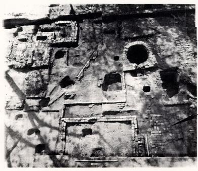 PHOTO 28. - Structure G
The first of a series of foundations re-excavated in 1984 was the remains of a building designated Structure G (Photo 28, above). From the James Knight map, drawn after the 1955 cross-trenching, the foundations appear to be those of a dairy. Unfortunately, due to the proximity of the Skillman- House foundations just to the east, the structure was never fully excavated.
The foundations measured ten feet north-south, and probably the same east-west, though the east wall has never been uncovered. The building lay predominately in unit 150N 40E, resting slightly askew of the surrounding buildings. Interestingly enough, however, it is parallel to the existing well-curb.
English bond was attempted in the northwestern corner of the structure. This, however, gave way to rowlock and finally to casual bonding as one moves southward along the western wall. The brick bats in the foundation were, of course, re-used, but the whole brick in the foundation appear to have been new at the time of construction. The foundations have been damaged and repaired in places, and damaged but not repaired in others. The brick used in the floor paving was made from both whole and partial brick, and has undergone extensive damage over the years.
134As is the case with the majority of the outbuildings at Peyton Randolph, Structure G had been separated from the surrounding stratigraphy by the early archaeological activities of the Foundation. Dating the construction and destruction of the building is therefore not easy. None of the artifacts recovered in or around the structure can be said to come from, or be related to, the structure in any way. Derivation of the function of the building from the artifacts is therefore impossible. The brick floor does not necessarily suggest that the building was indeed a dairy, nor does its ten by ten foot size.
The location of the building may reveal a relative date that the builder's trench (having been destroyed in the previous digging) could not. The building rested approximately within the eastern line of the eastern edge of the west wing of the house, as did Structures K and H. It is logical to assume that all of these buildings were constructed prior to the erection of the mid-section of the main house, i.e., around the mid-1760s. Whereas Structure K, part of the rather organic kitchen complex, probably did not survive the construction of the mid-section, Structures G and H apparently did. The Marl Yard Spread, also known as Marl Walkway # 2, was associated with the use of the latest kitchen (Structure L), and covered Structure K but not Structures G and H. Therefore G and H must have still been in use during the last kitchen period. Both buildings apparently survived into the early nineteenth century as the c. 1800 refuse layer brought in by either Hornsby or Peachy did not cover either structure. The last marl walkway (Marl Walkway # 1), which has a TPQ of 1820, did cover Structure G, indicating it was down by the mid-nineteenth century. Structure G was then either unnecessary or had been replaced by one of the other structures located in the 28B area (N, P, Q, or R). If Structure G had functioned originally as a dairy, it may have been replaced by Structure P. An early twentieth-century photograph (see Photo 30) shows two eighteenth-century style outbuildings in the back yard. One is apparently a smokehouse (probably Structure H), and the other is a dairy which appears to stand where the foundations of Structure P were uncovered.
V.H. STRUCTURE H - SMOKEHOUSE (?)
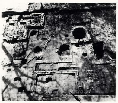 PHOTO 29. - Structure H
The foundation designated Structure H (Photo 29, above) is located approximately two feet south of Structure G in units 130N 40-50E and 140N 40-SOP. The building measures 12.4 feet north-south by c. 12.0 feet east-west (exterior). Well-fired primary-use brick, mortared with shell mortar in the English bond style, were used to construct the foundation. Compared with Structure G, the foundation remains were in excellent condition. Structure H was partially excavated during the 1930s archaeological investigation, then partially excavated again in the 1950s. The 1984 and 1985 excavations completely uncovered only the southern and western walls, leaving the northern and eastern walls only partially dug. Approximately half of the interior was excavated to subsoil. In addition to the four foundation walls, Structure H had a rather unusual appendage attached to the west side. The appendage consists of a row of brick (and one flat stone) laid on edge extending westward 2.3 feet from the southwestern corner, at which point the row brick extended northward eleven feet, where it again made a right angle, extending westward another six feet to the southeastern corner of the well-curb. The purpose of this rather strange addition to Structure H is unknown. The area between the brick row and the foundation walls was either enclosed, or had a special function because the stratigraphy inside the appendage was distinctly different from that outside to the west and from the interior of Structure H.
136STRATIGRAPHY - INTERIOR OF STRUCTURE H
Topsoil and sod overlay a grey brown layer, probably deposited by the grading of the Skillman lot after the razing of the house in the 1960s. This layer rested over Topsoil 2, which sealed a sandy loam containing coal, brick, and mortar. Under this layer of debris, a very dark greyish brown loamy sand containing large amounts of burned material (TPQ 1820) was uncovered. Below this layer of burned material a layer of very dark brown soil containing a great deal of artifactual debris was revealed. Artifacts in this layer included a Thomas Hornsby bottle seal dated 1769, several buttons, ceramics, and other domestic trash. The layer appears to have been deposited as fill and rendered a TPQ of 1820. It is similar, but a little later than, the Refuse Layer covering the Marl Spread just to the south of Structure H.
Two features were located within the interior of the foundations, one or both of which may represent post placement within the structure while it was still in use. One feature, 28H/535, was located almost directly in the center of the building. The other was located just to the north of 28H/535. Both features intruded a clay layer which may represent a floor level. Artifacts recovered from this layer included an iron lock, a pot hook, a fork, a small buckle, a sturgeon scute, bone, assorted ceramics, pipe bowl and stem fragments, etc.
Below the possible clay floor was a layer of brown mottled soil, then a layer of pink ash and rubble overlying another possible floor of loamy sand and clay (TPQ 1762),2 and finally a light grey mottled soil above subsoil.
From the stratigraphy described above and associated terminus post quem dates, several observations may be made. The building was constructed some time after 1720, and had a clay floor which was replaced after 1779. The presence of wood ash and a central pit or post may suggest the building functioned as a smokehouse at least part of its life.
APPENDAGE
Though almost separated from the surrounding stratigraphy by the archaeology of the 1930s and the 1950s, the odd rowlock appendage to Structure H did have a small section of its stratigraphic sequence intact. The brick were entirely covered by the usual layers of recent activity, i.e., topsoil, a driveway, cross-trench backfill, Topsoil 2, and a portion of the feature described as Marl Walkway # 1. Lastly, it was covered by the a circa 1820 refuse layer. The first layer stratigraphically unique to the interior of the appendage was a lens of pink ash, also with a TPQ of 1820. There were few artifacts in the ash—all of the usual domestic types—with nothing to indicate the function of the enclosure. Below the pink ash, however, a successive series of lenses with TPQ's of 1700 to 1765 were uncovered. None contained material of particular significance. The principal feature covered by these lenses was the builder's trench to Structure H, also covered at the southwestern corner by the appendage itself. As mentioned earlier, the builder's trench 137 one artifact, a sherd of pearlware (TPQ 1779). However, basing the construction date of the structure upon one artifact, which could have been mechanically displaced, is less than sound judgment.
The function of the arrangement of rowlock brick is not known. Possibly, since it does connect Structure H with the well, it represented only an edging for a small walkway. This does not explain, however, what became of the walkway base, though there was a lens of marl which may be the last fragment of evidence for such a path. The successive lenses within the interior of the appendage may indicate the area enclosed by the rowlocks was not protected from the elements.
 Photo 30 - Surviving Outbuildings Behind the Peyton Randolph House, circa 1900
The edging may have also been associated with a work area for the forge (?) attached to the north hearth of Structure J. The area bounded by the forge, the appendage, the well, and the chimney base seems to denote a roughly square open area. Unfortunately, the stratigraphic sequence in this area was extremely disturbed, not only by previous archaeological investigation, but by a recent driveway which traversed the area until the 1960s, and a hedge between the Ball and Skillman properties. Remains in the area did include a southeast-northwest diagonal ditch which was filled in the late eighteenth or early nineteenth century, a recent pit, and a number of ash layers—together creating nearly a foot of fill in some places.
Structure H appears to have survived into the early twentieth century. A photograph (Photo 30, above), taken around 1910, reveals two possible eighteenth-century outbuildings behind the Peyton Randolph House. Structure H is believed to be the smokehouse located between the windmill and the dairy (Structure P?).
V.J. STRUCTURE J - DWELLING/SECOND KITCHEN
 PHOTO 31. - Structure J
Structure J (Photo 31, above) is probably one of the oldest and most enigmatic buildings excavated in the 28H area. The layout and extent of the structure has been a topic of a great deal of discussion among architectural historians and archaeologists. Included in this descriptive analysis of Structure J are several foundation walls, either truncated, subsequently built upon, or robbed out. The most rudimentary part of the foundation consisted of two east-west walls eight feet apart, constructed both in casual and rowlock bond. A thirteen-foot north-south wall connected the two on the eastern side, and it also reflects the two different types of brickwork. A similar wall to the west was displaced by a walnut tree and was not excavated because of fear of damage to the tree. These four walls would enclose an eight by eleven foot room or parlour entrance. The thirteen-foot eastern wall was later truncated by the construction of the Structure L double hearth, though remnants of a south wall for Structure J exist along the north edge of the vaulted cellar. Together, these walls would indicate another room south of the parlour measuring approximately eleven by eleven feet square. North of the parlour entrance room, there appears to have been a small room measuring approximately ten feet north-south by eleven feet east-west, containing a five by 139 eight-foot interior hearth. Forty of the 110 available square feet in the room was taken up, therefore, by what appears to be a cooking hearth. Apparently, not too long after the construction of the building, a six foot wide lean-to was built on the east (back) side of the structure. Whether the lean-to ran the entire thirty-two foot length of the building initially is uncertain, but it appeared to do so in later phases of the structure's life.
Structure J grew organically over the years. The interior hearth was abandoned, and an exterior hearth and an oven was constructed on the north elevation. Later, the fourteen-foot-square room designated as Structure K was added on to the building, making an L-shaped kitchen with two hearths and approximately 775 square feet of work space. Additionally, at some time in the eighteenth century, what appears to be a forge was added to the northwestern corner of the second (exterior) chimney base to Structure J. Finally, Structure J was incorporated into Structure L, the last free-standing kitchen to serve the Peyton Randolph House. Whether the, hearth and oven at the north end of the structure remained in use with the building of the large new kitchen is unclear. All archival photographs showing the back yard of the house in the last century were taken from such an angle that the northern part of the kitchen is obscured.
Hearth 1 in the north parlour of Structure J was uncovered in the 1938 excavation. Judging from the brickwork, James Knight gave it a relative date of construction as "first period," along with the main body of the structure. The hearth appears to have been placed in the northeastern corner of the room. Unlike the corner hearth in Structure A, whose firebox was at an angle to the walls of the room, the hearth in Structure J is parallel to the north wall. According to the 1938 map resulting from the archaeology, the hearth was covered with several inches of ash above the brick paving of the firebox, and contained six inches of ash below the brick paving. Unfortunately, nothing is known about the artifacts, if any, recovered from either above or below the paving. None were found in the 1984 excavations. The only layer associated with this hearth appears to be a lens of ash partially inside and extending southward. This deposit is more likely associated with the second hearth. Found in the ash, aside from the creamware which gave it a TPQ of 1762, was a commemorative shoe buckle from Admiral Vernon's victory over the Spanish on November 22, 1739 (Figure 60).
 Figure 60 - Admiral Vernon Commemorative Buckle
A small (2.6' interior diameter) oven was discovered two feet east of the later hearth. This oven was the only significant brick structural feature not included on the Knight map following the 1930s excavations. Though intruded later by a modern driveway, it appears the round oven on its five foot square base was at least partially uncovered during the 1930s excavations. Apparently, the foundations were inadvertently left off the map. The layer covering the oven had a TPQ of 140 1880, indicating a possibility that the chimney and oven stood above ground as long as the rest of Structure L.
The small, northernmost hearth or forge built onto the northwestern corner of the second hearth to Structure J measured approximately 5.5 feet east-west and 6.5 feet north-south. The brick was in good condition and appeared to be set in English bond. Ash in and around the hearth has a TPQ of 1762. Exactly what the forge was used for is not known, though small tool repair forges are not unusual, even on urban sites. No slag or melted metal was found in association with the hearth, however. Among the unusually prolific domestic items recovered from the ash layer associated with this forge were 114 nails.
V.K. STRUCTURE K - THIRD KITCHEN
 PHOTO 32. - Structure K
Structure K (Photo 32, above) was actually an addition to Structure J, probably replacing the former Structure M kitchen some time in the late 1730s or early 1740s. Exterior dimensions are square, 17 feet by 17 feet. It contained an interior hearth along the center of the east wall, with a firebox six feet long and 3.5 feet wide. Placing the hearth in the interior caused two 2.5 foot spaces on either side of the chimney. These spaces could have been ovens, though no evidence of this possibility remained archaeologically. The structure was built from highly-fired, dark-colored brick, incorporating a large number of bats in construction. Both the north and south walls were interrupted about halfway by two post holes from a later fence line. The structure had been fully excavated, in the 1930s, thereby separating it from the surrounding stratigraphy, except in one small area. A layer of undisturbed brown loam [TPQ 1762] lay over a small portion of the southeastern corner of the structure. In addition, layers which existed both on the interior and exterior of the structure, such as the Marl Spread described earlier, had TPQ dates of 1779.
142The hearth inside Structure K had been left fairly well intact by the earlier archaeology, and was fully excavated in the 1984 season. The first layer in the firebox consisted of highly-burned brick, under which were successive lenses of ash and sand. Artifacts recovered from the firebox had a TPQ of 1720. The fill soil and subsoil below showed signs of prolonged and intensive heat, i.e., the soil was varying shades of red and purple. The floor in the structure was probably earth, as the hearth was not elevated and signs of burning extend over a foot into the interior of the structure. A layer of yellow clay [TPQ 1720] just above subsoil was found over part of the interior. This may have been the remains of the kitchen floor. No other features associated with Structure K were located.
V.L. STRUCTURE L - FOURTH KITCHEN
 PHOTO 33. - Structure L
"Structure L" is the designation given to the last exterior kitchen to serve the Randolph House, constructed by Peyton Randolph during the 1760s. The remains (Photo 33, above), first uncovered in the 1930s excavations, included a vaulted cellar with a bulkhead entrance, massive support piers, a double chimney base, and support piers for a covered way leading to the back door of the main house. The parts described were built onto already-existing foundations, those of Structure J, resulting in one multi-purpose building some 48 feet long (north-south) and 20 feet wide (east-west). Undoubtedly Structure J was radically altered, if not completely razed, during this major building phase. Describing Structure L part-by-part will facilitate understanding the whole structure.
THE VAULTED CELLAR
The vaulted cellar was not completely excavated in the 1930s investigation of the back yard. It was, however, the first part of the building excavated in the 1984 field season. The cellar had been used as a cistern until the 1920s, and, from recollections of a past resident, was above grade and fitted with a hand pump for water retrieval. After city water was introduced to the area in the early 1920s, the vaulted top of the cistern was knocked down to grade and the entire eleven by thirteen by five-foot deep cistern was used as a trash receptacle. An enormous amount of trash [TPQ 1926] was removed from the cistern in the summer of 1984. An analysis of that trash is included as Appendix 11.
When the original cellar for Structure L was converted to a cistern (probably in the later part of the last century), a one-half to one inch coating of cement was put over the brick on the interior to make the cellar watertight. The original floor, which was probably brick, was removed and a depression dug into the subsoil in order to create a catch basin for debris which may have worked itself into the 144 cistern. The floor was then covered with a one to one and a half inch coating of cement. The cement used on the walls and floor was very fine-grained, adhering all too well to the porous eighteenth-century brick. Approximately half of the cement was removed by the archaeologists in the 1984 excavations with hammer and chisel in order to expose the original brickwork on the interior of the cellar. The vaulted ceiling of the cellar had been largely destroyed when the cistern was leveled and filled in the 1920s; however, extrapolating from what remained, the interior apex of the cellar ceiling was approximately 5.1 feet above the cellar floor. The vault was constructed of rather soft, dark red brick two courses thick set in English bond. The curved walls of the vault were set on two straight walls seven courses high. The east support wall for the curved vault was about three feet thick, supporting three massive piers on the exterior of the vault. The western support wall was 1.5 feet thick, also supporting three similar smaller piers. At the south end of the cellar, was a 3.3 foot wide, seven step bulkhead entrance. Each of the steps had wooden nosings when constructed, but had long since deteriorated. The bulkhead entrance extended six feet to the south of the south wall of Structure L. Constructed of brick which is the same color and hardness as the main walls of the structure, the entrance was not, however, mortared into the cellar wall, but abutted it as if constructed later. The bulkhead was centered along the cellar's south wall, but was off-center to the west relative to the whole structure.
The east interior wall to the cellar was located 4.5 feet from the interior of the east wall of the main building. The western interior wall was located only 0.6 feet from the western interior wall of the main structure. The cellar was apparently constructed off-center to allow for the covered way which extended towards the main house from the southeastern corner of Structure L.
Removal of the cement from the floor of the cellar revealed several notable features. Located at the foot of the steps was a large (4.0' diameter) circular feature (28H/119) some 4.1 feet in depth. Artifacts recovered from the feature fill indicate that the hole had been filled some time after 1880, probably when the cement floor was added. The bottom of the feature was circular and flat. Though not indicated in the artifactual remains, the hole may have contained a barrel and functioned as a sump to catch water coming down the steps in rainy weather. A thin layer of fine mortar was also found around the edges of the interior of the cellar. The mortar probably extended over the entire floor as a base for the original brick paving. The mortar was destroyed, however, when the floor was removed and the settling depression was dug out for the cistern. Several smaller features intruded the mortar base, most of which were shallow and seem to represent driven stakes (Photo 34). The stakes may have been used to support shelving or bins for vegetables or wine. Unfortunately, no datable artifacts were recovered from any of the features excavated.
DOUBLE HEARTH
A large base for an "H"-shaped double-hearthed chimney was uncovered abutting the north wall of the cellar. The base had exterior dimensions of 8.4 feet north-south and 11.4 feet east-west, containing two 3.3 foot by 7.7 foot fireboxes. The chimney was placed directly in the center of the north wall of the cooking room, 3.3 feet from both the eastern and western walls of Structure L. All of the chimney base walls were 1.8 feet in thickness. Bonding style was an attempt at
145
 Photo 34 - Vaulted Cellar, Cement Removed
English bond, with substantial use of brick bats. Given that the floor of the cooking room was directly over the cellar and therefore must have been raised at least two to three feet above ground surface, the fireplace on the southern half of the double hearth was several feet above the elevation uncovered during the excavations. This is substantiated by the fact no ash or burned material was found within the interior of either hearth. Building of the hearth also resulted in the truncation of the north wall and the interior east parlour wall of Structure J.
EAST WALL
Excavation of area between the vault and support piers and the east wall of the structure revealed a great deal about how Structure L was constructed, as well as posing new questions about why it was constructed the way it was. The area was bounded by the vault wall to the west, the main walls to the east and south, and a short (three-foot) wall added between the wall the hearth abutted and the east main wall. Fill in the six by thirteen and a half foot area was over four feet deep in places.
The fill was a mixture of clay and redeposited subsoil, probably excavated from the cellar. Though the well-packed fill seems to have been deposited shortly after the building was constructed, there were no significant datable artifacts recovered.
At the bottom of the clay and subsoil fill, the top of a brick wall was encountered. The wall was approximately three feet wide and two feet high, running the length of the cellar vault. This is the same straight wall upon which the vault was constructed and the three large piers rested. Though laid in English bond on the interior of the vault, the majority of the wall was made of 146 randomly-bonded, heavily-mortared brick bats. The mortar was so thick in places that it appears to have been poured on each course of brick rather than having been spread with a trowel. This support wall began approximately three feet west of the east wall of the main structure at about the same elevation as the bottom of the east wall. The three large support piers resting on the vault wall were all three feet east-west on top, following the curvature of the vault to the top of the support wall. The eastern central pier was three courses wide (2.2' north-south) and the southeastern and northeastern piers were two courses wide (1.5' north- south). All were well-constructed and the mortar joints carefully pointed.
 Photo 35 - East Wall
The east wall of Structure L was very unusual in one respect: for a length of ten feet north from the southeastern corner, the wall had thirteen courses intact. Ten feet from the corner, the wall was only four courses high (Photo 35, left). Apparently, the subsoil was dug out only enough to facilitate construction of the vault, making it necessary for most of the east wall to have been constructed deep into subsoil. The south wall of Structure L was also built in two levels: thirteen courses in the southeastern corner, to twenty at the beginning of the vault support wall. Most of the builder's trenches for the south and east walls were left intact by the 1930s excavations. No significant finds were made; indeed, the lack of creamware in the excavated builder's trenches is more significant than the presence of white salt glazed stoneware and delft.
The western structure wall and support piers were significantly different from their eastern counterparts. The piers were somewhat smaller than the piers on the east side. All three were the same size, 1.5 feet square at the top. They were also constructed with less care than the eastern piers, probably because of the tight space (0.6') between the vault wall and the western wall of the structure. The east side of the building does, however, hold the key to the question of whether or not the vault and the remainder of Structure L were indeed constructed at the same time. Two modern post holes, created by Colonial Williamsburg, were drilled into the western wall of the structure, making a rounded but cleanly-cut section through the northwestern pier, the west wall, and the straight wall upon which the piers rested. This section showed that the west wall and the straight wall were actually the same wall, which was built narrower at the top to accommodate the brick piers. The cellar and the structure walls were therefore constructed simultaneously.
Another area of Structure L investigated rather closely was the juncture of the cellar wall, the west wall, and the remnants of the older Structure J wall (Fig. 61). The northwestern exterior corner of the cellar extended twenty courses (4.7')
147
 Figure 61 - Exterior, Northwest Wall, Structure L
148
from top to bottom. The northward extension of the west wall from this point was but three courses deep and a brick and a half wide. The outer half-brick was added to an already existing one brick-wide, Flemish-bond west wall of Structure J. This provides the principal evidence that Structure L was an addition to an already-existing structure, though with significant alterations.
Figure 61 - Exterior, Northwest Wall, Structure L
148
from top to bottom. The northward extension of the west wall from this point was but three courses deep and a brick and a half wide. The outer half-brick was added to an already existing one brick-wide, Flemish-bond west wall of Structure J. This provides the principal evidence that Structure L was an addition to an already-existing structure, though with significant alterations.
THE COVERED WAY
The only mention of a covered way presumably connecting the kitchen with the main house is in Humphrey Harwood's 1777 ledger where he has charged to Betty Randolph's account on June 3rd: "To Mending Lathing & plasterg in Kitching & Covered way 15/. & hair 9d —-" (from Stephenson 1952). What is believed to be that covered way is represented archaeologically by a parallel line of brick piers extending from the southeastern corner of the kitchen thirty-five feet to the rear of the main house (Fig. 62, left). The eastern row of piers and the western row were seven feet apart, center to center. Though all of the piers were excavated during the 1930s excavations, only three were uncovered during the 1984 season; the remainder were too near the house and excavation would have severely disrupted the flow of visitors through the house. Two of the eastern line piers were 1.5 feet square, similar to those used to support the floor in Structure E. The other was a one course thick double row of six and one half bricks extending 2.5 feet from the south wall of the kitchen. This pier was located, along the exterior south wall 1.1 foot east of the bulkhead entrance. Little else is known about the covered way. It may be conjectured that it was built at the same elevation as the floor of the house and the floor of the kitchen so that the server would not have to negotiate any steps with a tray loaded with Peyton Randolph's dinner.
 Figure 62. - Remains of Piers Supporting Covered Way
PORCH APPENDAGE
Along the east wall of Structure L, beginning five feet from the southeastern corner, a stair support or porch was constructed. The rectangular base was of mainly-whole brick in English bond, measuring 12.2' north-south by 6.2' east-west. The short north and south walls were two feet wide and the east wall only one foot 149 in width. The north wall was built over the south wall of Structure K. This porch addition was not contemporary with the construction of the kitchen, but was probably added some time in the early nineteenth century. It was constructed on the Marl Spread discussed in detail elsewhere in the report. The spread yielded a TPQ of 1779. The remnants of a walkway leading from the porch to the central marl walkway was excavated in the adjacent units to the east.
 Photo 36 - Circa 1870 Photograph Showing Kitchen Building Behind Main House
SUMMARY
Structure L was an extremely complex and at times an enigmatic, grouping of foundation walls with additions and restructuring of older buildings. In its final state as Peyton Randolph's kitchen it contained three fireplaces, an oven, a cellar, and a covered way. The living and working space was at least on two levels; the floor of the cooking kitchen over the vaulted cellar was two feet or more above the floor in the north (old Structure J) rooms. Whether or not the building was at least in part two stories, as many people believe, is addressed in the architectural section of the report. Williamsburg Land Tax Records from 1818 assess Thomas Peachy, Jr. $30 for the building described: "Via Mary M. Peachy, house and lots which she has hitherto occupied as a kitchen, laundry, and quarter for her servants, being north of the west [of] her dwelling house and formally charged to Thomas Peachy's Estate." Assuming the building was in 1818 much as it was in 1770, it was almost assuredly two floors in order to have ample space for all of the activities described in the tax records. Surviving photographs from the last century show a much-altered Structure L with board-and-batten siding. However, the massive chimney is virtually unmistakably the one for which the base survived. Unfortunately, all of the photographs were taken from the south, so the northern part of the building is obscured. One old photograph (Photo 36, previous page) does show, however, what appears to be an eave of a single-story wing on the north end of the structure, perhaps indicating that the building was multi-level.
V.M. STRUCTURE M - FIRST KITCHEN
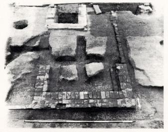 PHOTO 37. - Structure M
The foundations designated Structure M actually consisted of only a brick chimney base and a ten-foot line of badly weathered rowlock brick extending northward off the northeastern corner of the hearth foundations (Photo 37, above). No other walls or associated post holes were located in the 1930s or 1980s excavations. The hearth measured 9.8 feet east-west across the back or southern side, and 4.75 feet north-south along the east and western sides. The interior of the firebox was six feet east-west and 3.5 feet in depth (north-south, interior). The east-west chimney base wall was 1.6 feet wide, and the two north-south walls were 1.2 feet wide. The bonding of the brick was with good-quality shell mortar in a somewhat casual English bond style. The bricks in the chimney base were well-fired and in reasonably good condition, in contrast to the line of rowlocks extending from the above-mentioned northeastern interior corner.
Extending westward 2.2 feet from the southwestern exterior wall were three single-course bricks laid end-to-end in a similar fashion as those brick which made up the facade between piers in Structure A. No corresponding row of brick survived on the southeastern exterior corner. If these brick, and the rowlocks described above, were indeed the remnants of the foundations for Structure M, the fireplace was again located in the corner of a room parallel to the walls as is the case with the first hearth in Structure J. Also, the wall extending northward from the hearth in Structure M and the wall abutting the eastern edge of the first hearth in Structure J were both poor in quality, similar in color, and laid as rowlocks. Both of the structures were interpreted as from the same time period (early colonial) when first uncovered in the 1930s, probably because of the similarities described above.
152Unfortunately, Structure M was so separated from the surrounding stratigraphy and there was so little of the building remaining, that it is impossible to determine exactly when it was built. The archaeological report on the 1930s excavations (Duke 1939) mentions Structure M only briefly. Structure M was probably the first kitchen for the house, given its location of only twenty-seven feet north of the main house, and its large six-foot hearth. It, along with Structure J, appear to be the only support buildings near the main house built in the same time period as the house itself.
Not only is the construction date of Structure M obscured by the lack of stratigraphic correlation, the destruction period is also somewhat vague. The building was most certainly down by the time Structure L was constructed (1760s), and it was likely down by the time Structure K was added to J (late 1730s or 1740s).
The 1985 excavation of Structure M took place during the summer and was accomplished by one full-time crew member, who was both interpreting the site to visitors and conducting a field school while digging. The excavation of layers which may have related directly to Structure M was not completed. Artifacts recovered from the layers that were dug were few and not generally informative. Little evidence of burning inside the hearth was encountered, unlike the hearth in Structure K which contained a great deal of ash. Even the subsoil under the ash in the interior of Structure K's hearth was burned to a depth of several inches. Either the firebox in Structure M was higher than that in K, or there was shorter and less intensive use of the kitchen.
V.N. STRUCTURE N - SHED
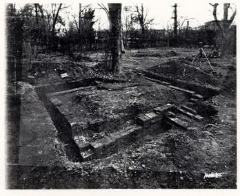 PHOTO 38. - Structure N
The foundations of Structure N (Photo 38) were the only outbuilding foundations located during the 1930s excavations from which a reconstruction was based. The presently standing 10 by 14 foot shed was built where a foundation with a brick bat-paved floor was uncovered. It appears the footings for the original building were removed and a new foundation built for the reconstruction. The present building served as a kitchen for the Ball family when the kitchen addition they had been using was torn off the main house and a new kitchen was being built for them in the reconstructed east wing (Gertrude Deversa, personal communication). Indeed, a fork from Mrs. Deversa's grandmother's silver flatware service was found by the excavation crew when cleaning the shed for use as a field office. The piece was returned to Mrs. Deversa.
The only clue about the original foundations for Structure N comes from Duke's Archaeological Report:
Separated by 3 feet from the nearest storehouse foundation and by 13 feet from the marl walk, remains of another outbuilding were found opposite the southeast addition to the second kitchen. Four 9-inch walls were traced, defining a building which measured about 10 x 14 feet. Paving of brickbats was found inside. Earlier work under parts of the north and east walls indicates that the building was destroyed and rebuilt on the same site, or perhaps that the same building was raised to a higher level.
154Two short 9-inch foundations project from the west wall south of center but are not bonded with the wall. They may have supported a small stoop, or a narrow flight of steps.
The brickwork in this foundation is of as early character as that in the first storehouse foundation. The east wall of this foundation lines with that of the third storehouse. Hence, the life of the building or buildings here indicated may have spanned that of all three storehouses.
This building cannot be positively identified but it may be the shed mentioned in Humphrey Harwood's accounts for 1777 (Duke 1939:10-11).
The storehouses to which Mr. Duke was referring are three buildings (Structures P, Q, and R) superimposed on one another. He also mentions in a footnote that he believes one of the four buildings in the group of structures east of the marl walk was built before the property had been amalgamated in 1723-24. This is based on the position of two resting just west of the lot line. Mr. Duke did not have knowledge of the long-maintained fence line along the lot line which divided the back yard from the time of the construction of the two houses to the eventual destruction of the "east wing" some time in the early nineteenth century. With this knowledge, the position of the outbuildings may relate less to the lot line and more to an endeavor to make the back yard somewhat more symmetrical after having added the mid-section of the main house. It is doubtful, though possible, that any of the four buildings were built before the construction of the mid-section, probably in the 1750s.
V.P. 28B AREA
Five ten-by-ten foot excavation units (70N 70E, 70N 80E, 60N 70E, 60N 80E, and 50N 80E) were opened in the area between the reconstructed shed (Structure N) and the main house, east of the central marl walk. No structural foundations were found and no features dating earlier than 1850 were encountered.
The remnants of a mortar and brick bat walkway were uncovered under Topsoil 2. The walkway ran north-south along the eastern edge of units 60N 70E and 70N 70E into the adjacent units. The walkway appeared to have been about four feet wide with brick bats laid over a marl base. An east-west marl walkway located in the central section of unit 50N 80E, also approximately four feet wide, apparently intersected the north-south walk at the same stratigraphic level, i.e., sealed by Topsoil 2. It is unknown what traffic these walkways served.
This area was also highly disturbed by utility lines and sewer pipes. A pipe, which is probably a water line, runs north-south through units 70N 70E and 60N 70E about four feet east of the 70E grid line. Another pipe or electric conduit runs diagonally through the very northwestern edge of unit 50N 80E, across 60N 80E, into the southeastern corner of 70N 80E. In addition to the two utility lines, a series of out-of-service ceramic drain or sewer pipes crosses the area. The longest pipe runs from the edge of excavation at 56.5N 70E east-southeast to the edge of excavation at 52N 90E. This pipe is cut twice by the utility lines. Another small segment of sewer pipe was located in the extreme southwestern corner of 60N 70E, and another in the southwestern corner of 50N 80E. This line may have been connected to old down-spouts from the main house. No other significant features were found in this section.
Another section known to contain brick foundations was opened north of the reconstructed shed. The area between 135N 75-95E and 100N 75-95E contained the remains of three structure foundations superimposed on one another—Structures P, Q, and R (Photo 39).
STRUCTURE R - UNIDENTIFIED BUILDING
The oldest of the three foundations, Structure R, had exterior measurements of 16 feet north-south by 8 feet east-west. Remnants of a brick-paved floor extended over the northern three-quarters of the building. Another east-west wall ran across the interior of the building three feet north of the south wall. It was between this interior wall and the north wall that the paving was placed. No paving existed between the interior wall and the south wall. The interior and exterior walls of Structure R were all one brick wide and laid in English bond. The east wall of Structure R was missing except for five bricks on the southeastern corner.
STRUCTURE Q - UNIDENTIFIED BUILDING
All that remained of the middle-period building, Structure Q, was an "L"-shaped wall, the longer (22.2') west wall of which was built partially on top of the west wall of Structure R. The shorter south wall measured 7 feet. This structure was built of mixed brick and brick bats in no particular bond. Soil under the wall contained no datable artifacts.
156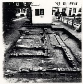 Photo 39 - Structures P, Q, and R
STRUCTURE P - DAIRY
Structure P was a later two-room building with overall exterior dimensions of 19.2 feet by 12.2 feet. The interior of the larger southern room was 10.7 feet north-south by 10.2 feet east-west. The smaller northern room measured 6.2 feet north-south by 10.2 feet east-west. Construction was done in casual bond using mixed brick and brick bats. No east wall was found for the smaller chamber. The north wall of Structure P had slumped considerably. The artifacts excavated beneath the east wall of Structure P have a TPQ of 1779. A early twentieth-century photograph (see Photo 30, page 137) shows an eighteenth-century style dairy building at or near the same location as the foundations of Structure P. It appears that this structure, along with a smokehouse, Structure H, survived until the first or second decade of this century. Both were obscured by Structure L in earlier photographs and do not appear in a later, c. World War I-era photograph (Photo 27, page 116).
SUMMARY
Artifacts recovered from the area of the three buildings did not indicate any specific function attributable to the structures.
Associated with the three structures were three marl or rubble walkways, also built on top of each other. They apparently connected the structures to the main walkway, nine to eleven feet to the west of the structure. Only the latest walk contained datable artifacts, with a TPQ of 1820.
157The only other significant feature found in this section of the 28B area was the continuation of the seventeenth-century boundary ditch first located in the Structure A area. Again the ditch was at the lowest stratigraphic level and contained no artifacts.
V.S. THE WELL
 PHOTO 40. - The Well
The Randolph House Well (Photo 40) was located in the northeastern quadrant of unit 140N 20E and the northwestern quadrant of 140N 30E, approximately twenty feet north of the exterior hearth for Structure J. The interior diameter of the roughly circular well shaft was about four feet. Apparently a good water source, the well was used until 1920, but had been completely filled by the time the Skillman House was constructed in 1924. As wells were commonly cleaned of debris while in use (Noël Hume 1969a), it is not likely that any material relating to the Randolph occupation of the property would be recovered by digging. Recovery of debris from this century would not yield information sufficiently important to risk the endangerment of the excavators or the expenditure of the large amount of money inherent in well excavation. The depth of the well is therefore unknown.
The well was first uncovered in the 1955 cross-trenching of the Skillman's front yard. It was drawn and photographed by Mr. Knight at that time. No other wells have been located on the Randolph property. Either this well served the house and kitchens since the early eighteenth century, when the buildings were constructed, or water was carried from a nearby spring located on lot # 185 (as numbered on the Bucktrout Map). Another well may have been located near the stables, which are believed to be near Scotland Street some 500 feet north of the house.
The well was not constructed of the usual wedge-shaped well brick, but of ordinary rectangular building brick. The five foot square well-curb was added to the original well sometime after its construction. The curb may be the result of Humphrey Harwood's repair of the well, noted in his ledger of August 19, 1785.
159A single row of brick—different in color and hardness from those used in the well—extended eastward from the southeastern corner of the well curb, six feet from where it makes a right angle southward eleven feet, then eastward again for three feet, intersecting the southwestern corner of Structure H. The purpose of this row of brick or "appendage" is unknown. Whether it was associated with the structure or the well (or both) has not been determined.
The well-curb and Structure G are on parallel lines with each other, but with none of the rest of the outbuildings in the 28H area. This orientation may be a result of Harwood's repairs, but why it was done is wholly conjectural.
The well was excavated to a depth of 4.5 feet during the most recent excavations, approximately a foot and a half beyond the depth excavated in 1955. This was done to make certain the fill contained primarily only artifacts from this century, which was indeed the case.
160CHAPTER SIX:
INTERPRETATION AND CONCLUSIONS
The premise which guided the most recent archaeological investigation of the Peyton Randolph Lot was based on the supposition that changes in the ownership or "control" of the property would be reflected in the archaeological record. These periodic changes may have affected the placement and/or function of the various outbuildings as well as the landscape of the back yard. In order to best illustrate this premise, a periodization approach to the interpretation of the findings was developed. Thirteen periods were defined, extending from the Middle Plantation Era until the present. Within each period there is an attempt to show the changes which occurred physically in the back lot and in the main house and how these changes reflected the social and economic standing as well as the world-view of the owners.
Each period was "chosen," partly by the archaeologists responsible for interpreting the use of the property through time, and partly by historical events involving the area in general or the residents of the Peyton Randolph House in particular. Each period summary attempts to show specifically those changes, intentional or unintentional, that are thought to have taken place on the property during the temporal span defined by the period.
The primary function of all of the archaeology that has taken place on the Peyton Randolph property in the last forty-seven years was to provide information relevant to the reconstruction of those outbuildings in use at the specific time period the Colonial Williamsburg Foundation deemed the most appropriate for historical interpretation to the public. Although period reconstruction is necessarily a "quick time" view1 (Binford 1981) of the archaeological and historical record, the dynamics of human behavior cannot be over-looked, but are-indeed essential to the understanding of many aspects of everyday living in past times.
Each of the following thirteen periods will be defined and their relevance explained. The archaeological features, how they change, and how these changes are related to other physical, historical, and social changes are summarized in each period.
1621. PRE-1699 (Fig. 63)
This period could as easily be divided into two sections, examining separately pre-1699 English colonial activities, specifically the Middle Plantation settlement, and the activities of the aboriginal people inhabiting the area for the several thousand years before the English. However, the prehistory of Tidewater Virginia is quite beyond the scope or intention of this report. Indian remains specific to the Peyton Randolph back lot were virtually non-existent. Even the Middle Plantation Era, beginning in 1622 and lasting until the establishment of Williamsburg as the colonial capital in 1699, was represented only scantily on the lot.
Aside from a few residual or displaced projectile points and pottery, no aboriginal artifacts or features were located during the archaeological excavations of the 1930s, 1950s, or 1980s. The only reference to aboriginal remains is in the 1952 Architectural Report of the Randolph-Peachy House: "Indians are buried on the east side of the yard. Mr. Chorley and Mrs. Ball both agree they should not be disturbed" (Kocher and Duke 1952:69). The "east side" apparently refers to the area directly in front of or behind the reconstructed "east wing" of the Peyton Randolph House. The statement was made on July 12, 1938, before the east wing had been reconstructed, and before the National Park Service built the Colonial Parkway tunnel under the Historic Area. Sources for the information regarding the alleged burials are unknown, and no archaeology, other than uncovering the foundations of the so-called "east wing," has taken place in that part of the yard. Construction of the tunnel in 1940 disturbed much of the east side of the yard (and the newly reconstructed "east wing"), as illustrated in Photo 41 (above right). If the graves existed, they may have been destroyed at this time.
 Photo 41 - Effects of Tunnel Construction
The only discernible Middle Plantation Era feature represented at the Peyton Randolph site was a drainage or boundary ditch which traversed the site from the northwestern edge of excavation to the area near the east-central edge. The northern and southern extents of the feature were not determined. The four-foot-wide trench was partially excavated in the 28G area of the site, but yielded no
163
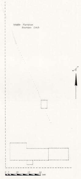 Fig. 63 - Periodization Map 1 - Pre-1699
164
significant or even datable artifacts. The feature was found at the lowest stratigraphic level, intruding only sterile subsoil. This fact, and the observance that the feature was not oriented in the usual north-south, east-west plan as are most Williamsburg Era features, place the ditch in the pre-1699 period. The lack of known orientation of the ditch to anything but the landscape may reflect a seventeenth-century attitude in which man adapts to the landscape, rather than attempting to impose order on the landscape as was done with the establishment of the City of Williamsburg with a gridded town plan.
Fig. 63 - Periodization Map 1 - Pre-1699
164
significant or even datable artifacts. The feature was found at the lowest stratigraphic level, intruding only sterile subsoil. This fact, and the observance that the feature was not oriented in the usual north-south, east-west plan as are most Williamsburg Era features, place the ditch in the pre-1699 period. The lack of known orientation of the ditch to anything but the landscape may reflect a seventeenth-century attitude in which man adapts to the landscape, rather than attempting to impose order on the landscape as was done with the establishment of the City of Williamsburg with a gridded town plan.
2. 1699-1715 [No Map]
This period was chosen in order to represent the time between the establishment of the City of Williamsburg and the first recorded purchase of the lot under investigation. During this time period, the lot was owned by the city and no apparent activity took place that would leave its mark in the archaeological record.
3. 1715-1724 (Fig. 64)
Lot 207, presumably the lot excavated, was sold by the city to William Robertson in late 1714 along with several other lots. In all likelihood it was Robertson who built the main house, Structure J, Structure M, and Structure A. It is not known whether Robertson lived on the lot or rented to tenants. Structures A, J, and the main house all appear to be dwellings rather than dependencies, however, and Robertson probably rented all three structures to tenants. The tenant in Structure A constructed at least two of the four planting beds uncovered near the building during this period. The main house was definitely the grandest of the three structures, probably having an exterior kitchen (Structure M). Structure J was a rather rude hall-and-parlour structure, which would have probably been less out of place architecturally in mid-seventeenth century Jamestown than in early Williamsburg. Structure A was a simple structure built on brick piers over the Middle Plantation ditch described earlier. All three buildings had fireplaces in the corners of the rooms rather than along a wall, as was more common.
John Holloway, an entrepreneur from Norfolk, purchased lots 237, 236, 207, and 208 from William Robertson in 1723. At that time the lots already contained houses, an orchard, and a windmill (Stephenson 1952). It is doubtful that Holloway changed much on Lot 207 because he sold it to John Randolph only six months after he bought it. According to the York County Deeds and Bonds, John Randolph lived adjacent to the lot he purchased from Holloway at the time of sale. This is presumably lot 237, and the house in which he may have lived was Structure S, the so-called "east wing" of the restored Peyton Randolph House. When Randolph acquired lot 237 is unknown.
Physical evidence recovered, placing these buildings in this 1715-1724 period, is adequate if not substantial. Dendrochronological dating of the rafters and joists in the main house place its construction date at 1718 (A.I.D. 1983). Structure A was erected on a virtually sterile "A" horizon which appears to be the topsoil which existed before any Williamsburg related activities began. It was also constructed over the Middle Plantation ditch which apparently had not yet been filled because a support wall had to be placed across the ditch in order to rest the southwestern
165
 Fig. 64 - Periodization Map 2 - 1715-1724
166
pier of Structure A on a solid footing. Structure D, probably a small service building relating to Structure A, was constructed during this period as well. Structure J's rudimentary architecture, and the evidence of its having been expanded several times during its existence, place it in this early period as well. Structure M is assigned to the early period principally because of the placement of the chimney in the corner of a (the?) room as in the other structures. Also, the hearth size seems to indicate a cooking or kitchen function. Structure K served this purpose in the late 1730s or early 1740s, and Structure L immediately after that. Structure M, which is truncated by Structure L, must logically pre-date that building, and probably Structure K as well. It is an obvious candidate for the earliest kitchen on the lot. For these reasons, and that the structure appears to have been of post construction, Structure M can most likely be seen as contemporary with A and J.
Fig. 64 - Periodization Map 2 - 1715-1724
166
pier of Structure A on a solid footing. Structure D, probably a small service building relating to Structure A, was constructed during this period as well. Structure J's rudimentary architecture, and the evidence of its having been expanded several times during its existence, place it in this early period as well. Structure M is assigned to the early period principally because of the placement of the chimney in the corner of a (the?) room as in the other structures. Also, the hearth size seems to indicate a cooking or kitchen function. Structure K served this purpose in the late 1730s or early 1740s, and Structure L immediately after that. Structure M, which is truncated by Structure L, must logically pre-date that building, and probably Structure K as well. It is an obvious candidate for the earliest kitchen on the lot. For these reasons, and that the structure appears to have been of post construction, Structure M can most likely be seen as contemporary with A and J.
The appearance of the lot during this early Williamsburg period reflects a less gracious and affluent arrangement than exhibited in later times. With the recent movement of the capital and all of the government of the largest American colony to a newly-established town, housing was probably scarce and at times less than luxurious. Money could be made by those who could afford to buy land and build anything, no matter how unpretentious, within the prescribed two years of purchase. Subsequently renting the land to tenants would probably aid significantly in this process and would result in little or no elaboration of the lots.
4. 1724-1737 (Fig. 65)
This period began at the time the property came into the possession of the Randolph family and ended at the death of Sir John Randolph. The immediate back lot of the main house, which became his residence, begins to take on the appearance of the "typical" eighteenth-century dwelling with several support buildings. Architecturally, Structure J probably received a lean-to on the east side of the structure. This is based on the finding of an earlier wall under the eastern support wall for the later Structure L. Structures G and H appear to have been constructed as a dairy and smokehouse. Considering the positions of Structures G and H in relation to that of J, it seems that the role of Structure J became that of a kitchen, replacing Structure M, or that of servant quarters, in either case relating directly to the main house. Structure A, on the other hand, appears to have remained a tenant house. The construction of, two additional planting beds near Structure A, similar in composition to the first two, indicates a continuance of the same resident in this structure after Sir John's acquisition of the lot. Occupation layers from around the structure also reflect its use as a residence, at a social or economic station higher than would be expected of a slave, but not as high as that of the Randolph family.
5. 1737-1755 (Fig. 66)
After the death of Sir John, his wife Lady Susannah inherited the property. She retained possession until her death sometime shortly after 1754. It was she, probably with the help of her increasingly-prominent son Peyton, who expanded the influence of the main house into the northern section of lot 207. The planting beds, Structure A, and Structure D almost certainly ceased to be of use during this
167
 Fig. 65 - Periodization Map 3 - 1724-1737
168
Fig. 65 - Periodization Map 3 - 1724-1737
168
 Fig. 66 - Periodization Map 4 - 1737-1755
169
time period. Both buildings were razed by the latter part of the period, and two others constructed. Structures E and F appear to be support buildings for the main house rather than residences. This brought the rest of the lot under the influence of the main house. Near the house, Lady Randolph probably added Structure K onto Structure J, making a multi-function, L-shaped building. Structure J was altered as well, moving the old interior fireplace on the north wall to the exterior and creating a small bake-oven next to it. Structure K is placed in this time period for several reasons: it necessarily pre-dates the construction of Structure L, it post-dates the construction of the lean-to on Structure J, and in all likelihood its construction pre-dates the addition of the mid-section onto the main house.
Fig. 66 - Periodization Map 4 - 1737-1755
169
time period. Both buildings were razed by the latter part of the period, and two others constructed. Structures E and F appear to be support buildings for the main house rather than residences. This brought the rest of the lot under the influence of the main house. Near the house, Lady Randolph probably added Structure K onto Structure J, making a multi-function, L-shaped building. Structure J was altered as well, moving the old interior fireplace on the north wall to the exterior and creating a small bake-oven next to it. Structure K is placed in this time period for several reasons: it necessarily pre-dates the construction of Structure L, it post-dates the construction of the lean-to on Structure J, and in all likelihood its construction pre-dates the addition of the mid-section onto the main house.
By the mid-eighteenth century, the house and grounds seemed to have taken on the appearance of an urban estate with a large kitchen and several service buildings. Structure S, if still owned by the Randolphs, may have been a tenant house. Although a fence line was maintained along the line between the two properties, archaeology revealed that little activity had taken place in the northern section of lot 237. No archaeology has been done in the area immediately behind the reconstructed house.
6. 1755-1775 (Fig. 67)
This is the period in which Peyton Randolph was the sole owner of the house and lot. Peyton inherited the town house from his mother, continuing to live there until his death in 1775. It was probably during this period that the most dramatic changes occurred, both in the yard and in the main house. A recent dendrochronology study done on the mid-section of the present house (Heikkenen 1984 [see Appendix 10]) indicated that the timbers for the roof were cut in 1753. This mid-section addition re-oriented the direction in which the house was facing from the west, toward the Palace, to the south, toward Market Square. Structure S was incorporated in the design of the front of the house, creating the effect of a seven-bay Georgian house. No door, however, existed between the mid-section and Structure S, although they were physically connected. There were indications that the interior trim in the older section of the house was replaced at the same time (Graham 1985). The re-modeling and upgrading of the main house into a grand, if not opulent, dwelling was also reflected in changes made to the exterior service buildings as well. The rather organic, rambling kitchen complex was "cleaned up." Structure K was razed, probably so the view from the large arched window on the staircase of the new mid-section would not be obstructed by the chimney in K. Most of Structure J was either torn down or greatly altered. The south wall of J was removed, and a vaulted wine cellar and cooking room was added to the south end of the structure. Structure L resulted from the building and re-modeling. The building was indeed a grand kitchen, possibly two floors, with a laundry, quarters, and a covered passage-way to the main house. The completed structure was rectangular, twenty feet wide and about forty-eight feet long.
The addition of the mid-section to the house early in this period caused a re-orientation of the back yard as well. A marl walkway was constructed leading northward from the mid-section, possibly to the end of the lot. At least two outbuildings were constructed east of this walk, just west of the 207/237 property line. The function of Structure N is not known, but Structure R was probably a dairy.
170 Figure 67 - Periodization Map 5 - 1755-1775
In contrast with the activity demonstrated in the immediate back yard, the back lot in the 28G area appeared to receive little attention. The hole created by the removal of Structure A was filled in the early 1750s. A layer of plaster several inches thick was deposited within the interior of the foundations. It is not unreasonable to assume that the plaster was a result of the construction of the mid-section, subsequently dumped in the hole left by the removal of Structure A's super-structure. Structure B, function unknown, was built shortly after the demise of Structure A.
The re-orientation of the main house to the south, facing Market Square, reflects a change in the attitude and economy of the town. Market Square, rather than the Governor's Palace, became the hub of activity in mid-century Williamsburg. Both the Archibald Blair and the St. George Tucker Houses also faced the Square. The fact that they probably blocked the view of the Palace and Palace Green to the west-facing Randolph House may have also been a factor in the change. Indeed, with the addition of the mid-section, a re-orientation to the south was necessary in order for the house to approach Georgian style. The importance of Market Square is illustrated by the construction of the market house around 1757 and the present court house in 1770. The largest private structure in town, Tazewell Hall, built by Peyton's brother John, faced the opposite side of Market Square from South England Street. Peyton and John then shared opposite ends of the "vista" created by Market Square.
The large-scale building and re-modeling that took place in this period reflects a new attitude towards entertaining and social standing which was exhibited in other buildings in Williamsburg. Raleigh Tavern, Wetherburn's, and the Governor's Palace all acquired large rooms for entertainment purposes (Chappell 1981). During the early part of this time period, Williamsburg attained its apogee of power and influence, a small part of which is reflected in the changes that occurred at the Peyton Randolph House. The changes also reflect a rise in Peyton's personal power and influence as Speaker of the House of Burgesses and his increasing involvement in inter-colonial affairs (Stephenson 1952).
7. 1775-1783 [No Map]
After Peyton Randolph's death in 1775, his wife, Betty, inherited the house and property, which she retained until her death eight years later. Though no major construction or other changes in the landscape of the yard can be assigned to this short period, Humphrey Harwood's ledger indicates that he made several minor repairs to the main house and covered way in 1778. It is not surprising that few physical changes took place during this period. Williamsburg was occupied by the British Army from 1777 to 1781, and lost its status as the capital of the Commonwealth in 1781. The principal objectives of the people of Williamsburg were probably surviving and maintaining, rather than building.
8. 1783-1800 (Fig. 68)
Joseph Hornsby bought the house and property at an auction held after the death of Betty Randolph in 1783. Several minor changes appear to have taken place during his approximately seventeen years of ownership. It is known through
172
 Figure 68 - Periodization Map 6 - 1783-1800
173
Humphrey Harwood's ledger (see Appendix 2) that Hornsby had a dairy repaired on November 5, 1784 and the granary underpinned on August 8, 1785. The well was repaired on August 19, 1785. Structure E exhibited evidence of having been underpinned with a series of brick piers constructed on 2.5' centers along the length of the building. Artifacts found in association with one of the piers had a terminus post quem of 1779. In addition to the repair work historically documented, Hornsby appears to have constructed an additional outbuilding in the 28G area. Structure C, the south wall of which also had a TPQ of 1779, appears to have been constructed over the forgotten foundations of Structure D, pulled down at least thirty years earlier. The function of the building could not be determined. Hornsby also extended the walkway from the mid-section of the house past the dairy (Structure R/Q), all the way to Structure C. Other outbuildings may have been constructed along this walkway, but later residential construction in the area obliterated any archaeological record of their existence.
Figure 68 - Periodization Map 6 - 1783-1800
173
Humphrey Harwood's ledger (see Appendix 2) that Hornsby had a dairy repaired on November 5, 1784 and the granary underpinned on August 8, 1785. The well was repaired on August 19, 1785. Structure E exhibited evidence of having been underpinned with a series of brick piers constructed on 2.5' centers along the length of the building. Artifacts found in association with one of the piers had a terminus post quem of 1779. In addition to the repair work historically documented, Hornsby appears to have constructed an additional outbuilding in the 28G area. Structure C, the south wall of which also had a TPQ of 1779, appears to have been constructed over the forgotten foundations of Structure D, pulled down at least thirty years earlier. The function of the building could not be determined. Hornsby also extended the walkway from the mid-section of the house past the dairy (Structure R/Q), all the way to Structure C. Other outbuildings may have been constructed along this walkway, but later residential construction in the area obliterated any archaeological record of their existence.
In addition to the changes made in the back lot, Hornsby also appears to have laid a marl paving east of the kitchen complex and built a porch appendage to the east side of the same structure.
9. 1800-1860 (Fig. 69)
The Peachy family bought the Peyton Randolph House and lots some time around 1800, although the precise date is unknown. They retained the property for approximately sixty years. Little archaeological evidence was recovered indicating major changes in the area immediately behind the house during the Peachy period. The covered way was probably removed and the porch tower, presently appearing as a reconstruction on the north elevation of the west wing of the house, was constructed. Structure S must have fallen into ill repair, and was also removed. Any archaeological evidence of its removal in this period, however, was destroyed by the 1930s excavations. Since the structure does appear on the Frenchman's Map of 1782, but does not appear in any of the early photographs of the house, it may be concluded that this is the likeliest period of its demise. Shortly after their acquisition of the property, the Peachys dumped a thick layer of refuse over the marl paving east of the kitchen complex, apparently attempting to improve drainage in the area. This refuse deposit contains a great amount of late eighteenth-century domestic artifacts, but its origin is, unfortunately, unknown. The dairy, Structure P, was re-built in this period, apparently surviving until the early twentieth century.
Structure E, probably the granary repaired by Humphrey Harwood in 1785, underwent some changes during the Peachy occupation. The west wall appears to have been entirely replaced. Sand mortar was used in the construction of the wall, and the bricks were primarily used brick bats. The construction was of extremely poor quality; the wall was not straight nor the bonding in any particular order. This wall may have replaced an earthfast post-construction wall, as no archaeological evidence was found of a previous brick wall, though post holes were evident under the existing west wall. Also added to Structure E during this period were two interior wall support footings at right angles to the east and west walls, as well as a corresponding central support pier. Structure B, function unknown, was probably constructed during this period.
174 Figure 69 - Periodization Map 7 - 1800-1860
10. 1860-1900 (Fig. 70)
The beginning date for this period was chosen because the house left the possession of the Peachy family at approximately this time, though the exact date is unknown. It also marks the beginning of an era of poor economic conditions in the Williamsburg area, from the beginning of the Civil War until the beginning of the "Restoration." Williamsburg was occupied, once again, by enemy (Union) troops during most of the Civil War, and the subsequent years were a time of slow growth. The Peyton Randolph House changed ownership four times before the end of the century, and an 1870s photograph (Photo 42, below) shows the house in a less than well-maintained condition.
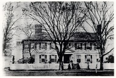 Photo 42 - South Elevation of House circa 1870
Several changes took place during the period which were documented in documents and photographs, as well as in the archaeology. Structure L, the large kitchen, was altered, receiving a facade of board-and-batten siding and a layer of clay fill in the interior and along the western exterior. The clay may have been an attempt to seal moisture from the building. The old wine cellar under the kitchen was sealed with a layer of cement, converting it into a cistern for water collection. The last half of the nineteenth century also saw the erection of a water-pumping windmill over the well.
All buildings in the 28G Area were torn down during the 1860 to 1900 period. The two pecan trees which still remain on the site were planted, and most of the area north of the present access drive was turned into a plowed field early in this period.
176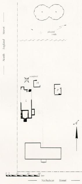 Figure 70 - Periodization Map 8 - 1860-1900
11. 1900-1920 (Fig. 71)
This period defines the approximate Warburton ownership of the Peyton Randolph House, a time just prior to the beginning of residents' recollections. Structure L was finally removed. An early twentieth-century photograph (Photo 46) indicates that Structure L had been removed by the second decade of the twentieth century, though a past resident of the Randolph House does recollect a hand pump over the cistern in the early 1920s. The same photograph also reveals that two seemingly eighteenth-century outbuildings, a smokehouse and a dairy, were still standing in this period. Both were probably removed during these two decades. The windmill was offered for sale in a 1920 Virginia Gazette. It was probably dismantled the same year. Any remaining outbuildings were removed. A kitchen and maid's quarters was added on to the rear of the main house either late in the last period or early in this one. It was not investigated archaeologically.
12. 1920-1938 (Fig. 72)
This period reflects the last individual ownership of the Randolph property. The Wilson/Ball family bought the house early in the 1920s, after having rented the dwelling from real estate brokers Williamsburg, Inc. since 1919. The original lot had by now been divided into several smaller lots. Two residential structures were built on the sub-divided lots in 1924 and 1926. Both buildings had basements, destroying any archaeological evidence of previous structures or features. City water was connected and telephone and electric cables put in. Use of the cellar as a cistern was discontinued and it was then filled with household debris in circa 1926. The Colonial Williamsburg Foundation acquired the Peyton Randolph House from Mrs. Ball in 1938, though she continued to live in the main house until 1947. The first archaeological investigation of the house and yard was conducted by CWF Architecture Department in 1938. After an archaeological survey was made of the foundations of Structure S, it was reconstructed by the Foundation.
13. 1938-1985 (Fig. 73)
Radical changes took place in this forty-seven year period of Foundation ownership. The main house was fully restored in the early 1940s to its physical appearance (according to the Architecture Department) during the Peyton Randolph period (1755-1775). Structure N was reconstructed to serve as a kitchen for the Ball family while the main house was being restored.
Archaeological cross-trenching took place in 1955 in the back lot, and a replica of Robertson's windmill was built in its present location. Colonial Williamsburg had acquired the remainder of the land associated with the Randolph House by the 1960s. Both of the 1920s houses were removed by the early 1970s. The land between the windmill and the main house was undisturbed until full-scale archaeology began is 1977-1978, and was continued in 1982-1985.
178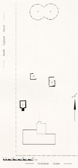 Figure 71 - Periodization Map 9 - 1900-1920
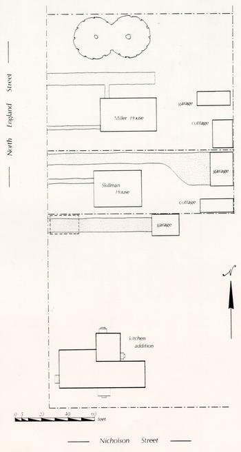 Figure 72 - Periodization Map 10 - 1920-1938
 Figure 73 - Periodization Map 11 - 1938-1985
Having been acquired by an outdoor museum and becoming a public exhibition building rather than a private residence2, the Randolph House has ceased becoming part of any individual's outward manifestation of social standing, self-worth, or idiosyncrasies. But it will no doubt continue to change, both in structure and in the ways it influences people's understanding of the eighteenth century in Williamsburg.
182CHAPTER SEVEN: ARTIFACTS
by William E. Pittman, Supervisor of Collections Research
The following section illustrates several of the artifacts mentioned throughout this report, most notably those associated with Structure A, the planting beds, and other significant features. Principal measurements of the illustrated artifacts are given on page 209; a full catalog is on file with the Department of Archaeological Research Laboratory.
FIGURE 74
A. ENGLISH BEVERAGE BOTTLE
This cylindrical beverage bottle, found in the plaster layer on the interior of Structure A, is composed of a dark green metal which exhibits devitrification over much of its surface. The body surface of the vessel has been eroded to the point where it is impossible to determine if it was formed in a dip mold, although straight-sided bottles of this type generally were formed in this manner. The push-up can be described as dome-shaped, and there is an indistinct pontil scar. The heel of the bottle shows very little bulging; the sides of the vessel are straight-sided. The neck tapers consistently toward the finish and the string rim is down-tooled. The string rim is inconsistently applied just below the lip of the neck. The mouth of the neck has been tooled outward and the rounded edges of the lip suggest that it was fire-polished. Beverage bottles of this style and shape are generally dated to the mid-eighteenth century (Noël Hume 1978:68-68). Catalog number 4004-28G-89J.
185 Figure 74 - English Beverage Bottle
FIGURE 75
A. FULHAM-TYPE ENGLISH BROWN STONEWARE TANKARD
This is the base of a salt-glazed brown stoneware tankard, composed of a pale grayish-brown homogenous clay body which has been partially dipped in brown iron oxide glaze to form the only applied decoration. Three evenly-spaced raised cordons formed by paired incised lines running parallel to the base are located slightly above the rounded heel. The interior of the vessel is evenly covered with a brown glaze beneath the clear salt glaze. It was found in the plaster layer on the interior of Structure A. Catalog number 4006-28G-89N.
B. NOTTINGHAM STONEWARE TANKARD
This salt-glazed stoneware tankard, found in the ashy loam on the interior of Structure A, is of the type that was produced in Nottinghamshire during the entire eighteenth century (Noël Hume 1978:114). The glossy brown surface of the vessel is augmented with a broad band of mechanically incised decoration and a similar band of applied partially crushed grog in a style of decoration what is generally termed rustication. These bands of decoration encircle the straight-sided body. A pinched terminal of an extruded handle survives. The interior of the vessel is evenly covered with a pale brown glaze beneath the clear salt glaze. Catalog number 4005-28G-2175K.
C. WESTERWALD BLUE AND GREY STONEWARE TANKARD
This cylindrical tankard, found in the rubble layer on the interior of Structure A, is composed of a grey stoneware body which has been decorated with incised lines and hand-painted with cobalt blue under a standard salt glaze. The side of the vessel bears an applied sprig-molded medallion consisting of the initials "G R" beneath a crown. The tankard is further decorated with raised cordons encircling the body of the vessel. This type of vessel is commonly found on colonial-period sites throughout the first three quarters of the eighteenth century (Noël Hume 1978:285). Catalog number 4010-28G-84J.
187 Figure 75 - Stoneware Tankards
Figure 76
A. ENGLISH DELFTWARE FIREPLACE TILE FRAGMENT
This is one corner of an English fireplace tile, composed of a rather coarse grayish-buff colored body which has been decorated with a thin layer of lead-based glare which has been opacified by the addition of tin oxide. Only one side of the tile has been glazed or decorated in any manner. The hand painted decoration has been executed entirely in manganese purple and consists of a pair of concentric circles which provided an encompassing border for the central painted design. Noël Hume suggests that tiles displaying this double-lined central motif became common by the end of the seventeenth century and continued in common use for approximately sixty years (Noël Hume 1978:293). The corner motif, which consists of a four-lobed motif, is similar to those illustrated by Noël Hume and Schaap, identified as "bug" or "spider's head" designs (Noël Hume 1978:292; Schaap et al. 1984:177). The tile was found in the fill under the fireplace nosing in Structure A. Catalog number 4001-28G-170.
189 Figure 76 - English Delftware Fireplace Tile
FIGURE 77
A. CHINESE PORCELAIN SAUCER FRAGMENT
This small saucer, found in the plaster layer on the interior of Structure A, is composed of a dull white porcelain paste with a bluish felspathic glass. The hand-painted designs are executed in cobalt blue under-the-glaze and with red and gold over-the-glaze. The rim of the saucer is decorated with alternating cartouches of indistinctly painted floral devices under-the-glaze and red over-the-glaze diaper devices. The designs in the cavetto of the saucer consist of what may be a landscape with vegetation in blue and blossoms and other foliation in red. This sherd is quite thin and is translucent in strong light. Catalog number 3897-28G-89E.
B. CHINESE PORCELAIN CUP FRAGMENT
This handled cup, found in the rubble layer on the interior of Structure A, is composed of a grayish-white porcelain paste covered completely with a clear glaze. The hand-painted decoration is executed in under-the-glaze cobalt blue. The landscape designs include mountains, pagoda-type structures, and willow boughs. The interior of the cup is undecorated. Catalog number 3900-28G-84N.
C. CHINESE PORCELAIN SHALLOW BOWL
This straight-rimmed bowl, found in the plaster layer on the interior of Structure A, is made of a nearly white porcelain paste which is covered with a bluish-white glaze. The hand-painted decoration is done in a dark under-the-glaze cobalt blue with over-the-glaze red and gold. The rim is further ornamented with a lustrous brown glaze. The rim is accented with alternating fields of red with gold overlay and nearly empty fields of red floral sprays. These are confined within two parallel under-the-glaze blue lines. The decoration in the cavetto of the vessel appears to be a random arrangement of under-the-glaze blue foliage with over-the-glaze red blossoms, highlighted with touches of gold. This vessel has no marly, but is further enhanced with reverse painting in blue and gold on the exterior wall. Catalog number 3881-28G-89N.
D. CHINESE PORCELAIN CUP OR TEA BOWL RIM FRAGMENT
This tea bowl or cup, found in the ashy loam on the interior of Structure A, is decorated with under-the-glaze cobalt blue and over-the-glaze red and gold hand painting. The rim is decorated with a lustrous brown glaze above a broad band defined by two parallel blue lines. Within this band are alternating fields of red over-the-glaze diaper motifs and smaller cartouches of blue with additional red over-the-glaze blossoms highlighted with gold. The remainder of the painted decoration consists of a random floral arrangement in blue, red and gold. Catalog number 3909-28G-2170E.
E. CHINESE PORCELAIN PLATE RIM FRAGMENT
This plate rim, found in the ashy loam on the interior of Structure A, is composed of a white porcelain paste with a bluish-grey felspathic glaze. The hand-painted decoration is executed entirely in cobalt blue. The design which survives on the marly is a large peony blossom which was a symbol of spring, love and affection, and good fortune (van der Pijl-Ketel 1982:278). The cavetto appears to be empty and the center or well of the plate most likely exhibited a landscape with pine-like vegetation. Catalog number 3880-28G-2175K.
191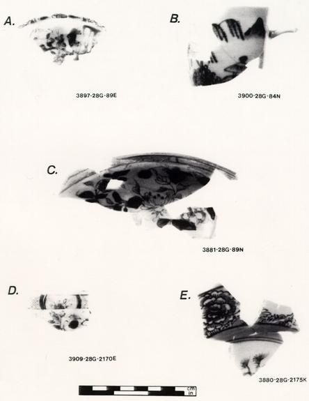 Figure 77 - Chinese Porcelain Vessels
FIGURE 78
A. ENGLISH DELFTWARE BASIN FRAGMENT
This dish or basin, found in the plaster layer on the interior of Structure A, is composed of a soft buff-colored earthenware body which has been covered with a pale bluish-white tin fluxed lead glaze. The hand-painted decoration is accomplished in a dull cobalt blue in the chinoiserie style. The narrow marly or rim is decorated with alternating fields of Chinese diaper motifs and stemmed blossoms defined by double lines below and a single line at the rim. The relatively deep cavetto is unpainted except for a single line just above the flat of the vessel's center. The decoration in the flat of the center has not survived in sufficient quantity to be described in detail. Catalog number 3865-28G-89N.
B. ENGLISH DELFTWARE PUNCH BOWL FRAGMENT
This small bowl, found in the plaster layer on the interior of Structure A, is covered with a grayish-blue lead glaze and is hand-painted with a bright cobalt blue. The sparse decoration consists of non-contiguous sprays of floral elements alternating with larger leaf motifs. There is no painted decoration in the interior of the vessel. Catalog number 3848-28G-89E.
C. ENGLISH DELFTWARE PLATE RIM FRAGMENT
This plate, found in the plaster layer on the interior of Structure A, is composed of a soft buff-colored earthenware body covered with a bluish-white tin-enamelled lead glaze. The rim of the plate has been painted with a reddish-brown glaze in imitation of the edge decoration which appears on Chinese porcelain teawares. The hand-painted decoration consists of a broad band below the rim defined by a single blue line above and a double line below. Within these lines are fields containing boldly painted wavy lines alternating with four dots and sets of opposing hatched lines. The underside of the plate rounded with no reverse painting. Catalog number 3849-28G-89K.
D. ENGLISH DELFTWARE PLATE RIM FRAGMENT
This delftware plate, found in the plaster layer on the interior of Structure A, is evenly covered with a bluish-grey lead glaze and is hand-painted with two tones of cobalt blue. The rim decoration consists of a broad field of pale blue which is overpainted with a scroll in a darker shade of blue. This alternates with an area of white broken only with a tri-lobed blossom appended from the upper edge of the field nearest the rim. Catalog number 3852-28G-89K.
193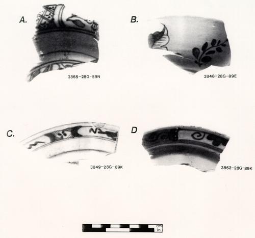 Figure 78 - English Delftware Vessels
FIGURE 79
A. STAFFORDSHIRE RED SANDYWARE MILK PAN RIM
This is the rim of a red earthenware milk or cream pan which is composed of a homogenous brick-red clay with a grey reduced core in the thickest portions of the vessel walls. The clear lead glaze appears as a warm caramel colored, glossy covering of the interior portions of the pan only. The rim is rounded with a narrow concave channel running up to a rounded shoulder. The vessel was found in the ashy loam over the pipe-stem layer on the interior of Structure A. Catalog number 4009-(E.R.) 2173P-28G.
B. COLONO-INDIAN EARTHENWARE BOWL
This earthenware bowl or porringer fragment, found in an artifact concentration in the southwestern corner of Structure A, is composed of a soft tan-colored clay with a small flecks of naturally occurring red ocher and a burnished surface. There is no glaze and the only attempt at decoration is a slightly evened lip. Noël Hume identified this ceramic type as colono-Indian and attributes it as early as 1690 and as late as the end of the eighteenth century (Noël Hume 1962:b). Catalog number 4007-28G-108H.
C. COLONO-INDIAN SHALLOW PAN RIM FRAGMENT
The fabric of this vessel is identical in color, texture, and appearance to that described in vessel B above. This vessel form is an open, shallow pan or bowl with a flattened rim and deep cavetto. This vessel was also found in an artifact concentration in the southwestern corner of Structure A. Catalog number 4008-28G-108H.
195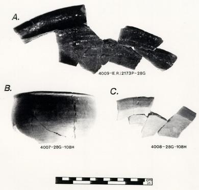 Figure 79 - Staffordshire Red Sandyware and Colono-Indian Ware Vessels
FIGURE 80
A. CHINESE PORCELAIN TEA BOWL BASE FRAGMENT
This base fragment of Oriental porcelain, found in Planting Bed 4, is composed of a nearly white, porcelain paste which has been hand-painted with cobalt blue beneath the clear felspathic glaze and with red and gold over the glaze. The central motif in the well of the small bowl consists of a somewhat indifferently-executed potted plant. The floral components of the design are accomplished with the over-glaze painting and take the form of blossoms in red and gold. The central design is encircled with a single cobalt blue line. Catalog number 2211-28G-2067.
B. CHINESE PORCELAIN SAUCER FRAGMENT
This fragment of a saucer, found in Planting Bed 4, has been entirely decorated with cobalt blue painting under a clear felspathic glaze. The paste of the vessel is a dull grayish-white. The painted decorations consist of a broad band of alternating hatch marks between single lines which is commonly seen on porcelains of the first quarter of the eighteenth century. Below this are panels which alternate around the cavetto of the saucer and contain floral designs and panels which are further sectioned containing small, casually painted blossoms. The central motif was most likely a similar blossom. Reverse painting appears on the exterior wall and rim of the saucer. Catalog number 2209-28G-2066.
C. CHINESE PORCELAIN PLATE RIM FRAGMENT
Thin porcelain plate, found in Pleating Bed S, is composed of a pale grayish-white paste which has been evenly covered with a pale blue felspathic glaze. The hand-painted decoration has been executed entirely in over-the-glaze pastel enamels and red. The enamels have deteriorated leaving a dull grayish-white and pinkish surface. This thickly-applied enamel decoration was most likely similar to that which is known as "famille rose" and was first used in 1685 (Noël Hume 1978:259). Catalog number 2210-28G-1584F.
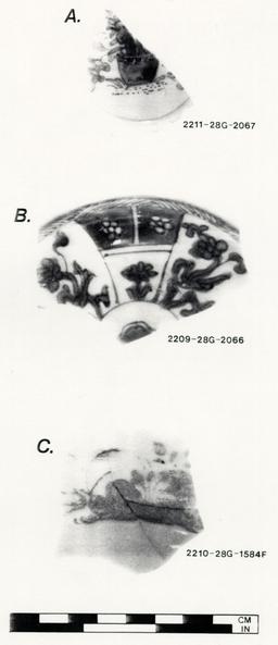 Figure 80 - Chinese Porcelain Vessels
FIGURE 81
ENGLISH GLASS BEVERAGE BOTTLES
This photograph shows the typical vessel forms of glass bottles that were retrieved from two of the planting bed features on the Peyton Randolph site. They are all freeblown vessels which can be characterized as bulbous and mallet-shaped. All of the examples show here have applied string rims which were either left untooled or have been down-tooled. All of the bulbous examples have flattened dome-shaped push-ups and pronounced pontil scars.
199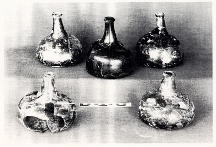 Figure 81 - English Glass Beverage Bottles
FIGURE 82
A. FULHAM-TYPE ENGLISH BROWN STONEWARE TANKARD FRAGMENT
This salt-glazed stoneware tankard, found in Planting Bed 2, is composed of a pale tannish-grey stoneware body which as been sealed with a salt glaze. The heel is rounded and is ornamented with a series of raised cordons near the base. A single excise stamp has been impressed into the clay body near the lower handle terminal. Although the tankard body was fractured through this stamp, the initial "G" can be seen which suggests that this vessel was made at some time following the assumption of the English throne by the House of Hanover in 1714 (Delderfield 1978:104). Catalog number 2251-28G-1075.
201 Figure 82 - Fulham-Type Brown Stoneware Tankard
FIGURE 83
A. ENGLISH DELFTWARE OINTMENT POT
This undecorated ointment or salve pot, found in Planting Bed 2, is composed of a pale buff-colored earthenware body with a thinly applied and crazed pinkish-white lead glaze. The rim of the vessel has been left unglazed and the flaring foot is dome-shaped. Catalog number 2238-28G-1074.
B. ENGLISH DELFTWARE OINTMENT POT
This undecorated ointment pot, found in Planting Bed 2, is very similar in all respects to the pot described above, except in size. The everted rim is unglazed and the tin-enamelled glaze is pinkish-white in color. Catalog number 2245-28G-1075.
C. ENGLISH DELFTWARE CHAMBER POT FRAGMENT
This chamber pot base fragment, found in Planting Bed 3, is composed of a buff-colored earthenware body glazed with a tin-opacified lead glaze. There is no painted decoration but a single scroll handle terminal can be seen just above the base. Catalog number 2225-28G-1533G.
D. ENGLISH DELFTWARE DRUG JAR
Cylindrical drug jars of this type were commonly used to store dry pharmaceutical substances during the seventeenth and eighteenth centuries. This form of drug container is often decorated with simple bands of color applied over the tin-enamelled lead glaze. This example, found in Planting Bed 1, is glazed with a pale bluish-white ground and pale bluish-grey bands running horizontal to the base. The interior of the vessel shows no attempts at further decoration. Catalog number 2218-28G-1089.
E. ENGLISH DELFTWARE DRUG JAR BASE FRAGMENT
This drug jar is very similar to vessel C. The body is a pale buff-colored earthenware and the glaze is a pale bluish-white. The painted horizontal lines are a bluish-grey. The vessel was found in Planting Bed 1. Catalog number 2215-28G-1069.
203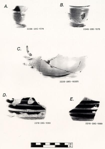 Figure 83 - English Delftware Vessels
FIGURE 84
A. STAFFORDSHIRE RED SANDYWARE DISH FRAGMENT
This is the rim and portion of the marly of a Staffordshire earthenware dish or basin, found in Planting Bed 4. The body is a homogenous brick red, finely grained clay which exhibits a reduced core of pale grayish-brown in the center of the thickest parts. The interior surfaces are covered with a clear lead glaze which appears to be caramel in color due to the color of the body beneath it and the impurities in the glaze itself. The marly is slightly concave as it runs outward toward the rim. The rim flattens but retains its roundness until it disappears into the surface of the unglazed exterior. Catalog number 2261-28G-2068.
B. YORKTOWN-TYPE COARSE EARTHENWARE PAN RIM FRAGMENT
The body of this earthenware cream pan, found in Planting Bed 1, is composed of a pale pink to buff-colored clay with reddish-brown inclusions. The clear lead glaze is glossy and due to the color of the body underneath it, appears to be a warm caramel color. Additionally, there are numerous blackish-brown marks burned through the glaze caused by iron-rich impurities in the clay body. The rim projects inward from the vessel's interior surface and rolls outward to form a rounded rim on the exterior. Only the interior of the vessel is glazed. Catalog number 2257-28G-1069.
C. STAFFORDSHIRE RED SANDYWARE CREAM PAN RIM FRAGMENT
This fragment, found in Planting Bed 4, is composed of a reddish homogenous clay body with a reduced core in the center of the thickest part of the rim. The interior surfaces are covered with a glossy clear lead glaze which appears to be a light caramel-color. A large pebble-like inclusion can be seen protruding through the glaze on the surface of the fragment. The rim of the vessel has a narrow channel or concavity separating the two pronounced edges of the interior vessel wall and the rim. The corner of a pouring channel or spout can be seen in the photograph on the left of the fragment. This feature was formed by distorting the rim while the clay was still in a malleable state. Catalog number 2264-28G-2066.
205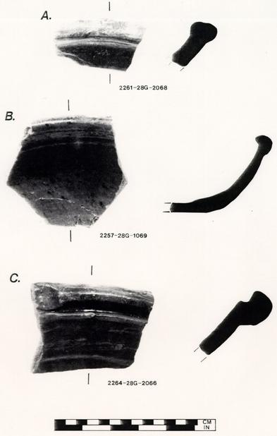 Figure 84 - Coarseware Vessels
FIGURE 85
A. GLASS BOTTLE SEAL
This circular glass bottle seal, discovered in the interior of Structure H, is from an English beverage bottle and is consistently covered with a golden brown surface devitrification. The seal has been impressed with the name "Thos. Hornsby" above the date "1769." Seals of this type were generally applied to the sides or shoulders of custom-made bottles in the seventeenth and eighteenth centuries. Though the dates on such seals are useful in assigning ownership, they are not always good indications of the date of manufacture (Jones 1986:15, 3l). Catalog number 4000-28H-608.
207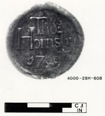 Figure 85 - Glass Bottle Seal
 AERIAL PHOTOGRAPH
PRINCIPAL MEASUREMENTS OF ILLUSTRATED ARTIFACTS
FIGURE 1 (Catalog number 4004-28G-89J)
Height of vessel: 8 1/8" (20.8 cm)
Diameter of base: 4 ¾" (12.06 cm)
Diameter of shoulder: 4 ¾" (12.08 cm)
Height of push-up: 1 25/32" (4.5 cm)
Diameter of pontil scar: 2 ¾" (8.9 cm)
Diameter of bore: 5/8" (1.b8 cm)
FIGURE 2A (Catalog number 4006-28G-89N)
Approx. diameter of base: 5 ¾" (14.6cm)
FIGURE 2B (Catalog number 4005-28G-2175K)
Diameter of base: 4 ¾" (12.06cm)
FIGURE 2C (Catalog number 4005-28G-84J)
Diameter of base: 4 ½" (11.43cm)
Maximum height of vessel: 5 15/16" (15.08cm)
FIGURE 3 (Catalog number 4001-28G-170)
Thickness of tile: 6/32" (0.47cm)
FIGURE 4A (Catalog number 3897-28G-89E)
Diameter of saucer: Approx. 4 ½" (11.4cm)
Height of saucer: Approx. ¾" (1.9cm)
Diameter of standing ring: Approx. 2 ¼" (5.7cm)
FIGURE 4B (Catalog number 3900-28G-84N)
Estimated height of cup: Approx. 2 ½" (6.3cm)
Diameter of cup rim: 2 17/32" (6.43cm)
FIGURE 4C (Catalog number 2881-28G-89N)
Diameter of vessel: Approx. 9" (22.8cm)
Height of vessel: 1 9/16" (3.97cm)
FIGURE 4D (Catalog number 3909-28G-2170E)
Diameter of vessel: 2 ¾" (6.9cm)
FIGURE 4E (Catalog number 3880-28G-2175K)
Estimated diameter of plate: Approx. 9" (22.0cm)
FIGURE 5A (Catalog number 3865-28G-89N)
Estimated diameter of vessel: Approx. 10" (25.4 cm)
FIGURE 5B (Catalog number 3848-28G-89E)
Diameter of vessel: 5" (12.7cm)
FIGURE 5C (Catalog number 3849-28G-89K)
Diameter of plate: Approx. 9" (22.9cm)
FIGURE 5D (Catalog number 3852-28G-89K)
Diameter of plate: Approx. 9" (22.9cm)
FIGURE 6A (Catalog number 4009-E.R.2173P-28G)
Diameter of rim: Approx. 15 ½" (39.2cm)
FIGURE 6B (Catalog number 4007-28G-108H)
Diameter of rim: 4 ½" (11.4) cm
FIGURE 6C (Catalog number 4008-28G-108H)
Diameter of vessel: Approx. 10" (25.4cm)
FIGURE 7A (Catalog number 2211-28G-2067)
Diameter of standing ring: 1 17/32"
FIGURE 7B (Catalog number 2209-28G-2066)
Diameter of vessel: 4 ½" (11.4cm)
Diameter of standing ring: 2 ¼" (5.7cm)
Height of vessel: 7/8" (2.2cm)
FIGURE 7C (Catalog number 2210-28G-1548F)
Estimated diameter of plate: 9" (22.8cm)
FIGURE 9 (Catalog number 2251-28G-1075)
Estimated diameter of base: 4 ¼" (10.7cm)
FIGURE 10A (Catalog number 2238-28G-1074)
Diameter of rim: 1 7/8" (4.7cm)
Height of vessel: 1 11/16" (4.2cm)
FIGURE 10B (Catalog number 2245-28G-1075)
Diameter of rim: 2 ½" (6.3cm)
Height of vessel: 1 15/16" (4.9cm)
FIGURE 10C (Catalog number 2218-28G-1069)
Diameter of base: Approx. 7 ½" (19.0cm)
FIGURE 10D (Catalog number 2225-28G-1533G)
Maximum diameter of base: Approx. 8" (20.3cm)
FIGURE 10E (Catalog number 2215-28G-1069)
Estimated diameter of base: Approx. 7" (17.7cm)
FIGURE 11A (Catalog number 2261-28G-2068)
Estimated diameter of vessel: 13 ½" (34.3 cm)
FIGURE 11B (Catalog number 2257-28G-1069)
Diameter of rim: Approx. 13" (33.0cm)
Height of vessel: 2 5/8" (6.66cm)
FIGURE 11C (Catalog number 2264-28G-2066)
Estimated diameter of vessel: 15 ½"
FIGURE 12 (Catalog number 4003-28H-748)
Maximum diameter of seal: 1 3/8" (3.49cm)
REFERENCES CITED
- 1983
- Final Report: The Years of Construction of the Geddy House and the Peyton Randolph House (Phase I and II) as Derived by the Key-Year Dendrochronology Technique. Report submitted to the Department of Architectural Research, Colonial Williamsburg Foundation, Williamsburg.
- 1956
- Statistical Analysis of Artifacts—Windmill Area. Ms. on file, Department of Archaeological Research, Colonial Williamsburg Foundation, Williamsburg.
- 1982
- Techniques of Archaeological Excavation. Second edition. Universe Books, New York.
- 1969
- Metres, Areas, and Robbing. World Archaeology 1(2):208-219.
- 1969
- Geology of the Williamsburg, Hog Island and Bacon's Castle Quanrangles, Virginia. Virginia Division of Natural Resources, Report of Investigations No. 18. Charlottesville.
- 1970
- Archaeology at Hatchery West. Society of American Archaeology Memoirs 24.
- 1981
- Behavioral Archaeology and the "Pompeii Premise." Journal of Anthropological Research 37(3):195-208.
- Brown, Marley R., III, and Patricia M. Samford - In press
Recent Evidence of Gardening in Eighteenth-Century Williamsburg. In Landscape Archaeology: Proceedings of the Monticello-University of Virginia Conference on Landscape Archaeology, Charlottesville, Virginia, 1986, edited by William M. Kelso. University Press of Virginia, Charlottesville. - 1981
- Williamsburg Architecture as Social Space. Fresh Advices: A Research Supplement. Copy on file, Department of Architectural Research, Colonial Williamsburg Foundation, Williamsburg. 212
- 1972
- The Randolphs of Virginia. Doubleday, Garden City, New York.
- 1977
- In Small Things Forgotten. Anchor Books, Garden City, New York.
- 1978
- Kings and Queens of England. Weathervane Books, New York.
- 1987
- Excavation at Colonial Williamsburg Thirty Years Ago: An Archeological Analysis of Cross-Trenching Behind the Peyton Randolph Site. American Archaeology 6(1):10-19.
- 1939
- Archaeological Report (Peyton Randolph). Ms. on file, Architecture Department, Colonial Williamsburg Foundation, Williamsburg.
- 1985
- Building an Image: An Architectural Report on the Peyton Randolph Site. Ms. on file, Department of Architectural Research, Colonial Williamsburg Foundation, Williamsburg.
- 1954
- Dating Stem Fragments of Seventeenth and Eighteenth Century Clay Tobacco Pipes. Quarterly Bulletin of the Archaeological Society of Virginia 9(1):9-13.
- 1979
- Principles of Archaeological Stratigraphy. Academic Press, New York.
- 1975
- Field Methods in Archaeology. Mayfield Publishing Co., Palo Alto, California.
- 1986
- The Parks Canada Glass Glossary. Parks Canada, Ottawa.
- 1978
- Peyton Randolph House, 1978: Interim. Notes. Ms. on file, Department of Archaeological Research, Colonial Williamsburg Foundation, Williamsburg.
- 1952
Architectural Report (Including Archaeological Report), Peyton Randolph House, Block 28, Building 6. Ms on file, Department of Architectural Research, Colonial Williamsburg Foundation, Williamsburg.- 1975
- The Jamestown Frontier: An Archaeological Study of Colonization. Ph.D. dissertation, Department of Anthropology, University of Oklahoma. University Microfilms, Ann Arbor. 213
- 1982
- The Variability of Faunal Samples and their Effects on Ageing Data. In Ageing and Sexing Animal Bones from Archaeological Sites, edited by Bob Wilson, Caroline Grigson, and Sebastian Payne, pp. 81-90. B.A.R. British Series 109. B.A.R., Oxford, England.
- 1982
- Sheet Refuse: An Indicator of Past Lifeways. In Settlement of the Prairie Margin, edited by L. Mark Rabb, pp. 139-152. Archaeology Research Program, Southern Methodist University, Dallas.
- 1963
- Clay Tobacco Pipe Dating in Light of Recent Excavations. Quarterly Bulletin of the Archaeological Society of Virginia 18(12):22-25.
- 1962
- An Indian Ware of the Colonial Period. Quarterly Bulletin of the Archaeological Society of Virginia 17(1):1-68.
- 1969
- a
A Guide to Artifacts of Colonial America. Alfred A. Knopf, New York. - 1969
- b
Pottery and Porcelain in Colonial Williamsburg's Archaeology Collections. Colonial Williamsburg Archaeological Series No. 2. The Colonial Williamsburg Foundation, Williamsburg. - 1970
- The Rise and Fall of English White Salt Glazed Stoneware. Antiques XCII(2):248-255, XCII(3):408-413.
- 1972
- Historical Archaeology. Alfred A. Knopf, New York.
- 1978
- A Guide to Artifacts of Colonial America. Second edition. Alfred A. Knopf, New York.
- 1975
- Clay Pipes for the Archaeologist. British Archaeological Reports 14. B.A.R., Oxford, England.
- Ralph, E., and M.C. Han - 1966
Dating of Pottery by Thermoluminescence. Nature 210:24-247. - 1961
- Tea Drinking in 18th Century America: Its Etiquette and Equipage. Contributions from the Museum of History and Technology, United States National Museum Bulletin 225:61-91. Smithsonian Institution, Washington, DC.
- 1984
- Dutch Tiles in the Philadelphia Museum of Art. University of Pennsylvania Press, Philadelphia. 214
- 1980
- The Domestic Environment in Early Modern England and America. Journal of Social History 14(1):3-24.
- 1952
- Peyton Randolph House. Revised by Jane Carson, 1967. Ms. on file, Foundation Library, Colonial Williamsburg Foundation, Williamsburg.
- 1974
- Fort Michilimackinac, 1715-1781: An Archaeological Perspective on the Revolutionary Frontier. Michigan State University Museum, East Lansing.
- 1968
Problems, Method, and Organization: A Disparity in the Growth of Archaeology. In Anthropological Archaeology in the Americas, edited by Betty Meggers, pp. 131-151. Anthropological Society of Washington, Washington, DC.- 1957
- Brothers of the Spade: Correspondance of Peter Collinson of London and John Custis of Williamsburg, Va. 1734-1746. Barre Gazette, Barre, Massachusetts.
- 1982
- The Ceramic Load of the 'White Leeuw.'" Rijksmuseum, Asterdam.
- 1783
- Nicolson and Prentis, publishers, Richmond, February 15, 1783. Microfilm on file, Foundation Library, Colonial Williamsburg Foundation, Williamsburg. Accession No. M-1024-1.
- 1970
- Some Thermoluminescent Dates for Linear Pottery. Antiquity LXIV:304-305.
Footnotes
APPENDIX 1
PEYTON RANDOLPH'S INVENTORY
| 12 Mahogany Chairs £15 2 Mahogany table £8 | £ 23: : |
| 1 Card Table £2 1 Marble Table £2 | 4: : |
| 1 Side Board Table 20/ 1 Carpet 20/ | 2: : |
| 4 looking Glasses £20 1 pr. Endirons £2 | 22: : |
| 5 China Bowls £5 5 China Mugs 15/ | 5:15: |
| 8 Dozn. red and White China plates £6 22 Do. dishes £5 | 11: : |
| 1 Blue and White China Tureen 20/ 11 Blue & White dishes £4 | 5: : |
| 4 Blue & White China Sauce boats 10/ 2 Do. potting pots 15/ | 1: 5: |
| 21 Custard Cups & Patty Pans 10/ 6 Scollop Shells 15/ | 1: 5: |
| 12 Egg Cups 6/ 13 Blue and White Coffee Cups & Saucers 10/ | :16: |
| 18 Blue and White China Plates 22/ 5 Beer Glasses 5/ | 1: 7: |
| 4 fruit Baskets 20/ 1 Queen China mug & Sugar dish | 1: 2: |
| 1 Marble Bowl 15/ 15 Water Glasses 30/ | 2: 5: |
| 10 Wine Glasses 12/ 5 punch do. 5/ | :17: |
| 1 Mahogany Tray 10/ 9 Decanters and 4 Baskets 25/ | 1:15: |
| 1 ... Do ... Case containing 2 Bottles 25/ | 1: 5: |
| 1 round Mahogany table 26/ 1 plate warmer 12/ | 1:18: |
| 492 Oz. Plate @ 7/6 | 84:10: |
| 1 Plate Basket and 2 knive Do. 10/ 3 ½ doz. knives & forks £5 | 5:10: |
| 1 Mahogany tea Board 7/6 Japand Waiters 10/ | :17: |
| 1 Chariot and 8 Harness | 60: : |
| 5 Chariot Horses £230 ... 3 Cart Do. £25 | 255: : |
| 1 Mare and Colt £40 1 riding Horse £30 | 70: : |
| 1 Phaton £15. 5 Cows £20 | 35: : |
| 2 Carts and 1 Tumbrill and Harness | 20: : |
| 11 Frying pans at 3/ | 1:13: |
| 25 Bushels Salt at 3/ | 3:15: |
| A parcel Wool 40/ A percel Hemp and Flax 10/ | 2:10: |
| A parcel Lumber in the Store house 20/ | 1: : |
| 5 Bushels Malt 15/ | :15: |
| 4 old Scythtes 10/ 1 Bedstead 15/ a Cross Cut Saw 15/ | 2: : |
| 10 old Jacks 5. A parcel of tallow 25/ a pr. Stilliards 12/6 | 2: 2: 6 |
| a parcel corks 50/ a pipe of Sower Cyder 40/ | 4:10: |
| 48 Table Cloths £46:15:36 Towells £2:11: | 49: 6: |
| 9 Napkins 18/ 11 pr. Sheets £16/10 2 pr. Virginia Do. £2 | 19: 8: |
| 6 pr. pillow Cases 15/ 2 Side Board Cloths 5/ | 1: : |
| A parcel Queens China Ware & Sundry Articles Sent to Wilton | 5: : |
| A Sett of Ornamental China | 20: : |
| 1 doz. Mahogany Chairs | 24: : |
| 2 fire Screens £5 1 Card table £2 | 7: : |
| 1 Wilton Caret £10 1 Tea table 20/ 1 Do. 30/ | 12:10: |
| 1 Sett China & Tea Board £3 1 Ditto & Do. 40/ | 5: : |
| 1 Looking Glass £10 1 pr. Tongs, poker Shovel & Fender 20/ | 11: : |
| 1 Black Walnut Press £3 | 3: : |
| 5 Flax Wheels 2 Check Reels & 2 Common Reels | 5: : |
| A dressing table and Glass £5 a Desk & Book case £7 | 12: : |
| 6 old Chairs £3 1 Easy Chair 20/ | 4: : |
| A Small Cabinet & a parcel old China | 2: : |
| A Fender & pr. Tongs 3/ | : 3: |
| 1 Sett old Blue damask Curtains 30/ 2 pr. Window Do. 30/ | 3: : |
| Sundry Articles in Mrs. Randolph's Closet | 3: : |
| 1 Warming pan & pr. Scales & Weights 10/ 2 Spinning Wheels 15/ | 1: 5: |
| 1 Coal Skuttle 5/ 8 Pewter dishes 40/ | 2: 5: |
| 2 doz: pewter plates £3. A parcel old pewter 20/ | 4: : |
| 3 Copper Kettles £15 8 Copper Stewpans £5 | 20: : |
| 1 Safe 30/ 5 pales 10/ 2 fish Kettles and Covers £3 | 5: : |
| 1 Bell Metal Skillet 15/ 1 Marble Mortar 20/ | 1:15: |
| 1 small Marble Mortar 5/ 1 Brass Mortar 5/ | :10: |
| 1 Grid Iron 2 drypping pans & 2 frying pans 25/ | 1: 5: |
| 3 Iron Pots 40/ 1 Tea Kettle 15/ 1 Do. 15/ | 3:10: |
| 1 Jack, 2 Spitts and a pr. Kitchen Dogs | 5: : |
| 8 Stone Butter Pots, 7 Milk pans and 1 Stone Jug 30/ | 1:10: |
| 1 Iron ladle, 1 chopping knive and flesh fork | : 5: |
| 23 Candle moulds 23/ a parcel Old Copper and tin Ware 20/ | 2: 3: |
| 11 Chamber Pots 3 Wash Basons, 35 Wine and 8 Beer Glasses | 2:10: |
| 2 dish Covers, 3 tin Kettles, 8 Sauce pans, 5 Cake Moulds & a Cullender | 1:10: |
| A parcel Brooms and Brushes 20/ 4 Spades 20/ | 2: : |
| 29 Hoes, 1 Chopping knife 6 Scythes & Stones & 3 Cuttg Knives | 5: : |
| 100 lb Brown Sugar 45/ 150 lb Coffee at 1/3 £9/7/6 | 11:12: 6 |
| part of a Box Glass 20/ | 1: : |
| 35 yds Green Cloth at 10/ £12:10: 40 yds Cotton £5 | 17:10: |
| 7 dutch blankets £3/10 10yds Crimson Cloth £7/10 | 11: : |
| About 30 yds Green planes at 2/9 £4/2/6. 20 Ells Oznbr. 25/ | 5: 7: 6 |
| 7 Sifters 9/ 4 pr. Coarse Shoes 24/ 3 Jack lines 9/ | 2: 2: |
| 6 Flat Irons & a pr. Broken Dogs 12/ 1 pine Table 3/ | :15: |
| A parcel Wine in Bottles containing almost a pipe | 60: : |
| 4 Jugs 8/ 1 butter pot 2/ A Box & ½ Candles 60/ | 3:10: |
| A firkin Butter 40/ 5 flasks Oil 10/ | 2:10: |
| 30 Gallons Rum £7:10: A parcel Lumber 5/ | 7:15: |
| 2 Soap Jars 15/ | :15: |
| 6 Mahogany Book Presses at 30/ | 9: : |
| 1 Do. Writing Table £3 1 large Mahogany table £5 | 8: : |
| 1 Round table 15/ 1 Paper Press 10/ | 1: 5: |
| 1 Chaffing dish 5/ 1 dry rubbing Brush 3/ | : 8: |
| 1 Clock £5 1 pr. Back Gammon tables 10/ | 5:10: |
| 1 old pine table 3/. 6 Mahogany Chairs 40/ | 2: 3: |
| 1 Lanthorn | :10: |
| 1 Dressing Table Glass and Toilet | 2:10: |
| 6 Mahogany Chairs £6 1 Bed Table £1/10 | 7:10: |
| 1 China Bason and Bottle 20/ | 1: : |
| 1 Bedstead and Suit Cotton Curtains | 15: : |
| 1 Do. and Do. Virginia Cloth Do. | 10: : |
| 4 pr. Window Curtains 40/ 1 old Carpet 10/ | 2:10: |
| 1 Sett Callico Curtains 50/ 5 Quilts £5 | 7:10: |
| 1 Chintz Bed Cover £3 | 3: : |
| 8 Feather Beds, 7 Bolsters & 9 Pillows | 40: : |
| 4 hair Mattrasses £6 10 Counterpanes £12 | 18: : |
| 3 wool Do. £3 6 pr. new Blankets £9 7 old Do. £4 | 16: : |
| 51 yards Irish Linnen @ 5/ £12/15 24 yards @ Do. £6/5 | 19: : |
| 1 ps. fustian dimity 25/ 100 lb Wt. Sugar £7/10 | 8:15: |
| A parcel Sylabub & Jelly Glasses, 4 Salvers 8 Water Glasses 22 Wine Do. and 3 Glass Candlesticks | 3: : |
| 1 Corner Cupboard & a parcel Physick | 5: : |
| 1 Japann'd Tea Board 5/ 3 Globe Candle Sticks 30/ | 1:15: |
| 1 Screen 30/ a Trussel and 4 old Trunks 20/ | 2:10: |
| 4 Mahogany Chairs £4 1 dressing Glass 30/ | 5:10: |
| 1 Carpet 5/ 1 old Fender Shovel and Tongs 3/ | : 8: |
| 1 Bedstead & Suit Virginia Curtains and Window Curtains | 10: : |
| A mahogany press £3 | 3: : |
| 1 pine Table and Looking Glass 15/ 3 old Chairs 15/ | 1:10: |
| 2 Bedsteads 15/ 1 Fender 5/ 3 Chairs 15/ | 1:15: |
| 1 Bedstead 10/ 1 old Chest drawers 15/ | 1: 5: |
| 1 Pine Table 5/. 1 Floor Cloth 20/ 1 passage Do. 8/ | 1:13: |
| 5 Hoes, 1 Dung fork, 1 Garden Rake and Spade | :15: |
| 1 Wheel Barrow 8/ 1 pr. Money Scales 10/ | :18: |
| 8 Doz: Bottles at 30/ Gro: | 1: : |
| About 100 Bushels dust Coal | 2:10: |
| A parcel old Casks and Tubs | :10: |
| 1 Steel Mill | 3: : |
| A Liberty of Books as per Catalogue | 250: : |
| £1578:14:6 | |
| Johnny | £100: : |
| Jack | 25: : |
| Billy | 100: : |
| Walt | 100: : |
| Braches | 10: : |
| Ben | 80: : |
| Cesar | 25: : |
| George | 30: : |
| Henry | 30: : |
| Sam | 40: : |
| William | 30: : |
| Bob | 25: : |
| Cesar | 30: : |
| Walt | 25: : |
| Eve | 100: : |
| Charlotte | 80: : |
| Aggy | 60: : |
| Succordia | 10: : |
| Little Aggy | 60: : |
| Kitty | 20: : |
| Betsey | 10: : |
| Lucy | 60: : |
| Katy | 20: : |
| Peter | 15: : |
| Betty | 100: : |
| Roger | 60: : |
| Moses | 60: : |
| £2883:14:6 | |
In Obedience to an Order of York Court dated the 20th of November 1775 We the Subscribers being first Sworn before a Magistrate of Said City have Appraised the Estate of Peyton Randolph Esq: as Wittness
J. Dixon
Wm. Pierce
Alex Craig
Returned into York County Court the 15th day of July 1776 and Ordered to be Recorded
Thomas Everard, CI. Cur.
APPENDIX 2
HUMPHREY HARWOOD LEDGER
Humphrey Harwood Ledger B, p. 19.
| Mrs. Betty Randolph | Dr. | |
| 1777 | ||
| August 23rd | To Mortar and pinting Shead 3/. | £ -. 3.- |
| 1778 | ||
| June 3 | To 125 Bricks 7/. 5 bushs. of lime 7/6. 500 nails 15/. 100 larths 2/6 | 1.12.- |
| To Mendng larthing & plastering in Kitching & Covered way 15/. & hair 9d. | -.15.6 | |
| To Building Steeps to back door 6/ & 2 days labr. 8/. | -.14.- | |
| To White washing Kitching, Closset Covered way [34] | 1.14.- | |
| October 2 | To 73 brick 4/6. 2 bushs. of Mortar 3/. Rubg. & laying A harth 10/. | -.17.6 |
| To Mending Celler wall 2/6. & 1 Days of labour 6/ | -. 8.6 | |
| Decr. 2 | To Repairing marble Chimney Piece 12/, & plaster of Parris 3/ | -.15.- |
| To Mortar [?] & ½ days labour 4/ | -. 4.- | |
| 1781 | ||
| Novemr. 7 | To lime 9d. & Working in A Celler Doorframe 3/. | -. 3.9 |
| [£ 7.7.3] | ||
| Specie | £ 3.10.6 |
| PER CONTRA | Cr. | |
| 1784 | ||
| July 25 | By Cash in full from Benn. Harrison Esqr. through the hands of Mr. Thomas Dawson | £ 3.10.6 |
| Mr. Joseph Hornsby | Dr. | |
| 1784 | ||
| Novr. 4th | To Cash (from Ledger A, Folio 141) | £ 15.17.6 |
| To Bashs. of lime at 1/. | -.14.- | |
| To cuting out & putg. in 5 window frames at 3/ | -.15.- | |
| 5 | To Bushs. of lime 4/ & hair 1/ & 8 days labr. of boys at 1/3. | -.15.- |
| To repairing larthing & plastering to Dary 15/ | -.15.- | |
| Decr. 13 | To 22 ½ bushs. of lime at 1/ & 100 bricks 3/ | 1. 5.6 |
| To 1 bushell of hair 2/ & laying an harth 1/6 | -. 3.6 | |
| To setting up a Grate 7/6. | -. 7.6 | |
| To larthing & plastering 41 yds. at 6d. | 1.10.6 | |
| 1785 | To 3 days labr. at 2/6 & working cellar door at 3/ | -.10.6 |
| August 8 | To 19 bushels of lime 19/ & 1334 bricks at 3/ pr. Centum | 2.19.- |
| To 2 Days labour 5/ & underpining Granary 24/ | 1. 9.- | |
| 19 | To 22 bushels of lime at 1/ | 1. 2.- |
| To 668 bricks at 3/ & 2 days labr. at 2/6 & repairg. Well 15/ | 2. -.- | |
| £ 30.17.11 |
| PER CONTRA | Cr. | |
| 1785 | ||
| August 8th | By 80 Bricks | £ -. 2. |
| 1786 | ||
| February 11th | By His Account to This day | 28. 3.10¾ |
| By Cash to Balance | 2.12. ¼ | |
| £ 30.17.11 |
APPENDIX 3
ARCHAEOLOGICAL REPORT
SEPTEMBER 1939
ARCHAEOLOGICAL REPORT (PEYTON RANDOLPH)
Compiled by Francis Duke, September 1, 1939
Excavation
Trenches were dug down to hardpan over the area north and east of the present house. Ground between the trenches was probed.
Foundations discovered constitute three areas: the old east wing and two groups of outbuildings which are divided by a marl walk running north from the main house.
OUTBUILDINGS WEST OF WALK
First Kitchen
Of three successive kitchens which have left traces along the west property line, north of the house, the earliest was a rectangular wooden structure 19 x 32 feet in plan, with a large chimney1 at north end, built flush against the inside wall. Fireplace was off center to west, but flues may have been sloped to bring chimney out of roof at center.2
It is impossible to discover whether this kitchen had another chimney at the south end, since chimney construction of later date in this area has destroyed any possible evidence.
The 9-inch foundations indicate that the structure was wooden. Parts remain of all four outside walls. Interior foundations were also found, outlining divisions into three cells along the west side and a corridore along the west. These foundations were of unknown purpose. It seems unlikely that they could represent interior partition walls contemporary with the chimney.3
| Brick | 9 ½ x 4 ½ x 2 ½. | English bond. |
|---|---|---|
| Mortar | Shell. | |
| Condition | Fragmentary. |
Second Kitchen
The foundation of a second chimney4 lies just north of the first. This chimney belonged to a second kitchen, of which only part of the east wall and perhaps part of the north5 was found. The east wall, 13 inches thick, is laid on a 21-inch spread footing.6
To the southeast are foundations of three walls and a chimney, which seem to represent a later addition to the same building.7 A corner was found where a newer wall, at the bottom, overlaps the footing of the older, and higher up makes a flush instead of a bonded joint.
The added room forms the leg of an L. Its walls measure 13 inches (on the south and east) and 17 inches (on the north). The difference is not explained.
The chimney is inside, and bonds with the walls.
| Brick | Size varies. | Bats numerous. |
|---|---|---|
| Mortar | Shell. | |
| Condition | Generally bad. |
Third Kitchen
A third set of foundation walls is built partly on the first. The plan is rectangular. The 13-inch brickwork necessarily projects from the 9" wall of the first foundation, but the inside faces of the two line up on the west side, and line up within two inches on the east.8 To the north this third foundation is not traceable beyond the middle of the first kitchen.9 Across the south wall of the first kitchen, laid against it on the outside, was found a cross wall, formed by a double chimney (belonging to the third kitchen) with wing walls flanking its south face.10 The south fireplace opening of this chimney was thus flush with the wing walls, while to the north the chimney projected into the room the whole depth of both fireplaces. The south fireplace opened into a room the floor of which was raised above a brick vault. Thirteen-inch walls to the west, south, and east are well preserved up to a few inches above present grade. Below the vault (the axis of which runs north and south) was a low chamber11 believed to have been used as a wine cellar.12
Access to the wine cellar was provided by a stairway of brick, with wooden nosings, which started up at the wall line on the south, and which was probably protected by a cellar door. This stair is centered on the vault and the common center is 2 feet west of the center of the building.
The vault, 9 inches thick, springs from dwarf walls at a level about 18 inches above the original floor. It appears to be built about three centers, on radii of 6 feet and 2 feet more or less. Buttresses number three on each side, two of them engaged with the foundations to north and south and one at center.
Against the east wall of the wine cellar butts a foundation of 5-foot projection and 12 feet in length, which probably supported steps, a platform, or both, giving access to the third kitchen.
| Brick | 8-8 ½ x 3 ½-4 ½ x 2-2 ½. | English bond. |
|---|---|---|
| Mortar | Shell. | |
| Condition | Vault construction, south chimney foundations and some walls may be fit for reuse with considerable patching. |
Probable Floor Levels
The brick underfires of the first and second kitchens13 were at the level of the original grade, or slightly below it. Both were laid on ashes, which may mean the original was of earth at a lower level. No traces of floor paving were found, and it may be that both kitchens had floors of packed earth.
The third kitchen had a higher floor level over the wine cellar in order to clear the vault, which rose more than a foot higher than grade. This floor may have, been of brick, supported by the vault. The floor of the remainder of the building was probably held to the same level14 but was no doubt of ordinary wood construction.
No traces of hearths were found in front of any of the kitchen fireplaces.15 In the first and second kitchens the earth floor of loose stones may have served. In the third kitchen, where the floors were raised, the hearths were no doubt destroyed with the floors.
Smokehouse
Northeast of the kitchen was found part of the 9-inch brick foundation of a building just over 12 feet wide and of indeterminate length. Only the southern portion of this building could be uncovered, the remainder lying across the present property line.
A pathway, surfaced with marl, was traced along the east side of the kitchen16 and almost as far north as this outbuilding.
The use of this building cannot be deduced from the available evidence. But its proximity to the kitchen suggests that it may have been a smokehouse, wood-house, or other outbuilding.
The brickwork resembles that of the second kitchen, with which it is probably contemporary.
| Brick | 8 ½ x 4 ½ x 2 ½. | English bond. |
| Mortar | Shell. | |
| Condition | Fair. |
Forge
At the northwest corner of the north chimney of the second kitchen is a foundation which seems to represent a fire chamber of great depth.17 Inside was found a layer of ashes 12 inches deep. The foundation might have served for a forge, but evidence is too scanty, to allow of definite conclusions. No traces of walls were found.
This foundation is too close to those of the kitchen chimneys to allow convenient circulation between them. It therefore seems doubtful whether the structure here indicated was in existence at the same time as the first or second kitchen. it may have stood during the period of the third kitchen.
| Brick | Varies. | English bond. |
|---|---|---|
| Mortar | Shell. | |
| Condition | Fragmentary |
Chimney at South
Just south of the basement steps of the third kitchen is a foundation which has the size and shape of a kitchen chimney.18 Some ashes were found here but no traces of underfire paving. A short length of 4-inch brick foundation on the west is of unknown purpose.
A patch of brick paving near the basement stair may have been part of the floor in front of this chimney.
This chimney probably belonged to an outbuilding of the period of the first or second kitchen. The third kitchen extends too far south to have been contemporary.
| Brick | 8 ½ x 4 to 4 ½ x 2 ½. | English bond. |
|---|---|---|
| Mortar | Shell. | |
| Condition | Poor. |
Covered Way
A covered passage is known to have existed between the main house and the kitchen.19 Traces of its foundation remain, bearing considerably east of south and west of north.
Since the floor of the third kitchen20 was near the level of the first floor of the main house, it may be assumed that the connecting passage had a level of not more than one step down from the lower of the two (which was the kitchen), and very likely had the same level.
The comparatively light cross traffic might be provided for by steps, anywhere in the length of this passage.
On the east side are the irregularly spaced foundations of three piers 17 inches square and a longer foundation near the center. The latter may have determined the location of the one or two steps which were probably required to reach grade.21
One or two steps probably existed on the west side but there is no definite evidence to establish their location.22
The slight remains of foundations on the west consists of 9-inch brickwork, which suggests that the wall above was continuous, rather than of the post construction which the piers on the opposite side seem to indicate. It is possible that the passageway had a screen wall, pierced by windows and a door, on the west (the side exposed both to public view and the prevailing winter wind), and free-standing posts or columns on the east.
The Covered Way may have been built later than the kitchen, for its construction must have thrown into disuse the stoop east of the wine cellar.23
| Brick | 8 ½ x 4 ½ x 2 ½. |
|---|---|
| Mortar | Shell. |
| Condition | Unfit for reuse. |
Service Entrances to House24
Three sets of foundations at the south end of the Covered Way represent service entrances of different periods.
1. The earliest of these consists of brick steps (formally with wood nosings) down from grade, and the remains of a basement area-way against the house. These foundations undoubtedly antedate the Covered Way, since one of the piers of the latter was built against the center of the steps.
These steps started at grade and were undoubtedly reached by a marl surfaced pathway25 of which traces were found east of the kitchen.
The east edge of the path was clearly marked and lined exactly with the east edge of the steps.
These steps are considerably farther away from the house wall than are those of the usual basement bulkhead entrance.
This may indicated that they centered under the floor of a porch at first floor level. Such a porch could have been reached by steps from the side. But there is no evidence of such steps. The first floor house wall has not been investigated for evidence of an opening; but if an opening is found, it would be ascribable to the period of the later porch and not necessarily to this earlier period.
There may have been an area at the foot of the steps, with floor at basement level, and roof perhaps aligned with bulkhead covering over steps (when in closed position). But here again, only surmise is possible.
| Brick | 8 ½-9 x 4-4 ½ x 2 ½. |
| Mortar | Shell. |
| Condition | Bad. |
2. Other foundations indicate a passage which gave access, by means of stairs down from grade on the west, to an area under the north end of the Covered Way, which communicated with the basement of the house. Remains of these steps are scanty, but the retaining wall which formed an areaway at the bottom is plainly indicated.
This entry must have had approximately the same term of existence as the Covered Way. Thus, at this time the house had service entrances one above the other, on two levels, basement and first floor.26
| Brick | 8 x 4 ½ x 2 ½. |
|---|---|
| Mortar | Shell. |
| Condition | Fragmentary. |
3. A third foundation on this site has characteristics of late work and seems to represent a porch measuring about 10 x 11 feet, constructed after the Covered Way had disappeared. Two 4-inch projections on the outside of the north foundation wall, while of unknown purpose, may be buttresses or spread footings. Since there are no evidences of any opening in this foundation, it seems probable that with its construction the older basement entrance was closed.27 the porch giving access to the first floor only.
| Brick | Size varies. | Bond irregular. |
|---|---|---|
| Mortar | Lime. | |
| Condition | Poor. |
East Basement Steps28
Immediately east of the porch is a flight of brick steps with provision for wood nosings, which goes down from grade to reach basement floor level near the line of the basement wall. The former opening in this wall has been bricked up.
The work appears to be of late date,29 and may have been executed to provide access to the basement at the time when the old entrance under the Covered Way was closed.
Very likely the old undergrade entrance had constituted a drainage problem, whether a cellar door was provided or not. The new location may have been thought to be better protected.
| Brick | Size varies. |
|---|---|
| Mortar | Shell. |
| Condition | Bad. |
MARL WALK AT CENTER
Northward from a point near the center of the present house runs a path about 6 feet wide, edged with brick on the west and surfaced with layers of several substances, predominantly marl. This walk was probably in use for many years, as it was built up at various times with marl, crushed, ashes and other debris. Its thickness ranged from 5 to 9 inches. The original walk was of marl.
OUTBUILDINGS EAST OF WALK
Storehouse30
East of the marl walk and opposite north end of the kitchen foundations are the remains of three outbuildings superimposed on each other. The purpose and date of the buildings can only be conjectured, although it is possible that one of them was the storehouse mentioned in the inventory of 1776.31 All three foundations are of 9-inch brickwork.
1. The earliest foundation measures about 8 ½ x 16 feet. At its south end is a cross wall enclosing a space less than three feet wide. Remains of crushed brick paving were found on both sides of this cross wall.
| Brick | 8 ½ x 3-3 ½ x 4-4 ½ x 2 ½. | English bond. |
|---|---|---|
| Mortar | Shell. | |
| Condition | Bad. |
2. Of the second foundation there remain only the west and south walls; and the northwest corner, which indicates the building was over 22 feet long. The south wall is out of perpendicular to the west wall, which is built partly on the west wall of the first foundation.32
| Brick | Sizes vary. | Bats numerous. Mostly English bond. |
|---|---|---|
| Mortar | Shell. | |
| Condition | Bad. |
3. A third foundation, of late construction, seems to represent an outbuilding about 12 feet square, with a 7-foot addition on the north side, probably of still later date. The west wall of this building is only about 11 feet from the marl path, while the first and second walls are more than 15 feet distant. The south wall of the third foundation crosses the west walls of the other two.33 Its east wall rests partly on the first east wall.
| Brick | Sizes vary. | Bats numerous. Mostly English bond. |
|---|---|---|
| Mortar | Shell. | |
| Condition | Bad. |
Shed34
Separated by 3 feet from the nearest storehouse foundation and by 13 feet from the marl walk, remains of another outbuilding were found opposite the southeast addition to the second kitchen. Four 9-inch walls were traced, defining a building which measured about 10 x 14 feet. Paving of brickbats was found inside. Earlier work under parts of the north and east walls indicates that the building was destroyed and rebuilt on the same site,35 or perhaps that the same building was raised to a higher level.
Two short 9-inch foundations project from the west wall south of center but are not bonded with the wall. They may have supported a small stoop or narrow flight of steps.
The brickwork in this foundation is of early character as that in the first storehouse foundation. The east wall of this foundation lines with that of the third storehouse.36 Hence, the life of the building or buildings here indicated may have spanned that of all three storehouses.
This building cannot be positively identified but it may be the shed mentioned in Humphrey Harwood's accounts for 1777.37
| Brick | 8-8 ½ x 3 ½-4 x 2 5/8. |
|---|---|
| Mortar | Shell. |
| Condition | Bad. |
EAST WING OF HOUSE
A foundation was uncovered of brickwork 14 to 15 inches thick and about 20 x 35 feet in extent. On the south side its face recedes about 4 inches from the face of the present house, but on the north its face projects nearly a foot beyond the house.38
The east wall of the house may be built upon the west wall of the "wing" as its foundation;39 but investigation is not yet complete. What appears to be a 4-inch brick veneer covering the house wall is set back 4 inches from the east face of the foundation wall.40
| Brick | 9 x 4 ½ x 2 ½. | Reddish salmon. Common bond. |
|---|---|---|
| Mortar | Shell. | |
| Condition | Unfit for reuse. |
Chimney41
The chimney foundation is built against the inside of the north wall, which is here interrupted as if the chimney made the wall unnecessary. At basement level a fireplace was formed facing west but on the east the chimney face was solidly built up. The underfire gave evidence of two levels of paving. Patches of the lower, earlier pavement were also found in or near each corner of the basement. The chimney was deep enough from west to east to have allowed for two fireplaces upstairs, back to back. The east and west faces of the chimney made obtuse angles with the north wall so that the fireplaces would throw their heat more directly into the rooms.
| Brick | 9 x 4 ½ x 2 ¼-2 ½. | English bond. |
|---|---|---|
| Mortar | Shell. | |
| Condition | Fragmentary. |
East Wing Basement Stair42
Brick stairs with wood nosings, between 9-inch retaining walls, went down from grade to the basement floor at the east end of the original building, near the south corner.
| Brick | Size varies. | (Smaller than wall brick.) |
|---|---|---|
| Mortar | Shell. | |
| Condition | Bad. |
Of the Wind Mill mentioned in the Robertson-Holloway deed of 1723, no traces whatever were discovered.
Also notable is the absence of a Well .43
Either or both of these constructions may have been located in the northward prolongation of the property.
Stable
On the north side of Scotland Street, lying across the present extention of North England Street, the Frenchman's Map shows a long building which is identified as the Randolph stable in the Research Report (p. 15).
The center of this site had been disturbed by the extension of the street and the west end was inaccessible because it was privately rented. The east end, however, was excavated in July, 1938. Findings consisted of:
- (a) A small patch of paving - bricks laid on edge.
- (b) A fill, 3 x 6 feet in extent, containing brick bats and shell mortar.
- (c) A fill, 2 feet square, 3 feet 6 inches deep, with the same contents.
- (d) Small detached areas of crushed brick.
No traces of walls were found.
CHRONOLOGICAL SUMMARY
Before 1724 the west lot probably contained the westernmost of the original dwellings, the first kitchen and perhaps one or more of the group smokehouse-storehouse-shed. The east lot contained the dwelling and perhaps no outbuildings. It was probably not long before the two dwellings were joined, or long after that before the east wing (the old east dwelling) disappeared.44
Some time before 1782, probably before 1775,45 the first kitchen gave way to the second46 and the second to the third. The third kitchen was connected with the house for a time (probably still before 1775) by the Covered Way. The Covered Way disappeared at a time unknown but while the third kitchen was still in use, for other service entrances were provided to replace it.
The subsequent history of the outbuildings is one of progressive desuetude, decay and disintegration.
CHRONOLOGICAL TABLE, BASED ON
REPORT OF THE DEPARTMENT OF RESEARCH AND RECORD
July 26, 1938
| 1714 | 8 lots47 deeded to William Robertson with proviso requiring erection of buildings within two years. |
| 1715 | Philip Ludwell buys two southeastern lots.48 |
| 1716 | Houses presumably completed, since Robertson and Ludwell retain titles. |
| 1723 | John Holloway buys 4 lots,49 with houses and a windmill from Robertson for £80. |
| 1723/24 | John Randolph buys one of Holloway's two southwestern lots. |
| 1724 | Randolph buys the second of Holloway's lots. |
| 1737 | Randolph dies, mentioning "house in Williamsburg" in his will. His son Peyton Randolph inherits the property. |
| 1775 | Peyton Randolph dies. |
| 1776 | Inventory mentions lumber in storehouse . |
| 1777 | "Shead" mentioned in Humphrey Harwood's accounts. |
| 1778 | Covered Way mentioned by Harwood. |
| 1783 | Betty Randolph dies. House bought from estate by Joseph Hornsby. |
SOURCES
- 1.
Fragments:
Few fragments, and none of importance, were found among the outbuildings. The east wing excavation yielded some china fragments in unusually good preservation, some o f them being almost whole pieces. But nothing was found of particular architectural interest. Fragments were consigned to the Educational Department (Archaeology).
- 2.
Photographs:
5818 Wine cellar from east 5819 Southeast kitchen addition from south 5820 Close-up of kitchens from southwest 5821 North kitchen chimneys from north 5822 Wine-cellar steps from north 5823 "Storehouse" from northwest 5824 "Shed" from south 5825 "Shed" from northwest 5901 "Storehouse" from northwest 5902 North kitchen chimneys from south 5903 Forge and chimneys from northwest 5904 Service entrance foundations from northeast 5905 South chimney from north 5906 Service entrance foundations from west 5907 East wing basement stair from southwest 5908 East wing chimney from south 5909 Southwest corner of east wing from south 5910 East wing basement stair from northwest 5911 Basement stair east of service entrance foundations from north Points from which photographs were taken are indicated on Archaeological Survey Drawing. Prints may be found in record books in offices of Colonial Williamsburg.
- 3.
Archaeological Field Notes
In separate file
- 4.
Archaeological Survey Drawing
A print is filed with the original of this report.
- 5.
Research Report, "Randolph-Peachy House," July 26, 1938
A copy is filed with the original of this report.
- 6.
Report of Conference, July 12, 1938, between Mrs. Ball and Messrs Kendrew and Reed
A copy is filed with the original of this report.
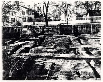 Photo 5818 - Wine Cellar from East
 Photo 5819 - Southeast Kitchen Addition from South
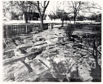 Photo 5820 - Close up of Kitchens from Southwest
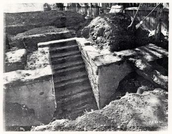 Photo 5822 - Wine Cellar Steps from North
 Photo - 5823 - "Storehouse" from Northwest
 Photo 5824 - "Shed" from South
 Photo 5901 - "Storehouse" from Northwest
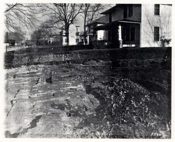 Photo 5902 - North Kitchen Chimneys from Northwest
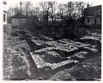 Photo 5903 - Forge and Chimneys from Northwest
 Photo 5904 - Service Entrance Foundations from Northeast
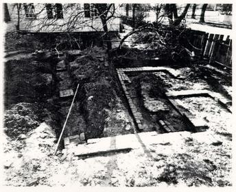 Photo 5905 - South Chimney from North
 Photo 5906 - Service Entrance Foundations from West
 Photo 5907 - East Wing Basement Stair from Southwest
 Photo 5908 - East Wing Chimney from South
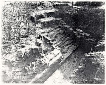 Photo 5910 - East Wing Basement Stair from Northwest
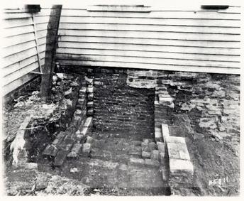 Photo 5911 - Basement Stair East of Service Entrance Foundations, from North
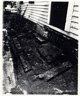 Photo 6113 - Porch Foundations on West Side of Main House
 Photo 6134 - Porch Foundations in Front of Main House
 Photo 6480 - Rear Mid-Section, Porch Foundation and Bulkhead Entrance
APPENDIX 4
ARCHAEOLOGICAL REPORT
1978
PEYTON RANDOLPH HOUSE
1978
INTERIM NOTES
BY
ERIC KLINGELHOFER
INTRODUCTION
From January 13 to March 22, the Department of Archaeology conducted excavations at the Peyton Randolph House, Lot 28, Area G, as part of a long term project to investigate and restore the outbuildings and gardens on the property. The work was supervised by William Henry and was restricted to the remains of an outbuilding located at the northwest corner of the property. Only a temporary grid was established for the area as assistance from C.W. surveyors was unavailable.
Excavations carried out by archaeologist James A. Knight in 1955 had located the foundations of this building and others along the western property edge. This structure measured 20'4" by 16'6" and had a corner chimney at the northeast wall angle. As the 1978 excavations were restricted to the west half of the building, we were unable to examine the chimney, but we did find that the layer of a gravel bed for a bus turn-around in 1975 apparently completely destroyed a chimney foundation which was attributed to the colonial period by Mr. Knight. It is possible, though unlikely, that evidence for this later occupation of the spot will have survived in the area immediately east of the 1978 trenches.
The excavation found four different groups of features and layers: the body of the building, with demolition debris within the walls; layers of occupation and construction material associated with the building; a series of fence post holes cutting through the building remains; and an earlier ditch ascribed to the Middle Plantation period. These groups will be described in detail within the body of this interim report.
All work was carried out under the protection of a wooden shed (originally constructed for repair of the windmill in 1977). The open sides of the shed were covered with plastic sheeting, and an electric/kerosine heater served to thaw the frozen ground and permit digging in relative comfort. Two discoveries were unwelcome intrusions into the excavation area. A C.W. lightning rod cable was found running inside the north edge of the trench. It protected the large tree near the site, and ran to utility pipes in North England Street. This has been moved to the north where further excavation in that direction may find it. Secondly, a utility trench which was ascribed to VEPCO (though it may have been a phone line) was found when excavations expanded 4'0" west of the property line. This cable was untouched and its trench was rapidly backfilled.
The excavation units for the 1978 season consisted of E.R. 2169-79-28.G. The site started with two ten foot square, E.R. 2169 and 2170, which were joined when the balk, E.R. 2171, was removed. E.R. 2172 was used for spoil. The excavation later expanded 4'0" to the west, with E.R. 2173, 74, and 75 representing the western areas. E.R. 2176 was used for a VEPCO utility trench, and E.R. 2177 and E.R. 2178 replaced E.R. 2170 and E.R. 2169 respectively, after the last letters were used up. E.R. 2179 was given to a layer of pipe stems found within the stratigraphic sequence west of Structure A.
At the end of the excavation, all layers west of the building were taken down to natural, if their removal would not undercut the wall remains. Boarding was firmly placed against the exterior face of the west wall to give it additional support. Finally, all exposed surfaces were covered with plastic, secured by nails.
Structure A
The object of the excavation was to explore the small, ancillary structure at the northwest corner of the Peyton Randolph lot. Based on the 1955 excavation, it measured 20'4" by 16'6". Rubble from the destruction of the building was found throughout its interior, but was left largely undisturbed, so that when excavations resume, it can be removed in a single operation. The wall remains were unusual, consisting of 4" wide brick foundations joining piers at the corners and at the center of each wall (see attached plan). The only intact pier was at the northwest corner, and measured 1'6" by l'0", but was "stepped" to the west. The southwest pier had been largely destroyed by a later post hole, but was 1'3" east-west. Post holes damaged the foundations in other places, destroying the north half of the center pier on the west wall. This pier was 10" wide and as much as 3'0" long. If so, it would not match the pier on the east wall as found by Knight in 1955. It may be, of course, that only the surviving bricks of the east pier were recorded, and its original form was larger. As the site slopes to the west, the walls followed this slope, with the west foundation one course deeper than the north and south foundations.
Stratigraphy Associated with Structure A
West of Structure A, C.W. trenching had cut through layers of occupational material associated with the structure, and in the act of exposing the foundations, the excavation had completely separated the building from the stratigraphy surrounding it. As the excavation unit E.R. 2175 contained portions of each layer associated with the occupation of Structure A, the excavation register identification letters for that unit will be applied to each layer. Please see the attached chart and schematic section.
No trace was found of the construction of Structure A, but a 2" inch thick layer of brown loam (E.R. 1775T) lay above a buff, sandy loam (E.R. 1775V) which sealed the natural and should represent the preconstruction soil, as it did not contain any artifacts. The brown loam, however, yielded a number of finds, including several sherds of white salt glaze ware which first appears ca. 1730. Cutting into this layer were two deposits: a yellow clay (E.R. 2175P) seems to have been used to fill in a depression southwest of the structure, and a pocket of brick chips and plaster fragments (not in E.R. 2175, assigned E.R. 2171J, 77F) sloped eastward toward the wall of Structure A, but had been completely removed by the 11" wide C.W. trench along the wall. It seems likely that the pocket continued to slope down toward the wall, and that the deposit represents a reconstruction or addition to the building. Note that plaster fragments among the finds indicates that the pocket was not filled with construction debris, as was originally thought, but with destruction debris, albeit on a limited scale.
The fairly flat surface presented by the infilling of these depressions was covered by a 1" thick layer of soft loam containing in places more pipe stems than soil (E.R. 2179-C). The distribution of pipe stems has indicated a point of dispersal about 8'0" from the northwest corner. Small pieces of bottle glass were found among the pipe stems; both give every indication of having been the result of daily sweepings out of a door and into the front yard and street. Preliminary analysis of the pipe stems undertaken by the Research Associate has yielded a mean hole diameter of 4.18 for 6265 fragments, with an extrapolated date of 1772.69. This date seems considerable later than is suggested by the other artifacts, which continue with the post-1730 white salt glaze ware as the latest datable object.
Covering the pipe stems, and containing a good quantity of stems also, was an ashy loam (E.R. 2175M,N) which spread throughout most of the area west of the building. This ashy soil was sealed by a 1" thick layer of loam containing mortar, plaster, brickbats, and what made the deposit exceptional, hundreds of pieces of delft tiles in both blue and purple designs (E.R. 2175L). The location of the individual fragments formed a pattern, suggesting that the tiles had been discarded through an opening in the west wall about 7'0" from the southwest corner, possibly an open window used by workmen making alterations.
Sealing the tile deposit was another widespread layer of ashy loam (E.R. 2175K) attributable to normal occupation of the building. This ashy soil in turn was covered by a deposit of brown loam containing numerous shell fragments (E.R. 2175J). A 3" thick mortar spread (E.R. 2175G) lay on top of the shell layer. It was sealed by a 2" thick layer of brown loam (E.R. 2175F,H) below a lens of red brick chips (E.R. 2175E). Above these layers was a disturbed brown loam (E.R. 2175A) which contained 19th century artifacts. The brick chips may have been caused by the 19th century demolition of one of the late colonial? structures nearby. The mortar spread, however, appears to represent the demolition of Structure A. Finds from the mortar, and the occupation layer below it, give a date after ca. 1740. The artifacts suggest a high standard of living, with quality wine glasses and pottery of Wieldon [sic] tortoise shell ware, and much export porcelain, including some of the rare "bianco supro bianco" variety. No sherds of creamware or of Wedgewood's green glazed or pineapple earthenwares have been found within the layers associated with the life of the building, suggesting that the house was no longer standing in the 1760s.
Interpretation of Structure A
Throughout the excavation of the little building, a major problem has been its identity. The placement of this structure at the far end of the lot, behind the other service buildings, is in apparent contradiction to the quite fine range of ceramics and glassware, not to mention the delft tiles found in association with it. We have suggested that Structure A served as a dower house for. Lady Randolph after Peyton was married in 1746. Her death soon after 1754 is close to the estimated demolition date of the house (ca. 1760), and the quantities of tea-related ceramics and the large number of pins recovered may denote a female occupant. Certainly the quality of items found suggests a person of considerable wealth or taste.
Evidence for the earlier life of the building pointed to a different occupant and a different sex. Refurbishing the interior had sealed earlier occupation levels with a spread of mortar, plaster, and tiles. In those levels, material thought to have been swept out toward the street consisted almost entirely of pipe stems and bottle glass, suggesting that drinking and smoking were customary activities. These finds, and the placement of Structure A away from the main house, have lead us to believe that the building may have served as a law office. Finds from the brick chips and plaster-filled pockets give a date in the 1730s, and as the plaster suggests a renovation rather than a construction, the building may have been standing for some years.
Thus the office could have been built by Sir John Randolph after acquiring the property in 1724, and its renovation may have followed his death in 1737. The office was converted to a dower house, for Lady Randolph by 1751, when it was recorded that Peyton was living in the Nicholson Street house (see Research Report for Colonial Lots 207 and 237, p. 10). The building was presumably pulled down in the late 1750s after Lady Randolph's death.
LATER FEATURES
Fence Lines
No post holes were found associated with Structure A. A series of fences lay along the west wall of the building, and appeared to turn east about 10' from the north property boundary. All post dated the destruction of Structure A, cutting into the foundation and into the rubble within its walls. It is possible that some of the fences indicated by the incutting holes continued north, out of the excavated area. A series of holes centered on a line 2'0" west of the foundation appear to be the latest because they cut the holes to the east. The western holes are at 9'0" intervals, and the placement of the next in the series would have been on the property boundary.
EARLIER FEATURES
There was only one feature which could be determined to have been in existence before Structure A. A ditch ran northwest-southeast across the site, continuing under the wall foundation of the building. The ditch was 4'0" wide and 1'02" deep with sloping sides and a curved bottom. It was filled with humic grey loam (E.R. 2173U,W), containing only a few nail fragments. The ditch can be no later than the first quarter of the century, after which the office was constructed. Indeed, the fact that the cutting runs totally askew to the orientation of the colonial city, suggests that it preceded the layout of the town, and so was probably a Middle Plantation field ditch.
| 2175A | = | 2169A; 70A; 71A; 73A; 74A |
| 2175E | = | 2173H; 2174B |
| 2175H,F | = | 2174C |
| 2175J | = | 2179Y; 71E; 73K; 74F |
| 2175K | = | 2169J; 70E; 71F; 73M; 74G |
| 2175L | = | 2170J; 71G; 73N; 74H |
| 2175M,N | = | 2169Z; 71H; 73P, R; 74J; 77D; 78A |
| 2175P | = | 2177E |
| 2175T | = | 2171K; 73S; 74K; 77G; 78D |
| 2175V | = | 2173T; 77H |
APPENDIX 5
POLLEN AND PARASITE ANALYSIS
POLLEN AND PARASITE ANALYSIS
OF THE PEYTON RANDOLPH SITE
WILLIAMSBURG, VIRGINIA
Karl J. Reinhard
Laboratory of Parasitology
Palynology Laboratory
Department of Biology
Texas A&M University
College Station, Texas 77843
INTRODUCTION
The utility of palynological analysis in archaeological research has long been recognised. Ecological changes, both dependent and independent of human activity, have been traced through palynological analysis (Martin 1963, Euler et al. 1979, Wycoff 1977). Dietary habits have also been elucidated by pollen studies (Adams 1980, Gish 1981, Williams-Dean and Bryant 1975, Reinhard 1985a). More innovative studies have focused on identification of agricultural plots (Berlin et al. 1977) and community growth (Hill and Hevly 1968). The utility of palynological research, however, is dictated at any given site by pollen preservation dependent on environmental conditions, pedology, and biological degradation (Helvy 1981, Bryant and Holloway 1982, Dimbleby 1957).
More recently, parasitological study has emerged as a new aspect of archaeological research. The theoretical background for such study has been clearly defined (Kliks 1983) and many studies have been accomplished (Fry 1977, Reinhard 1985b, Reinhard et al. 1985a). The utility of parasitological analysis is, however, effected by aspects of degradation, just is as the case with palynology.
With these thoughts in mind, palynological and parasitological surveys of soils from the Peyton Randolph site by the Williamsburg Foundation were undertaken. The primary goal of the analyses was assessment of the value of such research at the site.
METHODS
The basic procedures of pollen analysis have been established (Faegri and Iverson 1975). In its simplest form, palynological analysis involves the chemical digestion of soil constituents, leaving behind only the most durable remains which include pollen grains. Carbonates are dissolved by hydrochloric acid, most silicates by hydrofluoric acid, cellulose and hemicellulose by an acetolysis treatment (Erdtman 1960), and humic acids (partly decomposed organics) by potassium hydroxide or sodium hydroxide.
Beyond these basic techniques, there can be several modifications (Bryant and Holloway 1983). For example, sonication will break up some organics that do not normally dissolve in chemical treatment. Highly concentrated hydrofluoric acid can be used to more effectively dissolve silicates, and heavy density separation can be used to float pollen out of sediments that respond neither to chemical treatment or sonication.
To determine the number of pollen grains held in a soil sample, tracer spores of the fern Lycopodium are added. By knowing the number of tracer spores per gram of sediment, the proportion of spores to pollen grains provides a way to quantify the pollen yield per gram of soil. In the Williamsburg analysis, tracer spores were added to each soil sample processed.
The soils of Williamsburg are very resistant to pollen processing. Even though the basic procedures outlined above were applied, the amounts of inert organics and silicates were too great for effective analysis. A second processing was done involving more extensive treatment in concentrated (70%) hydrofluoric acid with initial sonication. This process also proved ineffective. Finally, a third extraction was performed utilizing heavy density separation in zinc chloride. Only in this final extraction did the soil samples clean sufficiently for analysis.
The extraction procedure found most effective with the Williamsburg soil samples is outlined below:
- 1) Two lycopodium tablets containing approximately 11,200 spores were added to 25 grams of soil.
- 2) The soil was treated with dilute hydrochloric acid until reaction with the carbonates stopped.
- 3) The soil/dilute hydrochloric acid mixture was transferred to a 150 ml beaker, the sediment was thoroughly agitated, and then allowed to sit for 30 seconds. Then the supernatant was screened through first a 0.5 mm screen and then a 0.15 mm screen.
- 4) The screened sediment was transferred to a 500 ml beaker and hydrofluoric acid was added. The sediment stayed in the hydrofluoric acid for 30 hours.
- 5) The sediment was processed through three distilled water washes.
- 6) After the washes had thoroughly cleaned the sediment of hydrofluoric acid, it was transferred to a 50 ml centrifuge tube and zinc chloride flotation mixture was added. (The mixture consists of a 10% solution of hydrochloric acid in which zinc chloride is dissolved until a specific gravity of 1.9 is obtained). The sediment was centrifuged at about 1,950 r.p.m. for 30 minutes.
- 7) From the upper portion of the sediment, polleniferous fluid was pipetted into a 50 ml beaker, and the fluid was diluted with distilled water.
- 8) A standard distilled water wash, followed by a glacial acetic acid wash, was performed.
- 9) Acetolysis mixture, consisting of one part sulphuric acid and 9 parts acetic anhydride, was added to the centrifuge tube containing the sediment and the tube was placed in boiling water for 20 minutes.
- 10) Standard acetic acid and distilled water washes were performed.
- 11) A final treatment of the sediments in 5% potassium hydroxide was done.
- 12) A series of standard water washes was were performed until the supernatant was clear.
- 13) The sediment was transferred to vial for study.
For statistical purposes, it is necessary to count a minimum of 200 pollen grains per soil sample. Most Williamsburg samples were found to contain too few to effectively make a 200 grain count. Nonetheless three microscope preparations were counted from each sample of extracted sediments. Usually, a 200 grain count can not be made form samples containing less than 1,100 pollen grains per gram of soil due to the tremendous time investment in isolating the identifying enough gains for statistical purposes as well as to erosional and degradational factors which destroy certain pollen types more easily than others. This results in pollen counts that are not representational of the original pollen rain deposited in the soils. Identification of grains was based on published keys and on comparison with the pollen collection on file in the Laboratory of Palynology, Texas A&M University.
Parasite analysis is relatively new as applied to archaeological sites. Techniques for the extraction of parasites (primarily the eggs of tapeworms, roundworms, and flukes) are varied. Some analysts have effectively applied clinical techniques to prehistoric soils and coprolites. When parasite eggs are partially decomposed or severely dessicated, I have found clinical techniques inadequate. It is necessary to dissolve carbonates in the soil that would otherwise cement the eggs in the soil matrix. It is also necessary, in certain types of soil, to dissolve the heavier silicates to allow effective flotation. My technique, which I now find applicable to both coprolites and archaeological soils, employs treatment of the soils in hydrochloric acid and, depending on silicate content, sometimes hydrofluoric acid. The soils are then reduced to the point at which the zinc chloride heavy density flotation fluid will effectively levitate even poorly preserved ova.
RESULTS
Of the 16 soil samples submitted for pollen study, only one contained sufficient pollen to make a 200 grain count. The samples submitted for analysis are listed in table I with the number of pollen grains present per gram of soil.
| Sample # | Provenience | Number of grains per gram |
|---|---|---|
| 28-G- | ||
| 1037 III | Planting Bed I, 2nd level | 40 |
| 1069 III | Planting Bed I, 4th level | 124 |
| 1044 II | Planting Bed II, 2nd level | 108 |
| 1075 I | Planting Bed II, 3rd level | 38 |
| 1484 A | Planting Bed III, (refuse) | 1,684 |
| 1596 R | Planting Bed III, (refuse) | 42 |
| 1969, ABEF | Planting Bed IV, fill | 155 |
| 2067 | Planting Bed IV, (refuse) | 29 |
| 1626 | Control (subsoil between PB III&IV) | 88 |
| 183 R | Dark brown soil, interior Str. A | 66 |
| 1311 | Control (subsoil within Str. A) | 19 |
| 28-H- | ||
| 334 | Marl Layer | 231 |
| 300B | Control (refuse layer) | 82 |
| 692 | Control (clean brown layer) | 107 |
| 703 | Ash layer | 10 |
| 811 | Control, (subsoil east of Str. K) | 38 |
As can be seen, only sample 28-G-1484 A contained sufficient pollen for a complete 200 grain count. The pollen grains found in for all other samples are presented in Table 2. The pollen count from sample 28-G-1484 A is presented in Table 3. Common names of the plant taxa found in the pollen analysis are presented in Table 4.
| Sample # | Pollen Grains Found |
|---|---|
| 1037 III | 1 Pinus, 1 Ligulafloreae |
| 1069 III | 1 Pinus 3 Ligulafloreae, 1 ChenoAm, 1 Betula |
| 1044 II | 5 Pinus, 5 ChenoAm |
| 1075 I | 1 Ligulafloreae, 1 ChenoAm, 2 Primulaceae, 3 low spine composite |
| 1596 R | 1 Pinus, 1 ChenoAm, 1 Betula, 2 low spine composite |
| 1969 ABEF | 1 low spine composite |
| 2067 | 1 pinus, 1 Salix, 1 Ostrva/Carpinus |
| 1626 P | 2 Pinus |
| 183 R | 3 Pinus |
| 1311 | 1 Pinus, 1 low spine composite |
| 334 | 13 Pinus, 3 unidentifiable grains |
| 300 B | 2 Pinus, 3 ChenoAm, 1 Artemesia, 1 Carva, 1 low spine composite |
| 703 | 1 Pinus |
| 811 | 3 Pinus, 1 ChenoAm |
| Taxon | Grain # | Percentage of Total |
|---|---|---|
| Acer | 4 | 1 |
| Betula/Myrica | 5 | 2 |
| Carva | 1 | <1 |
| Castanea | 1 | <1 |
| Celtis | 1 | <1 |
| ChenoAm | 6 | 2 |
| Diospyrus c.f. | 1 | <1 |
| Fraxinus | 2 | 1 |
| Ilex | 1 | <1 |
| Juglans | 4 | 3 |
| Juniperus | 7 | 3 |
| Ligulafloreae | 3 | 1 |
| Liquidambar | 20 | 7 |
| Penstamon c.f. | 1 | <1 |
| Ostrva/Carpinus | 8 | 3 |
| Pinus | 141 | 53 |
| Platanus | 1 | <1 |
| Portulaca | 4 | 1 |
| Quercus | 11 | 4 |
| Rosaseae | 11 | 4 |
| Umbellifereae | 1 | <1 |
| Vibirnum | 2 | 1 |
| Viola c.f. | 1 | <1 |
| Unidentifiable | 19 | 7 |
| Unknown | 9 | 3 |
| Total | 265 | 100 |
| Scientific Name | Common Name |
|---|---|
| Acer | Maple, probably Sugar Maple |
| Betula/Myrica | Birch or Sweet Gale |
| Carva | Pecan and/or Water Hickory |
| Castanea | Chestnut |
| Celtis | Hackberry |
| ChenoAm | Plants in the Goosefoot or Pigweed Family |
| Diospyros | Common Persimmon |
| Fraxinus | White Ash |
| Ilex | Holly |
| Juglans | Walnut |
| Juniperus | Cedar or Juniper |
| Ligulafloreae | Probably Dandelion or Chicory |
| Liquidambar | Sweet Gum |
| Penstemon | Probably Beard-Tongue |
| Ostrva/Carpinus | Hop-Hornbeam or Blue Beech |
| Pinus | Pine |
| Plantanus | Sycamore |
| Portulaca | Purslane |
| Quercus | Oak |
| Rosaceae | Rose Family (Apple, Chokecherry, Avens) |
| Umbellifereae | Carrot Family |
| Viburnum | Arrow-wood |
| Viola, C.F. | Violet |
| Unidentifiable | Grains too eroded, collapsed, or torn for recognition |
| Unknown | Grains well preserved but unknown to author and found neither in references nor in comparative collections |
| Salix | Willow |
| Artemisia | Wormwood, sage |
| Low Spine Composite | Wind pollenated plants in the Composite Family such as Grondsel and Ragweed |
No evidence of parasite remains was found although all samples were tested.
DISCUSSION
Pollen Preservation in Williamsburg
Sporopollenin is the durable compound that results in the preservation of pollen grains once they are incorporated in soils. It is generally true that those pollen types which incorporate the greatest amounts of sporopollenin in their structure are the most durable types (Havinga 1964). The most durable types include Pinus , ChenoAm, grass, and the composite types (high spine, low spine, and Ligulafloreae). Examination of Table 2 demonstrates that in the soil samples containing insufficient pollen for a standard 200 grain count, Pinus , ChenoAm, and composite types are most often noted. This suggests that the soils of Williamsburg present conditions that differentially destroy certain pollen types. Factors that have been attributed to the destruction of pollen are pH, oxidation potential, repeated wetting and drying, and biological degradation. The pH measurements of the soil samples provided by the archaeologists ranged from 6.85 to 7.55. Early work by Dimbleby (1957) indicated that soils with pH greater than 6.0 did not contain enough pollen for analysis. Later work by Martin (1963), however indicated that pollen was present in sufficient quantities for analysis up to a pH of 8.9. Consequently, I think it unlikely that pH plays much or a role in pollen degradation at Williamsburg.
Another factor of preservation explored by Tschundy (1969) is oxidation potential (Eh). Eh is determined by the nature of decomposition in the environment. Anaerobic decomposition results in low Eh values and good pollen preservation. Conversely, aerobic decomposition results in high Eh and poor pollen preservation. In most of the Williamsburg samples, fungal spores were very common. The spores range from the most primitive Fungi Imperfecti, which are involved in the decomposition of simple compounds, to advanced Basidiomycetes, which are involved in the decomposition of complicated molecules such as cellulose and lignin. Since fungi are the main decomposers in an aerobic environment, it is undoubtable that high Eh was a factor in pollen decomposition. It is important to note that fungi have been implicated directly as pollen decomposers. Soil phycomycetes have been specifically noted (Goldstein 1960) as pollen decomposers.
Holloway (1981) has clearly shown that mechanical degradation is of major significance with regard to pollen preservation. Repeated wetting and drying has a strong effect on the integrity of pollen grains. It is probable that watering of the planting beds and drying of surficial soils, perhaps after hoeing, is a major factor responsible for the destruction of the pollen grains in planting bed soils.
Although these factors are probably at work in degrading pollen, another reason for the insufficient pollen presence in most soils is the washing of pollen out of the soils. While screening the soils, I noticed that most sand grains were trapped in the 0.15 mm screen. This shows that the soil constituents, independent of organics, are very coarse. Although not commonly noted as a factor of pollen recovery, pollen grains can be washed out of coarse soils by rainfall. It is my belief that a major factor resulting in poor pollen recovery from the Peyton Randolph excavations was the percolation of pollen down and out of large grained soils.
To evaluate the preservation of pollen in soils that contained low pollen levels, I counted through a full gram of soil from sample 1969 ABEF. Two work days of microscopic examination were necessary to complete the count. Only 146 grains were found (Table 5), but the good preservation of many grains indicates that factors other than degradation are involved in low pollen yield. A large diversity of pollen types was found in the sample and evidence of degradation in the form of collapsed, torn, or eroded grains was infrequent. This count indicates that biological, chemical, and mechanical aspects of degradation are at work in the destruction of some grains, but percolation of pollen grains out of the soil by water action is also important.
With respect to the other soil samples, 28-G-1484 A is enigmatic. This sample contained an abundance of well preserved pollen grains. I suspect that the nature of the soil sample, which was from a refuse layer, helped preserve the pollen by virtue of high organic content, no tilling, and a finer soil matrix which was capable of holding pollen despite washing.
| Taxon | # of grains counted |
|---|---|
| Acer | 1 |
| Betula | 1 |
| Brassicaceae | 1 |
| Carva | 9 |
| Ceanothus c.f. | 1 |
| ChenoAm | 16 |
| Cornus | 1 |
| High Spine | 2 |
| Juglans | 9 |
| Juniperus | 2 |
| Ligulafloreae | 3 |
| Liquidambar | 21 |
| Low Spine | 3 |
| Ostrva/Carpinus | 1 |
| Pinus | 54 |
| Poaceae | 1 |
| Quercus | 8 |
| Rhamnus | 2 |
| Ribes | 1 |
| Salix | 1 |
| Ulmus | 2 |
| Unidentifiable | 6 |
Environmental Interpretations
The preservation of pollen in sample 28-G-1484 provides a glimpse of the 18th century environment of Williamsburg (Table #3). Only 8% of the pollen came from herbaceous plants, while 81% of the pollen came from arboreal taxa. This indicates that the environment was dominated by a forest. The shade limited the growth and diversity of understory species such as grasses and herbs. This is stark contrast to an urban environment where herbaceous species thrive in a relative absence of trees.
The forest was a mix of broad leaf deciduous trees and conifers. Although pine pollen dominates the pollen spectrum, this does not indicate that pine dominated the forest. Pines are especially prolific pollen producers. Up t a million pollen grains per anther are produced by certain pines; however other tree species, especially those pollinated by insects, produce only several hundred or several thousand pollen grains per anther. Considering relative pollen productivity, the forest in the vicinity of the site was dominated by sweet gum, oak, and pine, with a mixture of ash, holly, walnut, maple, willow, sycamore, cedar, and other trees and shrubs. Due to insufficient preservation, the Betula/Myrica identification proved problematic. Therefore, both genera were included in one classification. It is less likely the Betula (birch) is present considering the fact that this is a northern or highland growing tree. Also, Ostrva (hop-hornbeam) and Carpinus (blue beech) produce pollen grains that are nearly identical so it is impossible to tell which tree is represented. It is very likely that some of these trees were grown as ornamentals (Dutton 1979).
Whether or not trees were grown as ornamentals, the pollen record clearly demonstrates that a forest dominated the environment of Williamsburg in the second decade of the eighteenth century.
Recommendations for Future Palynological Research
The poor pollen recovery from the Peyton Randolph soil samples indicates that any future research should be highly selective. Because of the limited potential of the soils for palynological research, I believe that the information yield from extensive study of soil samples will not justify the monetary output necessary for analysis.
The pollen yield from sample 28-G-1484 A, however, indicates that certain soils do contain sufficient pollen grains to warrant limited expenditure of monies on pollen analysis. I suggest that palynological research should be applied to privy soils, refuse deposits, vessel contents, or any other soils that have good depositional integrity.
Parasitological Remains
Several parasitological tests were applied to each soil sample. None produced parasite remains. In my analyses, any evidence of intestinal worms (helminths) would have been found had the soils been contaminated with excreta at some time in the past. It is probable that the inhabitants of the site utilized a privy for defecation rather than depositing feces in other refuse broad-scattered throughout the yard. This disposal pattern was encountered in the analysis of Queen Anne Square, a Revolutionary Period community in Newport, Rhode Island (Reinhard et al. b). Therefore, future investigations should be limited to soils excavated from identifiable privies.
Helminth parasitism was an unavoidable aspect of life for Europeans and Colonists. The climate of Williamsburg is well suited to the survival of many helminths including whipworm, giant intestinal roundworm, and hookworm. The soil conditions of Williamsburg are also conducive to the preservation of helminth ova as witnessed by the presence of fungal spores in the soils. Fungal spores, like helminth eggs, are chitinous. The preservation of the spores indicates that excellent preservation of helminth eggs is probable. It would be very interesting to examine Williamsburg privy soils for evidence of human parasitism, if privies are encountered in future excavations.
REFERENCES
- Adams, K.R. (1980) Pollen, Parched Seeds, and Prehistory: A Pilot Investigation of Prehistoric Plant Remains from Salmon Ruin, a Chacoan Pueblo in Northwest Mexico. Eastern New Mexico University Contributions to Anthropology 9.
- Berlin, G.L., Ambler, J.R., Hevly R.H. and Schaber G.G. (1977) Identification of a Sinaqua agricultural field by aerial thermography, soil chemistry, pollen/plant analysis, and archaeology. American Antiquity 42:588-560.
- Bryant V.M., and Holloway, R.G. (1983) The role of Palynology in Archaeology, chapt. 5 in Advances in Archaeological Method and Theory, vol. 6, (M. B. Schiffer, ed.) Academic Press, Inc. New York.
- Dimbleby, G.W. (1957) Pollen analysis of terrestrial soils. New Phytologist 56:12-68.
- Dutton, J.P. (1979) Plants of Colonial Williamsburg, The Colonial Williamsburg Foundation, Williamsburg.
- Erdtman, G. (1960) The acetolysis method: a revised description. Svensk Botanisk Tidskrift 54:561-564.
- Faegri, K. and Iverson J. (1975) Textbook of Pollen Analysis. Hafner Press, New York.
- Fry, G.F. (1977) Analysis of Coprolites from Utah. University of Utah Anthropological Papers 97.
- Gish, J.W. (1981) Pollen Studies in the Palo Verde Archaeological Project Hohokam settlement at the Confluence. Museum of Northern Arizona Research Paper 20.
- Goldstein, F. (1968) Degradation of pollen phycomycetes. Ecology 41:543-545.
- Havinga, A. J. (1964) Investigations into the differential degradation of pollen and spores. Pollen et Spores 6:621-635.
- Hevly, R.H. (1981) Pollen production, transport, and preservation: potentials and limitations in archaeological palynology. Journal of Ethnobiology 1:39-54.
- Hill, J.N. and R.H. Hevly (1968) Pollen at Broken K Pueblo: some new interpretations. American Antiquity 33:200-210.
- Holloway, R.G. (1981) Preservation and experimental diagenesis of pollen exine. Ph.D. Dissertation, Department of Biology, Texas A&M University, College Station.
- Klilks, M. (1983) Paleoparasitology: on the origins and impact of human-helminth relationships. Chapt. 11 in Human Ecology and Infectious Diseases, Academic Press, New York.
- Martin, P.S. (1963) The Last 10,000 Years. University of Arizona Press, Tucson.
- Reinhard, K.J. (1985a) Helminth Examination of Coprolites: The Cultural-Ecology of PreHistoric Parasitism on the Colorado Plateau. M.A. Thesis, Northern Arizona University, Flagstaff.
- (1985b) Parasitism at Antelope House, a puebloan community in Canyon de Chelly. In Health and Disease in the Prehistoric Southwest (Merbs, C., ed.), Arizona State University Anthropological Research Papers 39.
- Reinhard, K.J., J.R. Ambler, and McGuffie, M. (1985a) Diet and parasitism of Dust Devil Cave. American Antiquity, in press.
- Reinhard, K.J., Mrozowski S., and Orloski K. (1985b) Pollen and Parasites: the biological nexus in historical archaeology. Paper presented at the annual meetings of the Society for Historical Archaeology.
- Tschundy, R.H. (1969) Relationship of palynomorphs and sedimentation. In Aspects of Palynology, pp. 79-96, (Tschuny, R.H. and Scott, R.A. eds.). Wiley Press, New York.
- Williams-Dean, G. and Vaughn M. Bryant (1975) Pollen analysis of human coprolites from Antelope House. The Kiva 41:97-112.
- Wycoff, D.G. (1977) Secondary forest succession following abandonment of Mesa Verde. The Kiva 42:215-232.
APPENDIX 6
MACROFOSSIL ANALYSIS
A REPORT OF THE ANALYSIS OF MACROFOSSIL REMAINS
FROM THE PEYTON RANDOLPH HOUSE,
WILLIAMSBURG, VIRGINIA
By
Stephen A. Mrozowski
Archaeobotanical Consultant
INTRODUCTION
The analysis of seeds and other plant macrofossils has been a major part of archaeological research since its beginnings as a discipline during the nineteenth century (Kunth 1826; Heer 1866). Since that time, archaeologists seeking answers to questions concerning prehistoric plant use and the origins of agriculture have relied upon the microscopic remains of plants for evidence (e.g., Dimbleby 1978). Within the past two decades two very important trends have emerged in the study of plant remains in archaeology. The first of these has been the application of these data to reconstruct past landscapes (e.g., Jones and Dimbleby 1981). The second has been the emergence of contextual studies, the main goal of which has been to link intra-site patterning to human behavior (e.g., Dennell 1972, 1976; Hubbard 1976; Hillman 1973, 1981). The "behavioral approach" as Jones (1985:108-111) has recently noted is now the main focus of most archaeobotanists' work in Europe.
While the importance of incorporating plant studies into, archaeological research has a long tradition among pre-historians and ethnobotanists in North America (see Ford 1978), the same is not true for historical archaeologists. Perhaps because of the emphasis placed 2 upon the study of the documentary record, historical archaeologists have ignored many of the analytical avenues traveled by pre-historians. This may prove unfortunate because recent studies suggest the potential this approach holds for providing information concerning the reconstruction of past landscapes and diet (Kelso and Schoss 1983; Mrozowski 1983).
A major stumbling block to the analysis of plant remains from archaeological contexts is the problem of differential preservation (e.g., Green 1982; Minnis 1981; Keepax 1977). These difficulties include differentiating between seeds deposited in antiquity as the result of human activity and those that are the product of post-depositional disturbance. One answer to this dilemma is to accept only charred seeds as being culturally relevant (Minnis 1981; Keepax 1977). While this may be appropriate in some cases, there are archaeological contexts that are characterized by aerobic environments that promote organic preservation. These include features such as wells, drains and privy pits. Seeds recovered from Roman and Viking sites in York (Hall et al. 1980; Hall and Kenward 1982) have shown remarkable preservation.
Urban sites, like those in York, often contain archaeological features such as wells and privies that can be counted upon for well preserved organic remains. The predominance of features like privies and drains on urban 3 sites reflects the need for such facilities brought on by the spatial constraints of city life. One unfortunate by-product of this situation is that urban sites are given priority by analysts because of their productivity. What is unfortunate is that rural sites and non-water-logged deposits in cities are often ignored. This state of affairs is unlikely to change without some experimenting with contexts such as those just noted. The Peyton Randolph House provides just such a testing ground.
The main focus of our research at the Peyton Randolph House was to reconstruct the site landscape. This involved reconstructing the plant communities that characterized the yard during the eighteenth century, as well as determining function of four features that may have served as planting beds. This report provides a tabulation of the seeds identified from the four planting beds in the yard and an analysis of those findings. As the results indicate, the value of this kind of research on sites like the Peyton Randolph House reflects the overall integrity of the site itself. As the findings suggest, the site appears to be heavily disturbed although some interesting information was obtained from the material recovered form the planting beds. While evidence of wide-scale disturbance was quite clear, data pertaining to the use of yard space and possible dietary information was recovered as a result of this analysis.
METHODS
Soil samples were collected by the archaeologists from features located in the yard. These were matched by a like number of control samples. These samples were then processed at Colonial Williamsburg by flotation (see other section). The floated samples were then scanned for non-seed material such as roots and nitrogen nodules. An initial sorting was then carried out at Colonial Williamsburg. Once this was completed samples of sorted specimens were provided the author. Each specimen was subjected to microscopic analysis to determine the identity of seeds at the family level. This initial phase was followed by a second round of analysis in hopes that species identification could be obtained. These identifications were compared with seed specifications provided by manuals and type collection samples. In some instances it was possible to identify seeds to the species level. All seeds were quantified precisely with the exception of the genus Rubus, which is a member of the Rose family and includes blackberry and northern Dewberry. Representatives of this genus are often recovered in large numbers from archaeological contexts. In this instance approximate numbers are provided along with other information in Table 2.
RESULTS
This discussion will focus on archaeological contexts as opposed to individual samples. Table 1 contains a precise tabulation of all the seeds identified from each sample. By concentrating on archaeological contexts as opposed to discussing individual samples emphasis will be placed upon the interpretation of the floral material as it pertains to the overall site. It is hoped that this will be more fruitful than a discussion of the plants alone.
28H 780
This feature consisted of a black ash deposit around the north hearth. Four Prunus specimens were found in this deposit. Prunus contains the many members of the Cherry family. These fragments were badly charred and therefore species identification was impossible. The fact that the specimens were charred suggests they may have been prepared as part of a cider or that they were thrown into the hearth after being consumed.
28H 551
This layer of Yellow Clay contained five identifiable specimens. Two of these were members of the Caryophyllaceae family, better known as Pinks. These perennials flourish in nitrogen-rich, disturbed soils 6 (Fernald 1970:631-634). They are commonly found in garden plots. The species appears to be Silene virginica that is well known for its deep red to crimson flowers. The presence of these seeds suggest they were being grown somewhere in the vicinity if not directly in the yard.
The other seeds identified from this context can only be attributed to the family Grameceae, the large family of grasses. Their presence should certainly be expected in any yard deposit dating to the eighteenth century onward. Grass seeds and those of Pinks suggest a yard that was subject to disturbances but that was probably not being used for keeping animals or intensive cultivation.
28H 393A
This shell and brick bat filled ditch contained seeds of Caryphyllaceae and Rubus. Both of these perennials are found in disturbed soils, especially along features like fences or building foundations. These plants are creepers and can be expected to grow along fences and buildings. Pinks are often allowed to grow as ornamentals in such contexts.
28H 313Bb
This refuse layer contained a number of wood fragments and a single Sambucus seed. Sambucus canadensis, commonly referred to as Elderberry, is often 7 found in yard deposits but is not considered as troublesome as Rubus. It was used commonly in the making of cider and wine, both of which served as food preservatives during the eighteenth century. Sambucus was found in relatively large numbers in privies excavated in Newport, Rhode Island (Mrozowski 1983).
28H 119
This large pit contained a single charred Cucurbitaceae fragment that represents either squash or pumpkin. Because the specimen is charred, a more exact identification is difficult. However, due to its context, this is probably an example of a food product. Members of the family are often recovered from archaeological sites and are considered good evidence of on-site cultivation.
Contexts 28G 1619/1752/1795/1846/1862
This series of features included a layer of marl outside structure E (1619); a layer of brick plaster and mortar rubble (1752); a robbers trench (1785); a pit feature that was located in the interior of structure B (1846), and another pit feature (1862). These features all contained large numbers of Rubus seeds. Blackberry plants grow ubiquitously in disturbed areas, along fence lines and in garden plots. They are often found in yards. The berries of these plants serve a variety of uses. They 8 can be eaten raw, used in the preparation of wines and ciders or used in baking. Throughout the period the Peyton Randolph House was occupied it probably contained Rubus plants in abundance. Rubus is an active and stubborn colonizer which is the chief reason it is among the most common seed found in archaeological deposits from sites of all periods.
Planting Beds
The vast majority of seeds that were recovered from the Peyton Randolph House were from the four features alleged to be planting beds. These features were found at the rear of the house lot in close proximity to one another. Instead of discussing individual samples from the planting beds. All samples from each bed will be dealt with as a feature assemblage. Furthermore, the four beds will be considered as a group due to the noticeable similarity between them in terms of what seeds they contained.
Planting Bed l
This feature was excavated in arbitrary levels, but based upon the seeds recovered from the individual levels it is difficult to recognize any significant stratigraphic differences. Level one contained seeds of the Rubus, Chenopodium and Brassica families. Level 2 contained a single Cucurbit seed that may be Watermelon. Level 3 9 contained Pokeweed, Cucurbitaea and Rubus seeds with Level 4 having Rubus and Acalypha seeds. Acalypha is a member of the Spurge family that includes three-sided Mercury and Copperleaf, both of which are found in Virginia. These perennial herbs are found in disturbed, agricultural soils.
With the exception of the Cucurbit seeds, all of the plants represented in planting bed 1 were secondary succession colonizers. Brassica that includes rapes and mustards is found in meadows and fields throughout the Eastern United States. Rubus (blackberry), Chenopodium (gooseleaf) and Pokeweed are found in actively cultivated soils and those recently abandoned. It would appear therefore that these seeds are probably indicative of the community that characterized these beds after they were used for growing purposes or they represent the weeds that were colonizing the beds while under cultivation. Another possibility is that all of the plants with the exception of the Cucurbit and Acalypha represent later disturbance of the features.
Planting Bed 2
This bed was also excavated stratigraphically by arbitrary levels. Due to the limited value, of discussing the results in stratigraphic terms the seeds recovered from this bed will be described as a group. Planting bed 10 number 2 contained seeds of the Acalypha, Rubus, and Rumex families. Rumex contains the many Dock and Sorrels found in fields and garden areas. Jefferson referred to Rumex acetosa as a Sorrel and planted it among his "salad" plants (Betts 1981:58, 399).
In addition to these rather common perennials this bed also contained Pokeweed, Liriodendron tulipifera (Tuliptree) and a number of badly charred seeds that could be Asparagus (Asparagus officinalis) or a large Legume such as beans or pea. They are the correct size and general shape for asparagus but because they are poorly preserved it is difficult to determine the presence of the exterior dimple that is so prominent on Asparagus. If not Asparagus, then this seed represents a rather large legume that may have been cultivated in the beds. The Tuliptree seed is representative of a tree that is common in the Williamsburg area today as it was during the eighteenth century. These trees can reach great heights and would have, provided excellent shade for the yard.
Planting Bed 3
This bed is larger in size than either bed 1 or 2 and it contained a number of different plant seeds. This bed contained Oxalis stricta (sheep sorrel) Rubus, Pokeweed, Taraxacum officinale (Dandelion), Physalis virginiana (Groundcherry) and a number of unidentified 11 seeds that appear to be Tarweed, but that could be some member of the Compositeae or Rosaceae families. The importance of the Oxalis lies in its preference for nitrogen rich soils and for shade (Fernald 1970:944-945; Braun-Blanquet 1964:37). These yellow petalled low lying sorrels are often found in gardens and are allowed to grow due to their pleasant appearance. They do, however, have a tendency for thriving in crowds and can effect other plants in their proximity. Physalis is a similar plant. Both of these ground cover plants will begin to creep if fences are available.
In this case as with beds 1 and 2 we are left asking whether these are the seeds of plants that represent secondary succession or species present during the period when the beds were in active use. This is a very difficult question to answer because plants like sorrels are often allowed to thrive in garden plots. In this sense it may be impossible to differentiate between their colonizers before or after the beds were in active use.
Planting Bed 4
This bed contained a number of seeds off the large Compositeae family that include thousands of weeds and flowers as well as Physalis, Rubus, Trifolium, Polygonaceae, Oxalis stricta, Pokeweed and Acalypha. The plants contained in this assemblage are surprisingly 12 similar to those found in planting bed 3 with the exception of Polygonaceae (buckwheat) and Trifolium that includes sweet and white clover. This bed also contained a number of large charred legume seeds that are identical to those that may be asparagus discovered in planting bed 3. The Compositeae may represent flowers, but it is difficult to say given the thousands of members of this family in the Virginia area alone. The presence once again of oxalis stricta suggests that the beds were well shaded and that they contained nitrogen rich soils.
Discussion
Overall, the plants represented in most of the archaeological contexts at the Peyton Randolph House are familiar to those found growing in the area today. This should not come as a surprise, however, given that plant communities have probably changed very little in the last two hundred years. Most of the information that can be gleaned from these data relate to the general setting of the yard. Based upon the presence of both Oxalis (sorrel) and Physalis (groundcherry) it wold appear that the yard was relatively well shaded. The idea that the planting beds were used for asparagus or other legunainous species is supported indirectly by a community of plant remains that grow well in nitrogen rich soil and in shade, conditions both suitable for asparagus. This, coupled 13 with what may be asparagus seeds, provides at least some support for this possibility.
The presence of Cucurbit remains in contexts that may have been associated with food preparation or disposal indicates that members of this family were being consumed by the site's inhabitants. Their presence in the planting beds suggests they could have been cultivated in the beds or that they represent refuse used as a mulch or compost. The latter of these two possibilities is the most likely given the size of the beds and the way Cucurbits grow. Members of this family send out long runners that can quickly dominate a garden plot. Furthermore, nothing so elaborate as the planting beds is necessary for growing plants like squash or pumpkin. Asparagus, on the other hand, would require a well controlled, moist, rich environment in which to flourish. Randolph (1826:3-5) suggests the use of dung or other waste products in the propagation of asparagus so the presence of some plant material should be no surprise. In fact, many of the weed seeds recovered from the planting beds represent plants that would have been a nuisance to gardening, but that could have been added to compost used as fertilizer. Ethnoarchaeological research recently conducted in Massachusetts indicates that garden weeds such as Pokeweed, Chenopodium or Rumex (Dock) as well as many 14 creepers (Rubus and Physalis) are removed only to be redeposited as fertilizer.
If we compare the seed assemblages of the four planting beds it is possible to discern some differences. The overall breakdown is presented below in Table 1. With the exception of the Cucurbit and the possible Asparagus all of the seeds found in the planting beds represent weeds. There are, however, some subtle differences between beds 1 and 2 and beds 3 and 4 that may be important. One distinction is the lack of Cucurbit in either bed 3 or 4. The other difference is the presence of Trifolium and Taxacum in beds 3 and 4. Both clover and dandelion are grass plants that would not be anticipated in gardens under cultivation. This leads to the inference that the assemblages of beds 3 and 4 represent post-cultivation communities while those in 1 and 2 may reflect at least some of the plants that were present while the beds were being used. This is a tenuous assertion that must be approached with caution. Oxalis stricta, for example, is a plant that would be anticipated in cultivated soil. What is most likely is that beds 3 and 4 have been more disturbed than either l or 2, and that some original community members are represented.
Other contexts within the site provide further information, but like the planting beds, they too present difficulties concerning their interpretation. The four 15
| PLANTING BED 1* | PLANTING BED 2* | PLANTING BED 3 | PLANTING BED 4 |
|---|---|---|---|
| LEVEL 1 | LEVEL 1 | Rubus | Trifolium (clover) |
| Rubus | Possible Asparagus | Pokeweed | Rubus |
| Chenopodium | Acalapha | Taxacum (dandelion) | Polygonaceae |
| Brassica | Hackberry | Oxalis | |
| Physalis | Pokeweed | ||
| LEVEL 2 | LEVEL 2 | Rosaceae | Acalepha |
| Cucurbit | Cucurbit | Physalis | |
| Rubus | Possible Asparagus | ||
| LEVEL 3 | Possible Asparagus | ||
| Pokeweed | |||
| Cucurbit | LEVEL 3 | ||
| Rubus | Pokeweed | ||
| Acalapha | |||
| LEVEL 4 | Tulip tree | ||
| Acalapha |
The only additional family of note that is represented in the site assemblage is the Caryphyllaceae found in the brick bat and shell filled ditch as well as in the layer of yellow clay. The Caryphyllaceae family known commonly as "Pinks" is a pleasant flowering runner that is often promoting along fence lines, walls or the sides of houses.
On the basis of the information as a whole it would seem that the four features within the yard did function as planting beds. Compost was used to fertilize the beds that contained domestic refuse and weed remains probably collected in the yard. Answers to the, question what was grown in the beds remain elusive. The large, asparagus-like seeds may indicate asparagus was cultivated in at least two of the beds. If not asparagus, then we can at least assume some kind of large legume, a bean perhaps. 17 The presence of Oxalis suggests a shaded area, which would be conducive for asparagus. No definitive answer can be offered unfortunately.
CONCLUSION
It is difficult to draw any sound conclusions from the seeds recovered from the Peyton Randolph House because it would appear that the site is extensively disturbed. This contention is supported by both the archaeology and the plant remains found on the site. The presence of Rubus seeds in almost every context is testimony to the activity of humans in shaping the site. Plants are among the most sensitive indicators of human activity. The challenge is discerning what the activity was and when it took place. This is particularly true of the planting beds. As much as Randolph (1826:3-5) exhorts his readers to rid their beds of weeds, this is virtually impossible. Therefore the presence of active colonizers such as Chenopodium, Rubus, Oxalis and Physalis does not necessarily indicate post cultivation succession. Rumex is often found in non-active areas while plants such as Chenopodium are, more often found in soil under cultivation. However, beyond this, little is known about what weeds were present in eighteenth century gardens.
The results of the analysis have been somewhat 18 disappointing in that the majority of seeds are from what appear to be mixed contexts. The seeds suggest this quite strongly. The mix of uncharred weed seeds with those of charred legumes in the planting beds may indicate successional shifts or disturbance. The conditions indicated by the plant remains are not unlike those present on the site today with the possible exception of the Tuliptree seed. This tree is quite common, but whether its presence represents recent disturbance or is more indicative of past conditions is difficult to determine.
One recommendation that arises from this study is that this kind of analysis might be best applied to contexts in which good organic preservation is anticipated. In York, Allen Hall, the botanist for the University of York Environmental Archaeology Unit, informed me that he was limiting his efforts to waterlogged deposits only. This realization is probably applicable to Colonial Williamsburg as well in the future, physical analysis should be contingent upon a set of criteria that would place priority upon those contexts such as trash deposits, wells, privies or any deposit in which organic preservation will be promoted. Experiments like this are necessary, however, so that we can set a course for research and analysis in the future.
19| PROV | DESCRIPTION | FAMILY/SPECIES | # FRAGMENTS |
|---|---|---|---|
| 28H 780 | Feature, black ash around N. hearth | Prunus | 4 |
| 28H 551 | Layer/Yellow clay | Caryophyllaceae | 2 |
| Gramineae | 3 | ||
| 28H 393A | Shell and brick bat ditch | Caryphyllaceae | 3 |
| Rubus | 1 | ||
| 28H 313B | Layer refuse layer over marl | Sambucus | 1 |
| 28H 300C | Layer refuse layer over marl | Wood fragment Charred curbuibita | 1 |
| 28H 119 | Feature: Large dark circular pit in cellar | ||
| 28G 2096 | Feature: Dark brown 7 | Compositeae ? | 1 |
| Physalis, ground cherry | 1 | ||
| Charred: asparagus | 1 | ||
| Rubus | 100+ | ||
| 28G 2070 | Feature: Planting bed 4 | Trifolium; clover | 1 |
| Rubus | 6 | ||
| Unidentified charred | 2 | ||
| 28G 1971 N-P | Feature: Planting bed 4 | Charred legume | 1 |
| Poss. asparagus | 1 | ||
| Rubus | 2 | ||
| Trifolium; clover | 1 | ||
| 28G 2032 E7 | Feature: Planting bed 4 | Rubus | 20+ |
| Rumex | 1 | ||
| 28G 2035 | Feature: Planting bed 4 extension | Rubus | 5 |
| Trifolium (clover) | 1 | ||
| 28G 2036 | Planting bed 4; subunit north end extension | Rubus | 3 |
| 28G 2065 | |||
| 28G 2067 | Subunit, planting bed 4 | Oxalis stricta | 2 |
| 21 | |||
| 28G 826 II | First level of planting bed 1 | Charred No. I.D. | |
| 28G 826 I | First level of planting bed 1 | Exterior fragments | |
| 28G 927 II | First level of planting bed 2 | Possible asparagus or legume | 1 |
| 28G 987 III | First level of planting bed 2 | Charred Acalypha virginica | 1 |
| Insect part | 1 | ||
| 28G 989 I | first level of planting bed 2 | Charred Frag. No I.D. | 1 |
| 28G 989 II | First level of planting bed 2 | Two strange ones that may not be seeds | 2 |
| 28G 1037 II | Second level of planting bed 1 | Cucurbit | 1 |
| 28G 1037 III | Second level of planting bed 2 | Possible watermelon No I.D. Crude seed | 1 |
| 28G 1037 IV | Second level of planting bed 2 | Wood frag. and charred No. I.D. | 2 |
| 28G 1038 I | Second level of planting bed 2 | Charred No I.D. | 1 |
| Rubus | 1 | ||
| 28G 1038 II | Second level of planting bed 2 | Charred No I.D. | 1 |
| Rubus | 1 | ||
| 28G 1042 I | Second level of planting bed 2 | Charred large seed asparagus size | 1 |
| 28G 1042 II | Second level of planting bed 2 | Rubus | 2 |
| 28G 1043 I | Second level of planting bed 2 | Charred No I.D. | 1 |
| 28G 1043 II | Second level of planting bed 2 | Charred - No I.D. Seed ? | 1 |
| 28G 1050 I | Third level of planting bed 1 | Pokeweed | 1 |
| 22 | |||
| 28G 1051 I | Third level of planting bed 1 | Insect part | 1 |
| Curburbit | 1 | ||
| 28G 1051 III | Third level of planting bed 1 | Rubus | 2 |
| 28G 1051 IV | Third level of planting bed 1 | Charred achene | 1 |
| 28G 1052 I | Third level of planting bed 1 | Rubus | 10 |
| Charred achene | 1 | ||
| 28G 1052 II | Third level of planting bed 1 | Rubus | 8 |
| Poss. Insect Part | 1 | ||
| 28G 1069 I | Fourth level of planting bed 1 | Rubus | 1 |
| Copper leaf | 1 | ||
| 28G 1069 III | No Data | Hackberry Shell frag. | 1 |
| No I.D. | 1 | ||
| 28G 1069 IV | Fourth level of planting bed 1 | Acalypha virginca | 1 |
| Acalpha virginca | 1 | ||
| 28G 1074 I | Third level of planting bed 2 | Lirodendrom tulipiton (tulip tree) | 1 |
| 28G 1074 II | Third level of planting bed 2 | Pokeweed | 1 |
| 28 1075 II | Third level of planting bed 2 | ||
| 28G 1075 III | Third level of planting bed 2 | Acalypha | 1 |
| 28G 1212 N | Plowzone | Rubus | 1 |
| Physalis | 1 | ||
| Oxalis | 1 | ||
| 28G 1420 | Builder's trench, exterior east wall of structure E | Rubus | 1 |
| Physalis | 1 | ||
| 28G 1468 F | Light brown layer with brick & mortar frag. | Charred Physalis or Salanum | 1 |
| 23 | |||
| 28G 1480 D | Planting bed 3 | Charred legume | 1 |
| 28G 1482 C | Planting bed 3 | Charred seed | 1 |
| 28G 1482 F | Planting bed 3 | Oxalis | 1 |
| 28G 1483 C | Planting bed 3 | Rubus | 2 |
| 28G 1483 H | Planting bed 3 | Rubus | 1 |
| Oxalis | 1 | ||
| 28G 1483 R | Planting bed 3 | Rubus | 1 |
| Charred achene (nutlet) | 1 | ||
| 28G 1484 A | Planting bed 3 | Charred achene (nutlet) | 1 |
| 28G 1484 N | Planting bed 3 | No I.D. | 1 |
| 28G 1484 R | Planting bed 3 | Pokeberry | 1 |
| 28G 1533 G | Layer planting bed 3 | Rubus | 3 |
| 28G 1533 H | Layer planting bed 3 | Taxacum (Dandelion) | 1 |
| 28G 1533 L | Layer planting bed 3 | ||
| 28G 1534 E | Layer planting bed 3 | Rubus | 1 |
| Oxalis | 1 | ||
| 28G 1534 P | Layer planting bed 3 | Hackberry | 1 |
| Pokeberry | 1 | ||
| 28G 1534 R | Layer planting bed 3 | ||
| 28G 1584 E | Planting bed 3 | Pokeberry No I.D. | 1 |
| 28G 1584 R | Planting bed 3 | Charred nut | 1 |
| 28G 1544 N | Planting bed 3 | Physalis | 1 |
| Rosaceae | 1 | ||
| 28G 1619 F | Layer of marl in exterior of Structure E | Rubus | 1 |
| 28G 1752 | Layer: brick, plaster and mortar rubble | Rubus | 200+ |
| 24 | |||
| 28G 1795 | Robber's trench extended earthwork from 1785 pit features | Rubus | 100+ |
| 28G 1846 | Interior Structure B soft dark brown | Rubus | 300+ |
| 28G 1862 | Feature | Rubus | 250+ |
REFERENCES CITED
- 1981
- Thomas Jefferson's Garden Book. American Philosophical Society, Philadelphia.
- 1972
- The Interpretation of Plant Remains: Bulgaria. In Papers in Economic Prehistory, edited by E. S. Higgs, pp. 149-159. Cambridge University Press, Cambridge.
- 1976
- The Economic Importance of Plant Resources Represented on Archaeological Sites. Journal of Archaeological Science 3:229-247.
- 1978
- Plants and Archaeology. Humanities Press, Atlantic Highlands.
- 1970
- Gray's Manual of Botany, eighth edition, D. Van Nostrand, New York.
- 1978
- Ethnobotany: Historical Diversity and Synthesis. In The Nature and Status of Ethnobotany, edited by R. I. Ford, pp. 33-49. Anthropological Papers of the Museum of Anthropology, University of Michigan, No. 67, Ann Arbor.
- 1982
- Problems of Interpreting Differentially Preserved Plant Remains From Excavations of Medieval Urban Sites. In Environmental Archaeology in the Urban Context, edited by A. R. Hall and H. K Konward, pp. 40-46. Council for British Archaeology Research Report No. 43, London.
- 1980
- Environmental Evidence From Roman Deposits in Skeldergate. The Archaeology of York 14/3. Council for British Archaeology, London.
- 1982
- Environmental Archaeology in the Urban Context. Council for British Archaeology Research Report No. 43, London. 26
- 1973
- Crop Husbandry and Food Product: A Modern Basis for the Interpretation of Plant Remains. Anatolian Studies 23:241-244.
- 1981
- Reconstructing Crop Husbandry Practices From Charred Remains of Crops. In Farming Practice in British Prehistory, edited by R. Mercer, pp. 123162. Edinburgh University Press, Edinburgh.
- 1976
- On the Strength of the Evidence for Prehistoric Crop Processing Activity. Journal of Archaeological Science 3:257-265.
- 1985
- Archaeobotany Beyond Subsistence Reconstruction. In Beyond Domestication in Prehistoric Europe, edited by G. Berker and C. Gamble, pp. 107-128. Academic Press, New York.
- 1981
- The Environment of Man: The Iron Age to the Anglo-Saxon Period. B.A.R. British Series #87, British Archaeological Research, Oxford.
- 1977
- Contamination of Archaeological Deposits by Seeds of Modern Origin with Particular Reference to the Use of Flotation Machines. Journal of Archaeological Science 4:221-229.
- 1983
- Exploratory Pollen Analysis of the Bostonian Hotel Site Sediments. In Archaeology of the Bostonian Hotel Site, Massachusetts Historical Commission Occasional Papers in Archaeology and History #2, pp. 67-76, Boston.
- 1826
- Examine Botanique. In Catalogue Raisonne et Historique des Antiquities Decourvertes en Egypte. J. Passalacque, Paris.
- 1981
- Seeds in Archaeological Sites: Sources and Some Interpretive Problems. American Antiquity 46(l): 143-151. 27
- 1983
- Examining the Urban Environment Through the Analysis of Hord Remains. The Newsletter of the Conference on New England Archaeology 3(2):46-52.
APPENDIX 7
ORAL HISTORY
The following oral history, prepared by Office of Excavation and Conservation employee Andrea K. Foster, was written in 1983 in response to archaeological questions regarding recent physical changes to the lots under investigation. Recollections of the people who lived or worked in the area during the last fifty or more years proved to be both valuable and interesting. The histories and comments included in this appendix are selective, representing only the fraction of Ms. Foster's work most relevant to this report. Her entire report is on file in the Department of Archaeological Research Library.
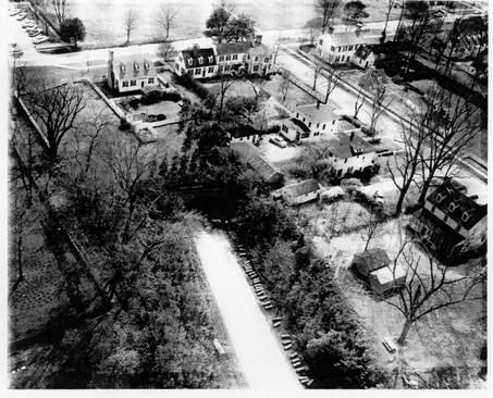 Photograph of Block 28 in 1956, showing Ludwell Tenement, Peyton Randolph House, and Archibald Blair House (background, left to right); Miller, Skillman, and Donegan Houses (foreground, top to bottom)
Informant Descriptions
Mr. James Bateman
Worked in the archaeology laboratory when located on the west side of Botetourt Street from about 1948 to 1950. Responsible for "reconstitution" of artifacts and assisting with museum exhibits. Interviewed February 11, 1983.
Mr. Neil Black
Miller at William Robertson's Windmill, which sits on Lot 4 and Lot to the north, on North England Street, since 1960. He was absent from 1964 to 1968. Recalls Millers and Skillmans, and particularly when their houses were torn down. Interviewed March 21, 1983.
Mr. and Mrs. Howard Brindle
Mrs. Brindle was raised near Carter's Grove, five miles east of Williamsburg. Mr. Brindle first came to Williamsburg in 1942 and started working for the Foundation in 1947. In a lottery held in the Landscape office, Mr. Brindle was chosen to tear down the Skillman house. He, his wife, their son, and an assistant spent just over a month in early 1963 to demolish the two-story dwelling and cart away the materials to rebuild their present home on Bay Shore Road near Jamestown, Virginia. Interviewed March 4, 1983.
Mr. Paul Buchanan
Draftsman in Architecture Department from 1949 to 1960. Then, Colonial Projects Designer in Architecture. Finally, Director of the Architectural Research Department from 1968 to 1980. He knew Mr. James Knight and visited the archaeological sites several times a week. Interviewed February 17, 1983.
Mr. Armond D. Campbell
Was Supervisor of Colonial Williamsburg Laundry from 1941 to 1980. Original Laundry was in the same warehouse as the archaeology laboratory. He lived in the Donegan duplex (lot 4) from May 1955 to August 1956. Interviewed February 14, 1983.
Mr. James Christian
Presently, Mr. Christian works in the Colonial Williamsburg Paint Shop. Between 1951 and 1957 he was a laborer on Mr. Knight's archaeology crew. He was one of the excavators on the various sites behind the Peyton Randolph house. Interviewed January 5, 1983.
Mrs. Angie Cowles
Office Manager of the Goodwin Building during the 1950s. She lived in Apartment A, south half of the Donegan duplex from January 1939 to February 1956. She resided there with her son, and his nurse, who left them about 1944.
Mrs. Cowles is now retired and living in Williamsburg. Interviewed January 19, 1983.
Mrs. Gertrude Daversa and Mrs. Virginia Lucas
Gertrude and Virginia Ball, respectively, grew up in the Peyton Randolph house (Lot 10). Their mother's mother, Mary Proctor Wilson, bought the house from Williamsburg Incorporated (not to be confused with Colonial Williamsburg, Incorporated) in 1921. It was their mother who first discovered the house they lived in was that built by Peyton Randolph (sic). Mrs. Ball spent years restoring the house. Mrs. Daversa now resides in the east wing, the main portion being opened for exhibition in 1968, seven years before her mother's death. Mrs. Lucas has made her home in New Mexico for about thirty years and is a frequent visitor to the residence she feels is her home, the Peyton Randolph House. Interviewed March 4, 1983.
Mrs. Carra Dillard
Grew up in the Archibald Blair House, formerly Van Garrett residence. Recalls the former neighborhood along North England Street. Mrs. Dillard gives a description of the windmill that pumped water on the Peyton Randolph property at the turn of the century. Interviewed March 18, 1983.
Mr. John ("Jack") Goodwin
Two or three summers between 1940 and 1943, was one of five or six on a crew of High School excavators. Excavated property on Francis Street. Charlie Gilliam was foreman one summer. Ernie Frank was in charge. Reverend Goodwin's son and T. Rutherfoord Goodwin's half-brother. Interviewed April 27, 1983.
Mr. Frank Jacobs
Mr. Jacobs is now Director of Building Maintenance at Colonial Williamsburg. In 1931, he lived in a bungalow with his parents behind the Archibald Blair House, across England Street from the Miller and Skillman former residences. He drove a service truck for Colonial Williamsburg during the 1950s and saw Mr. James Knight and his crew several times a week. Interviewed February 2, 1983.
Mr. Rufus Jones
In Colonial Williamsburg Landscaping since 1949. Some involvement with the Skillman and Miller properties. Interviewed March 21, 1983.
Mr. Edwin Kendrew
Was Director of the Architecture Department from 1930 to 1964 (see Timeline). During that time he was also Resident Architect, Vice President and Director of Construction and Maintenance. He retired as Sr. Vice President from Colonial Williamsburg in 1968. Interviewed March 16 and April 25, 1983.
Mr. James M. Knight
A draftsman for Colonial Williamsburg Architecture Department from 1937 to 1965. He was in charge of archaeological excavations until 1956 and was responsible for those behind the Peyton Randolph House north to the Windmill. Drafted maps and plans for the sites excavated. Now retired and living in Williamsburg. Interviewed December 9, 1982, and April 20, 1983.
Mr. Tom and Mrs. Leah (Miller) McCaskey
Mrs. McCaskey, her parents and sister moved into 225 North England Street about 1926. She lived there until her marriage to Tom in 1936. Mrs. McCaskey's mother resided there until her death in 1969. The house was demolished in 1972. Interviewed December 10, 1982.
Mr. and Mrs. John Selby
Lived in the Skillman House from August 1961 through November 1962. Soon after they moved in, the garage behind the house was torn down because of its dilapidated condition being a hazardous condition to their three small children. Interviewed April 28, 1983.
Mr. and Mrs. Aubrey Skillman
Mr. Skillman's father, W. C. Skillman, had the house built on Lot 7 in 1924. The family moved in 1925. Colonial Williamsburg bought the property in 1959, at which time they rented it out until its demolition in 1963. Interviewed March 4, 1983.
Mr. Minor Wine Thomas
First asked to assist T. Rutherford Goodwin in the archaeological lab in 1938 because of his chemistry background, which he received at William and Mary. From 1938 to 1942, he was Special Assistant for the Archaeological Museum. During those years he assisted in experiments and devised successful artifact preservation treatments, museum exhibits, and early lectures on Williamsburg archaeology. Mr. Thomas was on leave from 1942 until 1945. Upon his return he became Museum Assistant, switching to Director of Craft Programs in 1953. He left Colonial Williamsburg in 1956. Interviewed March 1, 1983.
Lot 4: Mrs. Angle Cowles, Apt. 1, January 1939 - February 1956
Mrs. C. When did I move into the Donegan house? Miss Castle was living across the street in the Donegan [house] and she was going to leave. That's when I moved over there. I had the side of the house down next to the… windmill. It was on the end not closest to the Peyton Randolph [house].
I remember one great big [tree], not very far from the edge of the tunnel. The tunnel that goes under Williamsburg. That was built while I was [living in the Donegan house].
It was a nice house, a nice apartment to bring up a child because it had a nice yard. The boys could play football out on the side of the house. They had a real good time playing out there. They had this lot that was next to it where they were excavating for the windmill at the time [1953].
It was a large, large house. The rooms were large and the ceilings were high. It had a nice living room, nice big living room. And no dining room. And a large kitchen. Then a back porch to each apartment that was screened in. It had two bedrooms upstairs. A bath, and one large bedroom on the third floor. That had dormer windows. You can imagine the looks of the house because there were two sides just like that. Each side was exactly alike.
Ms. F. Today would that third floor be considered an attic? Was there anything above the third floor?
Mrs. C. No. Nothing above it. But it had those little closets underneath those dormers. You had to bend over double to get into them. 'Course I remember getting all of my son's toys and things out of one of those closets.
[There was a fireplace] in the living room.
Ms. F. You had bats come down the chimney?
Mrs. C. Uhuh… I killed 40 bats in my house. Then they send down and gassed the chimney to be sure to get all the bats out. Then they put wire over it so they couldn't come in… C.W. [put wire over the chimney]. Ohh. But those bats almost drove us crazy for a little while there … It was in the summertime. Yes. I remember.
I had a broom that I kept handy. I had something to cover my hair [also]. You've always heard about them, getting into your hair. So, I had something to put over my hair. If I'd hear a bat I'd go.
The furnace was in the basement. It was a coal furnace.
[The garage] didn't have any doors. It had a little storage area to one side. That part was enclosed. It was just room for two cars. [The storage area] was made onto the garage. They couldn't have put that on the side when we were living in the Historic Area. So, you see, that was very nice. When the Tuckers moved in, Mr. Tucker put the [basketball] hoop on a pole.
Ms. F. Did you enjoy living in that house?
Mrs. C. Yes. I did. It was on the fringes of the restoration and yet we could do things there that you couldn't have done [if you lived in the Historic Area]. For instance, the boys couldn't have played football in the backyard of any of those other houses. They used to go up and play on the Courthouse Green.
I can't remember what all was [in the yard]. But I remember when we all had to have Victory Gardens [1942]. We had a little one out there. It was in the duplex yard back there where the windmill is. We just had it that one year … . It was back from the street, not quite at the edge of the tunnel. It was when the war was going on and everybody was asked to have a garden. We just had a small garden. Lettuce… .
The front yard had a walk down the center. I guess it must have been brick, but I don't remember. I don't think the front yard was ever used very much. I don't think it had shrubbery, which made it a bare sort of looking place. We had flowers round the back. I used to have a bed of flowers in front of the screened porch.
Ms. F. Who else lived in the duplex?
Mrs. C. Mr. Campbell, who worked in the Architectural Department. They were there when we moved in. They had a son. The Pilands lived there for a while. Raymond Piland. They had a son. Several people lived there while I did. Ohh. The Tuckers. The father was Pete Tucker [who] worked for Colonial Williamsburg. And they had a son who was Pete also. Mr. [Armond] Campbell was in charge of the Colonial Williamsburg Laundry. They lived there. There were a good many families who lived on the other side of the duplex.
Ms. F. You mentioned the Campbell who was the architect, Raymond Piland, and Pete Tucker. Do you remember any other names?
Mrs. C. The Langtons. L - A - N - G - T - 0 - N. In the Accounting Department. That just about does it… Mr. Langton died there.
Ms. F. Really. He died in the house?
Mrs. C. Mhm.
Ms. F. Did you know the Donegans.?
Mrs. C. No. I didn't have any idea who they were.
The Millers were still living where they were [Lot 5 and 6]. I think the Skillmans still lived there [Lot 7]. They owned the house back of the Peyton Randolph [house] and the Millers. The Millers had a little cottage out in their years. [They] were mighty good neighbors. We enjoyed them. So were the Skillmans. We didn't see too much of them. You know, in those days you just didn't have much time.
Ms. F. Do you remember what year you moved out of the house?
Mrs. C. I was told while I was living at the Donegan house that it would be a good idea to keep my eyes open because they were going to build the windmill on that spot. When the Greenhow Kitchen became vacant [I moved there]. That's behind the spinning and weaving shop [former]. I lived there for the last 11 years [before retiring] on the second day of January 19 and 67.
Ms. F. So, you lived in the duplex from sometime in the late 1930s [1938] to 1956.
Mrs. C. The Donegan house was taken down. Someone bought it I think. It was my understanding they bought it, marked the pieces and built it somewhere else … . But I don't know. It was a nicely planned house.
Ms. F. I thought I had read something about it being demolished…
Mrs. C. Well, maybe it was. I just vaguely remember somebody saying that someone bought it and moved it. Of course, they had to tear it down to move it.
Lot 4: Mr. Armond D. Campbell, Apt. B, May 1955 - August 1956
Mr. C. May 1955 to August 1956
Ms. F. How did you come to be in the Donegan house?
Mr. C. I left Williamsburg in '43 and came back in '44, out of the Service. When I came back John Gree, who was Vice President and General Manager for the hotels and restaurants, put me in the little cottage on Tazewell Street. I believe they sold that property to Dr. Clarence Hall. I had to get out of there and they let me have a part of the Donegan house (apartment].
The biggest thing that I can remember about that house, well, I didn't have any maintenance on the yard. It was kept up by C. W. When you walked up to the front entrance it looked to me like they had taken the house and cut it right smack in two and partitioned it off. There was a door on the right hand side [after you went through the front entrance] and a door on the left hand side.
As you go in the door there was a living room with great big tall windows and a fireplace in the downstairs. The next room back was the kitchen. And then in the summertime the whole length of the kitchen area on the back was a porch. A nice screened-in porch.
I can't remember whether there [were] two or three bedrooms. There must have been three bedrooms. There [were] two on the second floor and one on the third floor. At that time I had three children. I had two girls, and a boy. The oldest girl's name was Joan. The other girl was named Barbara and the boy's name was Armond. There were five of us.
I hated like heck to move from there. Rent was cheap. I had no maintenance. As near as I remember, I only paid $35.00 a month for that apartment. I remember getting along with Angie Cowles … . It sticks in my mind that we had a central heating system and a sharing plan with the oil and all. We enjoyed it there. We were restricted to some degree. Your activities, what you could do in the Restored Area, but it didn't bother us.
Other than Mrs. Cowles we never knew or associated with anybody else over these that I can remember. At that time, in 1955, I was 40 years old. We were playing hard. We were fishing, hunting, all that in our spare time. The children played around the neighborhood. There was a family directly across the street that had some children. I can't remember who they were. I remember the children playing around there. I had no trouble with mine getting down on the Park Service.
Ms. F. What do you remember about your yard?
Mr. C. It was flat and green and well-kept. I remember these two sheds [in photo] out here behind the house. [One] could be used for a garage. At that time I didn't have an automobile. I can't remember what exactly was in there.
Now that you mention it, [Mrs. Cowles's son] was away at college. There wasn't anyone there but Angie. My son was born in '43. He would have been 12 years old. That brings back old memories … At that time, as I say, I was very active fishin', and huntin'. The York River was full of fish and the woods were full of game. My cousin and I salted a great big ol' beef hide. I can't even remember whatever happened with that thing. But we were just foolin' with that thing. We had a ton of salt on it, I know that!
Ms. F. When you were living in the Donegan house was the garbage taken away or did you dump it someplace?
Mr. C. No. The garbage was taken away. It was picked up by the town. I remember putting the garbage out front, the cans out front.
Ms. F. Do you remember when the house was taken down?
Mr. C. Well, I should. Really, I can't remember much about it. I just lost all interest in the site when I left there. It wasn't on my way home, back and forth to work.
Ms. F. Is there anything I haven't asked that you remember about the neighborhood?
Mr. C. No. You see, we had our own little crowd of people that we went around with. And actually, due to the fact that I lived in the Restored Area, most of our activities were out of the area. Because of the confinement. but, we enjoyed very much living there.
Ms. F. Do you remember what some of those restrictions were? Were they written down?
Mr. C. No. They were just taken for granted. You were just on your good behavior when you were in the Restored Area. I guess with original and life time tenants, it's a little different. But for an outsider to come in, like I was, you pretty well played according to their rules. Just plainly understood.
Lot 4: Mr. Frank Jacobs
Mr. J. From there we went to Miss Van Garrett's bungalow (behind the Archibald Blair House]. Approximately 1931, for about a year. It was a one story, three room bungalow with a little small porch on front with a board fence across the front.
The person I can remember who lived in the Donegan house while I was living [in the bungalow], was "Bennie" Meisel, who was the Town Manager, City Manager. Bennie, B-E-N-N-I-E Meisel. I always called him Bennie Meisel. [A. L. was in the records]. I can only remember him having one daughter and she was killed in an automobile wreck coming back from Richmond one time. . I think I had moved from the area. I was living on South England Street when that happened.
Mr. Pete Tucker lived there one time, same time Angie Cowles lived there. Floyd Tucker. We called him Pete. The Langton boys, I used to pal around with those, two of them. But at that time I was living over on Capitol Landing Road … . We went to school together. It was Charles and Jack Langton. And there father, Mr. Langton, worked in the Accounting Department, I believe. He died of a heart attack and then they went back to New York where they came from.
Mr. Minor Wine Thomas
Okay. I knew George Small, slightly. He was a professor at the college. I knew of Mr. Meisel, city manager. I knew G. T. Brooks, although he didn't live in (the Donegan house) at the time. I knew him later years after he'd moved out of that house. Oh. Wanda Castle and Miss Croxton. Wanda became personnel manager of CW's secretaries. I haven't thought of them for years … When I was a kid my grandfather ran a dairy farm, and in the summertime I used to take over the milk delivery route. So, I knew the back door of practically every house in Williamsburg. I remember Miss Castle and Miss Croxton simply as people I delivered milk to. Angie Cowles and her son, I knew.
Oh. I see, this is the other half of that house (timeline) … Wash Reed I knew. He was with the Architectural Department with CW … George Campbell was a CW architect I knew slightly. Raymond Piland, I remember simply as a name I delivered milk to. Armond Campbell was the fellow who used to run the CW Laundry.
CHAPTER 4
In Chapter 4 the informants discuss what they recall about Jimmy Knight and his crews during excavation activities around their properties. Lots Four, Five, Six and Seven were excavated between 1955 and 1956 (Lot Four after August 1955). Mr. Moreau Chambers then collated an artifact analysis from the material saved during those excavations (analysis dated April 1956). In 1938, the east wing of the Peyton Randolph house was uncovered in excavations. At the same time, part of the backyard was cross-trenched. Excavations of Lot 10 were completed in 1940 during which time the house was being renovated. In 1978, part of Structure A on Lot Five was excavated, and a larger strip on that property was dug from July to December of 1982. Work has continued southward onto Lots Six, Seven and Ten since then.
Lot 4: Armond D. Campbell
Ms. F. Do you remember Jimmy Knight around at all?
Mr. C. Mhm.
Ms. F. What do you remember about him?
Mr. C. Well, the only think I remember about Jimmy Knight —- Jimmy was awful quiet. He was awful business like. Slow. Easy going person. I never did have much personal contact with Jimmy. I knew him well enough to speak to him.
Ms. F. Do you remember much about the excavations around your property? Or area? When they did the cross-trenching…
Mr. C. Now that you say it, yes. I was there when they were doing some cross-trenching. To an ordinary person it looks just like a bunch of foolishness. So, that's what it looked to me in those days. I didn't have too much of an interest.
Lot 4: Angie Cowles
Mrs. C. I don't remember anything about [the excavations], except that they would come and I would see them in the morning as I was going to work. They would be working down there that day, I suppose. They must have worked all day. I knew they were excavating for the windmill [1953] because they told me I should be on the lookout for another place. They were going to build the windmill on that site…
Ms. F. Did they excavate around the Miller and Skillman houses while you were there?
Mrs. C. Not while I was living down there… I was living there when they were excavating that lot on the left (for the windmill).
The only excavations I saw going on were over there in that spare lot to the left of our apartment. If I am standing at the front of the house, it's on the left.
Every now and then they would appear and they were going to excavate over there. We had a little cocker spaniel I got for my son when he was six. And she lived until he was sixteen. We just loved her dearly. She died during the night. My son buried her out at the edge of the tunnel. He was the excavating me over there and he said, "Please go there and tell the men excavating not to dig up Blackberry's grave." He had put a piece of slate over it. They said, "We're not going to." I'm sure Blackberry's grave was dug up [with the tunnel]. We didn't know … . She was a sweet little dog. We just loved her.
Lots 5 and 6: Tom and Leah McCaskey
Mrs. M. I don't think [the front yard was excavated]. The excavations went right up to the big hedge that divided our house from the Skillmans. They went right up to the edges there and did not go over. Mrs. Skillman, I don't think, would let them do it.
[The excavations were] after Tom and I were married. He remembers too. He was the one who persuade mother to do it. He was working for Colonial Williamsburg. They asked him to ask her [if they could cross-trench]. But they didn't go very deep. They were diagonal. I just remember Jimmy being around with his crew.
Mr. M. They dug about eight inches around the foundations and left them for several weeks, took photographs, and filled them up again and that was it. It was private property they were working on. They did a good job fillin' and packin' it. That whole area your mother used for her parking.
Mrs. M. Yeah. It sunk and they would come back and fill it in … . Every time it would rain.
Mr. M. You should have a lot of gravel down there.
Mrs. M. Different kinds of gravel.
Mr. M. They used all kinds of gravel.
Mrs. M. It was muddy and then they brought the red clay to put in where the parking lot was.
Mr. M. Enough to drive any archaeologist crazy.
Mrs. M. You know the round thing that they think was the still? It was under the big trees, exactly where you are digging now [in December 1982].
Mr. M. It was a round brick foundation.
Mrs. M. They thought it was a still. I had a picture of that and the main artifacts —- the ones that were valuable.
Mr. M. They were in the archaeological library at one time. These copies were made from those pictures. I've got some out in the yard in a couple of boxes.
Mrs. M. Mother was so mad. They dug these trenches right up to the basement. Those trenches filled with water and all the water poured in the basement. And the foundations of the house shifted. The house was all about to fall in. Mother had to have big wedges put in there to hold the house up.
Mr. M. Cost us a lot of money to shore the house up.
Mrs. M. Anyway, mother was upset and called them up and said the artifacts belonged to her and she wanted them back. They told her that anything they dug up she could have. Ed Kendrew called and said there were several very valuable finds. Could he keep them? I think they were some coach buckles, and some Indian pottery. She said, "Yes. The valuable things." So, this other stuff, they brought and put in the garage. Mother, when her tourists came… were allowed to go out and pick out what they want and take away. When the house was destroyed all that stuff was there. We just brought it along.
Mr. M. Two boxes of it. If you'd like to take it away, you're welcome to it.
Mrs. M. We don't want it. Tom said, "Someday somebody will be interested in it." So, we kept those. They're just bottles. Broken bottles.
Mr. M. Iron, bottles and ceramic.
Ms. Foster then produced some artifacts excavated from Lot Five.
Mrs. M. (Shown a marble). We all played marbles. That doesn't look like a very modern one. It looks like it's kind of opaque.
Mr. M. You mean you used to shoot marbles with the boys?
Mrs. M. Well, they were pretty!! I don't remember playing marbles. There were cousins comin' and goin'… boys and everything. It wouldn't have been mine. I remember playing jacks—Daddy teaching us how to play jacks.
Ms. F. We found that just under the sod.
Mrs. M. The Smalls lived over there. And the Campbells. They all had sons. Mr. and Mrs. Campbell had a son. The Smalls had one or two boys when they lived in that house… I don't remember any girls. Everyone over there had boys. That's where the windmill is—the duplex.
(Shown two pieces of linoleum). That's a very modern piece of linoleum. I think Mother had that in the little pantry she turned into a bathroom. This was in the kitchen. There was a big pantry, when Dad couldn't go up and down stairs and she had a toilet put in there.
Mr. M. That's where all the canned stuff was. And what a pantry! … It looks like stone.
Mrs. M. This was called congoleum. It was in the kitchen. Of course about [every] five years it would get dingy and everything. Mother would put another coat on top of it. I think that was the last one she had on there because mother loved the color on that. They didn't have that shine on it that they have now. You'd have to get down and scrub it.
Mrs. M. (Shown green globular stuff). The house was old and although we pumped stuff in the walls to keep it warm, we used lots of putty to go around. I don't remember it being green.
(Shown a fragment of a doll's head). My sister and I had dolls all over the place. I'm sure we had battles and smashes with them. I don't think it would have come from across the way because there were all boys over there.
Mr. M. That would have been a pretty small doll.
Mrs. M. We had lots of dolls. All sizes because mother loved dolls. If I wanted a bicycle, I got a doll. If I wanted roller skates, I got a doll. Mother just loved dolls. She sewed so well, she'd make the cutest outfits.
Mr. M. It looks like pretty good porcelain. There are the eyebrows —- French eyebrows.
Mrs. M. (Shown a piece of glass). That's a lump on there. Oh, that's glassware that has lumps on it. Mother loved red glass.
Mr. M. This has got knots on it as though it was a bowl. But it had to be an awfully thin bowl.
Mrs. M. She had glasses. Every time we went to the Pottery she'd bring more red glass back. She did have a lot of red glass. I don't think it would be over that far [Lot Five].
Lot 7: Mr. and Mrs. Aubrey Skillman
Ms. F. Were you [living] in the house when they did the archaeology in the front?
Mr. S. No. We were living up on Richmond Road.
Ms. F. You mentioned a well.
Mr. S. The Restoration sent us some pictures.
Mrs. S. It's a round well in the front yard. To the left.
Mr. S. Jimmy Knight told me, I forgot what, I could get $100.00 a brick or something for the house. He said, "I can tell you how many bricks are in there."
Mrs. S. … sell those bricks to the tourists walking by.
Mr. Frank Jacobs
Ms. F. You said you remember Jimmy Knight. Do you remember seeing him in any particular place?
Mr. J. Every day… . I was working here when Jimmy Knight was here.
Ms. F. Did you go out to the site everyday?
Mr. J. Oh, no. But I mean going by it. I worked a service truck here for years. I would see him at least two or three times a week.
Ms. F. What to you remember seeing Jimmy Knight and his crew doing?
Mr. J. Cross-trenching. That's all they ever did. And screening. They'd cross-trench and screen it.
Ms. F. Do you remember what those screens looked like?
Mr. J. The screens? Just a wooden frame with some quarter or three-eighths inch mesh wired on the back side with two legs coming down. They'd take the shovel, throw it up there and it would roll back down to the bottom and sift on through … . What they wanted to save was in the bottom of the box. They kept raising it up and make a higher pile. I thought you all still used those.
Ms. F. No. We use different ones. Ours are on a horse. Actually the horse would be over my head. There are chains coming down which are at each corner.
Mr. J. You all shake yours.
Ms. F. We shake it and the pile builds up and we have to shovel it out.
Do you remember any of the excavations around the Peyton Randolph house?
Mr. J. Only the cross-trenchings. That's all… Seeing pieces of foundation. I remember they dug in front of these two houses [Miller and Skillan] before they tore the houses down, before they brought the property I think. I think they got permission to dig. That's when Mr. Skillman was still living… They did find foundations.
Jimmy Knight
Mr. K. After World War II, we did the one down here in the front —- the Miller and Skillman houses (1955).
[The Donegan] was a two-family, double house—duplex.… . That's not even on the Waddill Map. I think that was built about the time of the Restoration [1929] .
… back of the house where Mrs. Ball lived —- that was before World War II [1938 to 1940]. We didn't cover that the same year we did the Miller and Skillman houses. That came several years later [1955].
(Lots Five and Six). We were out here after World War II. Here are the two trees … . That's where you all are digging right up close to the trees [1982] We kinda stayed clear of the trees on account we were afraid we'd damage them. One time I ran into a root and I called a Landscape man so he could paint them with asphalt or tar.
I think you two girls [Ms. Foster and Ms. Derry] are standing where I dug. Here. (Miller and Skillman lots). We all dug under where they were. I remember when we were digging over there [the] people were living in the houses. [We dug] up to the shrubbery.
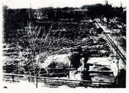 Photograph of Cross-Trenching on Northeastern Side of Block 14
Mr. James Christian
Ms. Derry. How deep did You dig?
Mr. C. Well, sometimes three feet down. 'Til we find the foundations. See, we did trench across… side by side. One trench and then another trench. We did 'til we find, hit a building or something. Then we go down and trace it on out. We trace it on until we get to the end of it. Then when we get to the end of it, then we curve around the building, until we find the whole thing.
Some buildings we find a fireplace to it. An old kind of fireplace. We'd get down on our knees. We'd use a pick and a shovel and get all the dirt and stuff around there. Then you take a whisk broom and sweep the stuff over and clean it right on out. You could tell if it old chimney if it burnt. Lot of burnt ash.
(Referring to Skillman site). We dug across the driveway… It was hard work. There was a garage back there… It was hot. That driveway was hard as brick. Yeah [we skipped over the bushes]. We dug all them trenches. Then we covered them back up.
Mr. Minor Wine Thomas
Ms. F. When you started, about '38 or '39, they were working on the east wing excavations at the Peyton Randolph house. Do you remember anything about that?
Mr. T. No. For about the first year that I was working, I was working only part-time. I was going to school. Really, my only contacts were with the laboratory. I got out in the field to see Jimmy Knight very infrequently. In later years I saw a great deal more of the fieldwork.
Ms. F. Do you remember much about the Peyton Randolph house in its early days? You mentioned you knew Mrs. Ball.
Mr. T. My recollections of Peyton Randolph are mostly as a rather dilapidated old house that this funny old woman lived in. When I say funny old woman, I was a kid at that point. I guess anyone who was 35 would be an old woman to me … . She was very interesting really. She was one of these people who could talk a blue streak. She would let you know that she was just a little better than you were without being obnoxious about it … . She always pretended she didn't like the Restoration very well, but I think actually she did.
Lots 5 and 6: . Mr. and Mrs. Tom and Leah (Miller) McCaskey, 1926 to present
Mrs. M. We used to have beautiful pecans there. The trees are old now and not good. You'd look out in the morning and there would be 12 or 15 colored boys picking up pecans. People would swarm over there for pecans, especially after a wind.
The first Mrs. Warburton, who lives in Williamsburg, says that her in-laws lived in the Peyton Randolph house in the, late 1800s, and that her mother-in-law or her mother planted the trees in 1864. It was wartime when she plated those trees there. Mrs. John Warburton. She would be a good one to talk to. Her husband lived there. It was her husband's family. I think she was the one who told mother. Mother was always so proud of those pecan trees. But she was scared of them and she had lightning rods installed up in them.
Mr. M. C. W. put [the lighting rods] up for her and didn't charge her.
Ms. F. Did you ever have a garden on the lot?
Mrs. M. It never was. I don't ever remember anything being on that property. That was always open. Mother couldn't get anything to grow on it. When it was excavated we found it was wall to wall brick paving.
Since 1926 there was nothing on that property. Sure [we played there], and until they built the duplex, we played all on that side too.
Mr. Minor Wine Thomas
Mr. T. I knew the Millers. Leah Miller. She used to take tickets at the Williamsburg Theatre when Tom McCaskey first ran it. Finally he married her. She was a beautiful girl too.
Mr. Frank Jacobs
Ms. F. Did you ever hear any stories about the old pecan trees?
Mr. J. Yup. They had good pecans on them, I can tell you that. I ate my share of them. I think I had to sneak over and get them. I am not quite sure.
Mrs. Carra Dillard
Ms. F. Did the Warburtons plant the pecan trees?
Mrs. D. No. Those pecan trees were supposed to come from Monticello. In our yard [Archibald Blair House], in their yard, and in the Tucker House's yard. Just recently have they stopped bearing fruit. I mean the old Archibald Blair, the Van Garrett House, have borne up until recently. When I left the house, that is, after Mother's death, they were still bearing. I asked Mrs. Healy who is living over there now, and she said that there were very few pecans left and practically what was there the squirrels ate. But, at one time there must have been about five or six [trees].
What I understand, I'm not sure if this is true, was that Judge Tucker, who lived in the Tucker House, had gotten these from Monticello and that he gave one, one or two, to Mr. Thompson or whoever was living in our house at the time, and to whoever was living in the Peyton Randolph House. And then of course, a lot of them, because father used to plant the young trees, so we had eight. They bore perfectly beautifully.
[They] were great big trees when I was a little girl… Judge Tucker must have planted them in the very early 1800s. The young trees that grew from those original ones were planted when I was a child, but not the originals. There were two or three of them that were planted very, very early and they were the old ones.
Ms. F. Do you think the ones in the Peyton Randolph—-
Mrs. D. I think they were very old trees.
Ms. F. They would have been some of the originals?
Mrs. D. I think they were. Yes.
One of the exciting times of the year was you'd get somebody to come and, what we call "thrash the trees". I guess thresh was really what they were saying. These young colored boys would climb the trees with great long poles and they would get up there and beat these branches. We just had bushels of nuts. And it was just more fun. Of course, they couldn't get 'em all, 'cause they couldn't go up to the top so the wind would blow them. Our favorite occupation as children was going out in the yard in the fall and finding pecans. They were beautiful pecans.
Mr. Nell Black, miller at Robertson's Windmill
Ms. F. Do you know anything about the area before you started here as a Miller? Linda Derry is trying to figure out what went on in our yard [excavated 1982].
Mr. B. That was a garden. They used to dig it up by hand, the mother and daughter. They dug it up by hand and they were always planting something [tenants of cottage]. Then, down the fence this way [east] just a little bit, towards North England Street, Mrs. Miller would dig up a little area in there for her garden. She planted tomatoes and things like that.
Mrs. Miller was a nice person. She would come and hang over the fence [while we] were opening the sails. And after we opened the sails we went over and talked to her. She could tell you a lot about how they got the place to where it was, and about growing a garden…
Ms. F. Just like we used to hang over the fence.
Mr. and Mrs. Aubrey Skillman
Mr. S. Those old big old pecan trees over there.
Ms. F. Did you visit those pecan trees very often?
Mr. S. Oh yeah.
Mrs. Carra Dillard
Mrs. D. Mr. Ed Warburton was the mayor of Williamsburg… They were a very nice family. His wife was killed by a cow. She was milking the cow in her backyard and the cow gored her and she died from the wounds, so that the Warburton children, there were four of them, John was about my age [Sara Warburton's husband], were brought up by his sister. Miss Lettie Warburton came in.
They had that great big old yard with pecan trees and they were one of the few families in Williamsburg that had a bathroom, because there was no water system in Williamsburg. But they had an old windmill. One of those awful old windmills that made more noise … . [The windmill] pumped the water up. I don't know much about mechanics, so I don't know exactly how to explain it. Anyhow, when the wind blew, this thing went around and pumped the water into a tank and then you can have a bathroom.
Later on I think the people down at Bassett Hall had a bathroom, but mighty few people in those days had bathrooms because there wasn't any water. There wasn't any way we could have water in [the Van Garrett/Archibald Blair house] until Williamsburg put in water.
Lot 6: Mr. and Mrs. Tom and Leah (Miller) McCaskey, 1925 - present
Mrs. M. Mother bought the house in 1925. Mr. Swingle built two houses, alike. Side by side. And he lived in one which the Skillmans lived in. And Mother and Dad bought the other one.
Mr. M. Both of those were on the Peyton Randolph property.
Mrs. M. I think we moved-in in January 1926. I lived there until Tom and I married in '36. And my mother and dad lived there until he died. Mother died in '73 or '74. Anyway, I kept the house for a couple of years and rented it out until we ended an agreement with Colonial Williamsburg. They rented for fifty years and then they have the right to buy.
The tunnel was not there in those days. Dad's property ran all the way back.
Mr. M. Into the warehouse area. It was a very large garden. Maintenance area's of CWF now there.
Mrs. M. Dad had a large orchard. A big garden there.
Mr. M. The best white corn [grew there].
Mrs. M. He had apples and peaches and pears. There were beautiful trees in there. Very rich land. There was a stream back of Miss Kelly's.
And then one day we were awakened by the sound of saws and machinery. And Dad went out in the back and there was men cutting down his trees. Big bulldozers, around, there.
Mr. M. Park Service personnel.
Mrs. M.
And they said, "We're putting a tunnel through here." Nobody ever told Daddy or asked him or anything. And they took over half his property. He took it
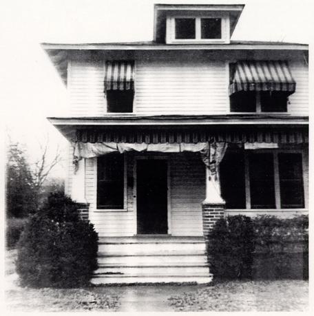 Photograph of Miller House
to court and it stayed in for years and years and finally paid Dad $2500.00 for it. He never got over it.
Mr. M. There were two lots there. They went way back. Nobody was worried much about how far back they went.
Mrs. M. [Mother] ran a tourist home. When the bank failed… all they had left was the house. That was just before I started college, I think. It was the second go around, '31, when they lost [everything].
[The house] had a basement. The basement floor was concrete. But the walls on the side were just dirt. And all those brick foundations—-
Mr. M. Foundations were protruding on all sides.
Mrs. M. You could see the old foundations bricks running into where the basement was.
Mr. M. You'll find the area where the house was excavated below those. They'd destroyed the foundations in there. It went down three or four feet below the foundations.
Mrs. M. [The house was a one family house]. I had a sister, mother and dad.
Mr. M. [The house] had five bedrooms.
Mrs. M. It was a big house. It was a very tall house. When they destroyed the house, they just bulldozed it into the basement… It wasn't a huge basement.
Mr. M. I would say the size of the basement was 15 by 20. Twenty feet wide and 15 feet deep.
Mrs. M. There was also, back of Mother's house, a small [structure]. There was no foundation, so that the cabin in the back wouldn't have been of interest.
Mr. M. It was put on blocks.
Mrs. M. There was an old schoolhouse on the other side of the Peyton Randolph House. A brick schoolhouse. And back of that was what they call a hunting cabin. I don't know why they called it a hunting cabin. No, I guess it was back of Ed Spencer's, which was right next to that. Daddy bought the little house and brought it over and put it on the property, added a bathroom and kitchenette, and rented it out. The Bursar from Bruton Parish lived in it for 10 or 15 years.
Mr. M. It, was a two-room cottage with bath. There was no digging. It was just pipes n the ground. It was sitting on cinder blocks.
Mrs. M. There was plumbing and stuff like that. Then there was a double garage and a wood house to the right of that. They tunnelled right up to the back of the wood house [in building the tunnel]. There was no dirt left in back. It was that close.
Mr. M. It was sloped.
Mrs. M. In 1926, shortly after Mother bought the house, I've forgotten when the Balls bought the Peyton Randolph house, there were two buildings standing [on the Ball's property]. I faintly remember one. One was filled with old furniture- chairs, tables, and a beautiful chest of drawers that only had three legs. Some men were burning all the furniture. As Dad came by there were throwing this chest [in their dining room] on it. [Dad] needed a place to keep his tools and so he gave them $5.00 and they took it over and put it in the garage.
For years and years and years it was in the garage with his tools. When Daddy died, there was a Mr. Greenwood that rented Mother's cabin. His hobby was restoring furniture. He asked Mother if he could take that piece of furniture and restore it. Which he did. All the brass is original. He too the three legs and he cut a piece off of each one and made a fourth leg … . It was beautiful. He had John Graham, who was the curator, to come over and look at it. John dated it 1860s [when the Warburtons lived in the Peyton Randolph house]. Mr. Greenwood kept it in the cabin. One day he dashed in with his suitcase and told Mother he was leaving town … . He said, "anything in the cabin is yours." Mother moved that [chest] inside. When she died it was one of the few things I kept of hers.
[My sister and I,] Aubrey Skillman, the Garrett children on the corner, would play ball. We tried to play tennis but none of us were very good at it… The road was not paved out front for a long time. That's when that casket was found. So there must have been a cemetery where they put in that road. We played hide and seek and stuff like that.
The big tree in front of the old courthouse by the Lodge, that big magnolia tree was in front of Mother's house.
Mr. M. There is a restored building on the corner of Francis and South England. Just about 100 yards to the right there is another restored house. In between them is a huge magnolia. That was in our front yard.
Mrs. M. It wasn't that big then. It got too big at Mother's. C.W. was looking for a magnolia to go over at the new courthouse. She gave it to them. They came and got it. There is going to be a big hole in the front yard where that big tree was taken out.
Mr. M. It might be five foot in diameter.
Mrs. M. They took a lot of dirt with it.
Mr. M. It was in the middle of the front yard.
Mr. M. When they talked about the front yard, they meant that piece on the lot immediately in front of the house. That house took up just about all the lot in width.
Mrs. M. I think it was 20 by 60.
Mr. M. You had a driveway on one side, but the line came right close to the house on the other.
Mrs. M. Mother bought the second lot [5] later. Someone was going to buy the lot under the trees for a funeral lot. So, mother bought that lot.
There were two garages. The Skillman's garage came practically up next to Daddy's.
Mr. M. There was just about two feet between them. You could barely walk through there to the garden.
Mrs. M. Daddy had a vegetable garden. He particularly like white corn [and] grew cucumbers, onions, tomatoes, and radishes. His original garden was where the mouth of the tunnel is. It ran along a space back there … . He used cow manure [for fertilization]. A man used to come in a wagon who plowed it with a horse and spread the manure.
The box bushes are tiny [in the photo, front yard]. Now they are three or four feet. These are English box which grow very slowly. We moved most of them up here because that was mother's wish. There was one entwined in the roots of that tree. The maple tree that's there. And also a yucca plant… We knew we'd kill it if we tried [to move it], so we left it. What was right on the right side of the walk that went up to the front steps that you see in the picture. That will show you where the walk is.
Mr. Neil Black
Mr. B. Do you remember me telling you where the walkway was? And the box bushes? See the box bushes right here [photo]? Those are the box bushes that were there now … . The walkway wasn't right next to this. That was separate and the walkway went up to the front door. And there were awnings on the front of the house.
(Still looking at the photo) The little garage setting by the tunnel … . always called it a little garage. [The Millers] made a little apartment out of it.
Ms. F. do you remember anybody who lived there?
Mr. B. I don't remember their name… but, they were out of North Carolina… The mother was working at Eastern State, and the daughter stayed home. This was 'round about 1960, '62. I left about '64 and they were still here. When I came back [l968], they were gone.
It Was low to the ground. If you went in, you stepped about a foot high and you walked in. It wasn't built up like some of these two room houses today.
Ms. F. You remembered the Miller house being torn down. Right? And a Mr. Waltrip…
Mr. B. Waltrip… I've forgotten whether it was topsoil or gravel they put on it. He kind of smoothed it off and then he put some dirt over top of it. He didn't have to fill in much... Branscome [hauled in the gravel fill].
They tore this old house down before they tore the big house down [shed in back]. I remember Landscape was in this end of the building and asked some of those guys about helping them tear it down. It was nothing but just boards with a dirt floor in it. It was probably a car garage at one time.
Ms. F. How did they take the house down?
Mr. B. Bulldozer.
Ms. F. They just rammed a bulldozer into it?
Mr. B. Yeah. Then loaded it on the trucks and hauled it away. They had trucks settin' out here. Old big dump trucks. They ran into the side of it and rocked it a few times and it wasn't long before she was caving in. They scooped it up with these big buckets, loaded it on the truck and they hauled it off. I don't know, probably to the dump.
Ms. F. Then they brought in the rest of the [dump trucks] full of dirt.
Mr. B. And just filled in the low areas.
Ms. F. There wasn't much dirt brought in? So, it probably didn't take all day then.
Mr. B. Well, it took them all day to tear it down and haul it off. Then he left his equipment there. They did it on a Saturday … . They didn't work on Sunday.
The reason I know they took it down on a Saturday, because Landscape Department was in this building [stables across from the Windmill] at the time. I went over there that Saturday after the house had been torn down. There was a[n] electric wire laying on the ground. I looked at it as I passed by.
Monday morning the fella who was in charge of Landscape at the time, Homer Purcell, he is deceased, told me he walked by the electric wire and started to pick it up and he didn't pick it up. That was 'round about 8:30 and his men were going to work. About 10:00, VEPCO came. Come to find out, they had torn the house down and never turned the power off. Nobody got killed … . I don't know who called VEPCO, but [they] finally got a whiff that the house was torn down and they came down. When they got here they found out that wire was still hot. Just laying on the ground. It was an underground current then. The end came up out of the ground over beside the house. Could easily be put to sleep.
Mr. Frank Jacobs
Mr. J. I remember some fruit trees in [Mr. Miller's] backyard, but I can't remember an orchard. I remember a little small garden he had back there.
Lot 7: Mr. and Mrs. Aubrey Skillman, 1925 to 1959
Mrs. S. This was a very small town. Four or five hundred people. Mrs. Miller was a telephone operator.
Ms. F. Where was the telephone office?
Mr. S. It set up here on Francis Street. The little Penniman Building, at the time, by the Powder Horn.
Ms. F. What did the Powder Horn look like?
Mr. S. Terrible. Like everything else in Williamsburg. You've seen enough of the pictures. It was failing apart, just like all the houses —- like this Peyton Randolph house. It was pitiful. Nobody had any money. Nobody had anything.
Mrs. S. The college wasn't very big. You fished, I guess. His daddy was a commercial fisherman and would catch them on the boat. He used to haul ammunition from the Naval Weapons station. There was nothing for people to do.
Ms. F. Just a sleepy little town…
Ms. S. Dr. Stryker. I wish he were living. You'd enjoy him. He was the mayor here for years.
Mr. S. "Five hundred crazy livin' off of 500 crazy," [Dr. Stryker].
You had a couple of grocery stores here. Mr. Hitchens and Dick Mahone's. They would charge to people and maybe some people would pay every month. Some every six months. Some every year. If they had a good crop, or if business was good, they'd pay 'em off. If it didn't, they'd carry them another year.
It was a very small, narrow lot. But it was deep. I think it was only a 40 foot lot.
Ms. F. Forty by 140 feet is the average that I have. I wouldn't think that included the property behind.
Mr. S. No. That was almost as much behind there as it was [in front].
We moved there in 1925… My daddy had the contractors build the house. Two brothers named Rustid build the house. They lived up in Norge, Virginia. They started building it in 1924… Rift grain pine, which you can't buy today if you've got the money. The whole house was finished in natural pine.
It was one of the first few in 1924 that had a furnace in it and a bathroom inside. It had four bedrooms, living room, dining room, kitchen, sunporch, with a bay window.
Mr. Rockefeller came in person with Mr. Chorley to try to persuade Daddy to sell the property to C. W. They never would sell.
Ms. F. Your dad was a commercial fisherman. Is that right? There is a picture in that group… I finally decided that they may have been some of your dad's nets… in the back yard.
Mr. S. No. Now, they're turtle pots. Mhm… . If you come back sometime, I'll show you a picture of him when he was written up in the Washington newspaper.
Mrs. S. The Washington Sun.
Ms. F. August 14, 1955.
Mr. S. He'd catch turtles in the summertime. He fished in the York River and James River both.
There was a double garage and the little house that you see in that picture. That was moved in there prior to World War II. It was a little cottage that had been an office building at Jamestown. Mr. Bozarth was hauling rock in for the wall around Jamestown Island and it was going to be done away with.
[My father] brought it in, more or less, to use for storage, and wound up making it into an apartment which he rented out during the war. He started renting that out during the war when I was gone.
Mrs. S. They had several people. There was an army couple. After your daddy died [1958] we were still renting.
Where did you have your chicken house? He sold eggs.
Mr. S. That was behind the garage.
Mrs. S. The tunnel goes through there now. See, he owned that property…
Mr. S. That piece of property went all the way back. The United States Government had it condemned to build a tunnel for the Parkway, then let C. W. have it. Daddy was finally paid for it in 1946 or '47. They came right up to the edge of the garage and took all the back part of it away, then covered [the tunnel] back over which you'd never know anything'd ever been done to it.
Ms. F. Mrs. McCaskey told me that her, dad owned the property behind their house [lots 5 and 6].
Mr. S. All those went all the way back down to Coleman's property.
Ms. F. Did you dad or mom have orchards back in that property?
Mr. S. No. Just a garden. I got to raising chickens when I was little, and selling the eggs. I had a very profitable business. I sold the eggs and collected the money and went down to Mr. Mahone's and got the feed and charged it to Daddy… His was a grocery store down Duke of Gloucester Street. This was in High School. I finished High School and then went away to school for two years. I had 20 to 25 [chickens] and a couple of ducks. That didn't last too long.
It was basically woods, more or less, back behind [the house]. We had a garden back in there, and Mr. Miller had a garden. But from there on back, then, it was just mostly woods and a little ol' stream that ran down back in Miss Coleman's and Miss Kelly's property.
Ms. F. Miss Coleman and Miss Kelly.
Mr. S. That's the third house down on the same side as the Randolph-Peachy house. I don't know what the name of it is.
Ms. F. Would it have been on the other side of that brick schoolhouse?
Mr. S. That's where Miss Kelly and Miss Coleman was … . On the other side of the old schoolhouse … . They were two old maids who had been in Williamsburg when I grew up. One of 'em just died three or four years ago. It's real ironical. I don't know if anybody has told you this or not, but, it started with the Colemans, the Garretts, the Balls, and this Miss Kelly and Miss Coleman. They all sold their houses back in the '20s, with their life rights. They all died in the last two, three to four years. Mrs. Ball always said she was going to die in that house [Peyton Randolph].
Ms. F. As a child, were your playmates in that neighborhood?
Mr. S. Yeah. All girls. Two Ball girls on one side and the two Miller girls on the other side. Then, down the street a little ways was another small bungalow that the Opheims lived in. They had a couple of boys. Mrs. Opheim is still living now. I guess she's close to 90 now … . This was prior to these apartments going in that you were talking about [1929]. The duplex. Colonial. Williamsburg put that in sometime. Was it in '29? I was going to say '30s. Somewhere in there. I know I Was still in High School.
Ms. F. Did kids play on the—-
Mr. S. We played on the Courthouse Green. On Saturdays it was who lived uptown and who lived downtown, played against each other. That was the dividing line between uptown and downtown.
Mrs. S. The blacks and whites lived next to each other.
Mr. S. Yes. Indeed. You wouldn't have enough to have a team.
Ms. F. Mr. Brindle told me he tore down the hose [1963], he said there wasn't a garage back there. Was that torn down before you moved out?
Mr. S. Restoration must have torn it down… After they took it over… '58. They used it once as a costume shop. Whether somebody lived in it prior to that, or not.
Ms. F. They used the garage?
Mr. S. No. The whole house. But the garage was in terrible shape. It had rotted out pretty bad. So, I'm not sure they just tore it down to get rid of it.
Ms. F. Do you remember any more about the house being used as a costume shop?
Mrs. S. I think it was just for a short period of time.
Ms. F. Oh. Like maybe a couple of months?
Mr. S. … Swarts lived in there for a while. Didn't he? I happened to know Swarts. I can remember him talking about pins in the cracks of the floor. [March to May 1960, the house was used as the costume and makeup headquarters during C.W.s filming of 18th Century Music]. Then he decided to leave the Restoration and go back up north. He was a real nice person.
Ms. F. Did you have any feelings about the house being torn down?
Mr. S. Not really. I don't know.
Mrs. S. We would have moved down there if the girls hadn't objected. We lived on Richmond Road across from the Holiday Inn. They just didn't want to move down there.
After his daddy died, it upset me so to go in the house the I didn't want to move in either.
Mr. S. [Dad died] in '58. March 4, '58.
Mrs. S. We rented it for a while with everything intact. It was a tourist home… We sold it to C. W.
Mr. Frank Jacobs
Mr. J. Who was the Manager of the Lodge Gift Shop? She's a French girl. They lived in the little bungalow behind the Skillman's at one time. Karl Joy is his name. Rosa Joy. She used to be in the Lodge Gift Shop. She still works for C. W. To the best of my knowledge, they lived there when they first got married.
Aubrey Skillman was a little older than I was. So we really didn't pal around together. I used to play with a Fred Trimble. There was a brick building in this swell [east of Peyton Randolph house]. That's where he lived. His father was one of the contractors that first started Colonial Williamsburg. Todd and Brown Construction Company.
Mr. Rufus Jones
Mr. Jones, with the Colonial Williamsburg Landscaping since 1949, remembers that dirt was brought in to fill the basement of the Skillman house after it was demolished.
Mr. Minor Wine Thomas
Mr. T. Skillmans… . The father was a commercial fisherman … . [The son,] Aubrey Skillman. I don't remember what he did … . He was a pleasant enough fellow as I recollect.
I knew Ward Swarts. I was responsible for Ward Swarts coming to Williamsburg. That was after I was with the Ford Museum. He had been an architect in Detroit and he came to see me one day about the possibility of doing something with the museum when he retired. I didn't have anything at the Ford Museum at that time. But I suggested if he was interested in that kind of thing, he might talk to Williamsburg. He went down there and was hired immediately and worked there 'til he died. That's all I remember about [the Donegan] property.
Lot 7: Mr. and Mrs. John Selby, 1961 - 1962
Ms. F. You lived in the Skillman house…
Mrs. S. '61 August to '62 November. [The house] was surrounded by a hedge. Inside the hedge it was all flat and grass. In the backyard there was a small cottage which we used virtually not at all. And then there was the main house.
Ms. F. There wasn't a garage?
Mrs. S. There was originally. Very shortly after we moved in they tore it down. It was quite dilapidated.
Mr. S. The reason they tore [the garage] down was because we have children and it was dangerous. It couldn't be used for housing an automobile unless they renovated it.
Mrs. S. We had two daughters and a baby son in that house.
Ms. F. You mentioned the cottage in the backyard. The garage was taken down. Was that also levelled?
Mrs. S. The whole property was flat, with grass. The only walkway was the front cement walk.
Ms. F. How was it you heard about the house?
Mrs. S. It was owned by Colonial Williamsburg… My husband was going to work for Colonial Williamsburg and we were moving from Massachusetts.
Mr. S. Who was the Architect who was ahead of us?
Mrs. S. Swarts.
Mr. S.
I started working in June. We had to wait about three and a half weeks. August or so. He made a measured drawing of the interior. I remember he sent it
 Photograph of Skillman House
to us, thinking that Mary would want to have the specifications to make curtains … . it was only what an Architect would do in his spare time.
Photograph of Skillman House
to us, thinking that Mary would want to have the specifications to make curtains … . it was only what an Architect would do in his spare time.
Ms. F. This was a four or five bedroom house?
Mr. S. Five. On the first floor there was a hall, living room, dining room, kitchen, square. Off the dining room, jutting out a bit, was another room that could be used for a bedroom. There were four bedrooms upstairs… It was a two-story house with a central hallway and a stairway to the second floor.
Mrs. S. It wasn't perfect by any means. There were a few things that could have been improved, like the heating system.
Ms. F. What was that like?
Mrs. S. Oh, kind of clunky.
Mr. S. It was a floor heater. It had a large boiler. The old fashioned air-type boilers in the basement. The basement was only about a quarter basement. It vented into the main, central, front hallway through a large floor duct that must have been, four by four, I'd say, or larger. Old fashioned wrought iron grating on top which would burn your feet if you walked on it sometimes. It was pretty difficult to heat because that thing was in the central hallway which was two stories high. It drove all the heat upstairs. We had to put up drapes, construct a doorway on the hallway in the stairwell to hold the heat downstairs. Then we put fans in to blow the heat around the rest of the first floor.
Mrs. S. It was inadequate.
Mr. S. It put out a lot of heat, but it did it all in one place.
[The sunporch] was pretty big. It had double doors. You could make a bedroom out of it. When my parents came, that's where they stayed.
(Looking at 1956 photo). They had an automobile parked out back. That was all grass back there. The automobile could not go much beyond [the side of the house] because the garage had not been used for so long…
Mrs. S. Which made it very pleasant.
Ms. F. What do you remember about the neighborhood? Do you remember the Millers? I think they were renting out at the time.
Mrs. S. Oh, yes. They had people coming and going. I think they were tourist people. They had a little cottage that they rented on a more permanent basis to a mother and daughter.
Mr. S. The windmill was… operating when we moved in.
Tom Schlesinger [lived in] the house that's built directly over the tunnel. His son was the same age as our daughter. You could go from our backyard across to their backyard, very easily.
Mrs. S. The oldest of my children was five. And the other had turned three that second year. At three and five I would not have allowed the children to run loose two to three blocks down the street.
Mr. S. The other thing was, there's a drop-off to the Colonial Parkway behind us.
Mrs. S. Yes. The tunnel. So, of course there was a very severe restriction as far as where they would be allowed to go. However, they were occasionally allowed to go across the street when I knew. The two together.
Mr. S. We fenced in the backyard. One of these Sears Roebuck chicken wire-type fences… Metal stakes.
Mrs. S. We pulled the stakes up and the wire when we left.
We must have been notified in '62, some weeks in advance of our move.
Ms. F. Then they provided [the John Crump] house for you?
Mrs. S. Right.
Ms. F. Did you go back there to see [the Skillman house]?
Mrs. S. The house was torn down very quickly. I had a two year old, as well as a four year old and a six year old. I felt it was quite a demoralizing thing to see a house smashed and torn down. So, no. Indeed, we did not go back. Ever. In fact we did not even call attention, nor did we look back because we had enough other things in life to worry about without explaining the demolishing of a house where they had been happy. We deliberately drove around it.
Mr. S. They left the chimneys standing for a long time for some reason. They were at an incredible angle … . We have a picture of it someplace.
Mrs. S. We never went over there. We went up and down Francis or Duke of Gloucester. There was no reason that we would have to cut over there by that Windmill.
It's the kind of a house, that if we could have bought it, I would have been happy to fix it up to my satisfaction … . I would have been happy to live there forever … . It had good potential.
There was a little raccoon in one of the trees right in front of Mrs. Miller's house. On summer evenings. Relatively low down. It was a delight for the children to see.
Mr. S. It used to raid our garbage cans in back of our house.
Mrs. S. That's not too startling because there was a possum in a tree back here [John Crump House]…
Mr. Neil Black
Ms. F. I spoke to the Brindles about taking the Skillman house down…
Mr. B. That was hard work … . He was on the trash truck… There was another man that used to work with him … . L. Norris Taylor. He died here not too long ago. They were working on the trash truck and he got another guy, used to call him "Slim", to tear the house down. They were hauling it away. I haven't seen it since they built it back up.
Mr. and Mrs. Howard Brindle
Ms. F. You said that Aubrey Skillman's father built the house?
Mrs. B. Had it built… . I don't think he built it. The flooring here was shipped from Alabama. Its got his initials and name on the back of every piece.
Mr. B. W. C. Skillman.
Mrs. B. I think Mr. Skillman had the house built. He was a fisherman and he was probably too busy with his fishing … . In fact, he died of a heart attack in his boat, fishing…
Mr. B. That was before we tore [the Skillman house] down.
Mrs. B. It was a good long while before that…
Ms. F. Were you on a bus route at the time?
Mr. B. No. I was working in Landscaping. I used to go there and eat my lunch and load up what I could.
Mrs. B. We'd tear down things and he'd load up.
Mr. B. Then come home.
Mrs. B. And then in the evening when we came home, we brought a load with us. But we went in the mornings when he went to work and then come back when he comin' home… It was quite a job… We were living right up there where my daughter's house is. Darley lives there [Jamestown Road].
Mr. B. I was living there then. I had two acres and I gave her that.
Mrs. B. We had our old house there and had it torn down. She put her house there.
Mr. B. I went to work for C. W. in '47… About the first dealings I had with the [Skillman] house was when I tore it down. I just drove by, working around. They decided to tear it down. They had a drawing for it and they drew my name out of the thing. I got the house to tear down…
Mrs. B. I helped him tear it down.
Ms. F. Did they have an announcement in a bulletin that the house was being torn down?
Mr. B. They put it up on the board down at Landscaping that there would be a drawing for it. They held the drawing in the Landscaping Office … . I think there were only six or eight names in there.
Mrs. B. The colored man that worked on the truck with him pulled his name.
Mr. B. Norris Taylor.
Mrs. B. L. Norris Taylor.
Mr. B. L. Norris. He's dead… . I don't remember what year it was now.
Mrs. B. We tore that house down in… Bubba went to California in '62. He come back to school. It was in '63.
Mr. B. It was in the spring, long after this time.
Mrs. B. It was in February of '63 when we started tearing that house down. 'Cause it was really cold and snowy. I had to take that child and we had a old tin heater in there. We used to put the scraps in there and burn it. I had to take the baby with us. Daryle. She wasn't six years old. She hadn't started school. We had a certain length of time to tear it down. We had to tear it down and get it moved.
Ms. F. Do you remember what was on this property when you tore the house down?
Mr. B. There wasn't nothing but the two buildings.
Ms. F. This bungalow… Do you remember what the bungalow looked like?
Mr. B. There was a room right there, and then another room with a bathroom on the back, and a chimney.
Mrs. B. It was a front room and a bedroom on the back. The bedroom and the kitchen looked like they was together. Just a small thing. That's as well as I remember it. The little bathroom was on the back, with a chimney right up the side of it. I was going to move it whole, but the city never would give me the permit to move it.
We was going to move it whole and sit it out here for his daddy to live in. His daddy was living then.
Ms. F. So, instead, you had to tear…
Mrs. B. Oh. That big house was beautiful. It would have been so pretty if we could have moved it all together.
Mr. B. They tore the inside out first. It had lathers and plaster. Took the doors down and the windows, casings, inside the house. That was the first thing. They took the weatherboarding off it. All inside they could take off the less 'til they took the roof off. Then they took the outside of it down.
Mrs. B. It was me and this man, and my son helped afternoons after he got out of school. [Mr. Brindle] helped in the afternoons and on his lunch hour.
Mr. B. I hauled it all away.
Mrs. B. That's all that tore it down.
Mr. B. It took about a month and a half… we had 30 days to start.
Mrs. B. We only had about 30 days to start with. Then, no way with the snow and everything. So, they extended our time a few more days.
Mr. B. Another 15 days or another month.
Mrs. B. I think they gave us another 15 days or something like that. . Anyway, it was more time to get it done. Then after we got the whole house torn down, course it had basement under it. We had to clean all that up. Clean up all around it.
Mr. B. C. W. filled the basement. We never did take the bricks out.
Mrs. B. C. W. filled it in. We didn't have to do that. But, we had to clean up all our mess from tearing the house down … . We had a certain length of time to do it in.
Mr. B. The basement and all that. We left it and they filled it in with dirt.
Mrs. B. The weather was terrible. There was snow and it was cold, but we did it.
Mr. B. I know Gertrude [Daversa, Lot 10, Peyton Randolph House]. I call her Miss Ball … . She was married to a doctor.
Mrs. B. She came over one day when we were working on the house. It was cold. She come over and brought hot soup to us. It was so nice because we were about to freeze… All the people 'round there were real nice to us while we were tearing it down.
Ms. F. And is this rebuilt from the pieces…
Mr. B. Windows and all this.
Mrs. B. All these windows in here.
Mr. B. The doors and all. The flooring. Had pretty flooring in it.
Mrs. B. The back door. The front door.
Mr. B. All the framing.
Mrs. B. In fact, everything like lumber in this house.
Mr. B. Except the sheeting.
Mrs. B. … come out of Skillman's house. Except the sheetin' on the roof.
Mr. B. The basement wasn't covered in the last time we were there. They did that after.
Mrs. B. They filled that in after we'd gotten the house torn down.
Mr. B. We cleaned it all out. All the loose rubble. It just had the walls.
Mrs. B. In the other rooms is Mr. Skillman's trim.
Mr. B. Over the top of the door they had a louver where you conducted the heat from one room to the other. Over the top it would have gone up to the ceiling if I had used the trim… The ceilings were real high in the old house. [The louver] had a glass, just like a picture frame. Went the length of the door. It had a little rod you pulled… and opened it up.
Mrs. B. It opened it up to let the heat go in.
Mr. B. Just popped it open and then closed it down … . It was in the house over the doors. Inside each room … . If they didn't want heat in that room they'd close it.
Mrs. B. If they closed it, it still let light in. Let light through to the other room … . You know, I hardly remember what the outside looked like anymore.
Mr. B. From the bottom foundation, to the top where the roofs come out, it had 22 foot timbers. Two by fours. From the bottom up. So, that made each room about ten foot ceiling in the thing.
Mrs. B. Real high ceilings.
Mr. B. It had a great big old furnace in the basement. It just had one radiator, square thing in the floor where the heat came out. When they closed [the louvered windows] they closed the heat off from the rooms when they wasn't using them. It had a sun parlor on it.
Mrs. B. That was 22 feet long.
Mr. B. And it had French doors, in it.
Mrs. B. We brought all that flooring home. We didn't cut it in half or nothing … . The flooring was 22 feet(long. We put it on the back end of a truck and then extended it out…
Mr. B. … on a trailer.
Mrs. B. The sun parlor…
Mr. B. … was on the back of the house … . The French doors, you could come all the way from the front.
Mrs. B. It had two sets of French doors in it. That door there is one of the French doors … . Then there's the smaller one in there.
Mr. B. It had a porch on the front of it.
Mrs. B. Yes. It was two stories.
Mr. B. It was a real fancy house in its time, when it was built. That window right there was the bathroom window [in their kitchen]. The double window. It had three bathrooms in it. [Mrs. Brindle] wanted that for the kitchen window. That one there we should never have put in. That come out of the little house … . The bungalow. It was painted twice.
Mr. B. I knew Mrs. Miller and I knew Pete Tucker. Him and his wife… The woman who lived in the little house. I can't think of her name.
Ms. F. Was that in the bungalow?
Mr. B. Yes.
Ms. F. A woman and her…
Mrs. B. … daughter.
Mr. B. There's Angie Cowles.
Ms. F. She was an Office Manager.
Mr. B. I don't remember their names. It's so long ago you forget. It's something you don't think you'll think of no more and you don't pay much attention to it … . You know what I mean? It doesn't concern you much. It didn't me.
Mrs. B. You forget a whole lot in 20 years.
Ms. F. I think it's fascinating what people do remember.
Lot 10: Mrs. Gertrude Daversa and Mrs. Virginia Lucas
Mrs. Gertrude Ball Daversa and her sister, Mrs. Virginia Ball Lucas grew up in the Peyton Randolph house. Presently, Mrs. Daversa resides in the east wing. In a conversation with them, they recalled a two-car garage which used to be in their backyard, south of the Skillman bungalow. Next to the garage stood a temporary clothes line that Colonial Williamsburg erected. It was a square frame with five or six lines on it. There was also a chicken coop that they used as a playhouse. Even today there are grape vines along the present path that Mr. Ball planted. When their family moved into the house, there was a late 19th century section on the back of the west wing. On the first floor it contained two rooms and a bathroom. When Mrs. Ball started to restore the house to its original colonial appearance this section was removed.
Like Mrs. Cowles, Mrs. Daversa worked during the day, and therefore, was not in the neighborhood to observe the activities at the Skillman and Miller houses when they were razed. Mr. Black, the Miller at Robertson's Windmill since 1960, recalls that the Miller house was demolished by a bulldozer, while the Skillman house was taken down piece by piece (by Mr. and Mrs. Brindle). After demolition, truckloads of dirt were then brought in and levelled off by a front end loader.
Mr. and Mrs. Aubrey Skillman
Mr. S. That looked more like it [old photo of the Peyton Randolph house showing late 19th century addition on the back] … . Yeah. That's the way it was. That old boarded fence falling down.
Ms. F. It had that addition on the back of it?
Mr. S. Yeah.
Ms. F. Do you remember Mrs. Ball?
Mr. S. Oh yeah. Very well… . She was a very smart woman. Very accomplished pianist. She taught music, [and] voice…
Mrs. S. At William and Mary.
Mr. S. She was a lovely woman.
Mrs. S. She graduated from Mary Baldwin. I thought she was very attractive. I never knew her too well.
Mr. S. Mr. Ball was in the real estate business, and had his office in this little front corner here … .
Ms. F. There was a garage [behind] the Peyton Randolph house.
Mr. S. Yeah. Cause, Daddy moved that garage so it wouldn't block our front porch… Moved it all the way to the back end of the lot. At his expense. If you've got that picture that shows you across the porch there. It would block the view if you were sitting on the porch. You couldn't see for the garage, because it was built right back up on the street which was perfectly legal then. That was a nice garage. It was all plastered inside… I'd like to have the car that was in it. It was an old Hudson Turrin. Must've been a 19 something… daddy got that from him and sold it for the scrap aluminum out of it… It didn't mean that much then… They were still making A models.
Ms. F. (Looking at photo). So, it was sort of to the back edge of your house that he moved it?
Mr. S. It sit up at the front and blocked the view off from the front porch. He and Mr. Ball got together, and he moved it all the way back of our lot.
Ms. F. How did he move it?
Mr. S. I think they just rolled it back there. He and this uncle of mine could do most anything.
(Looking at photo) All right. Here you go… . It set right up at the end of the street. Up here. The end of this front yard. So that blocked your view out here and so they just carried it right on back there [east].
APPENDIX 8
DENDROCHRONOLOGY REPORT, 1983
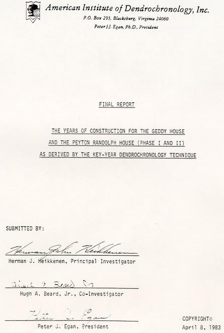 Title Page of Final Report with American Institute of Dendrochronology insignia
Peyton Randolph House, Phase I
The cross dating of the Peyton Randolph House, Phase I, is based on tulip-poplar samples removed from the ceiling of the second floor. The tulip-poplar trees used to construct the joists, sleepers and a valley plate had completed the growing season of 1715. The fresh condition of the wood and lack of evidence of bark-infesting insects suggest the tulip-poplar trees were felled, hewed, sawn and put into the house frame within a short period of time. Thus the ceiling of the second floor is believed to have been constructed during the spring/summer of 1716.
Roof Structure: The unusual structure of the roof consists of three parallel frames with the valleys above two oak gutters.
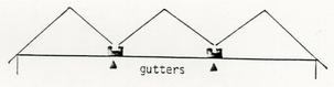 The two oak gutters were hewed from rapidly growing red oaks; thus the number of annual rings provided a pattern of only 54 years. The two oak joists were combined with the gutters to form a KY pattern 38 years having 6 +KY and 8 -KY (P = .13., n = 7) (Fig. 18). The combined oak KY pattern from the Peyton Randolph House, Phase I, was cross dated against the following combinations of area KY patterns:
| Key Year Patterns | Year of Best Fit | ||
|---|---|---|---|
| 1 | 2 | 3 | |
| Oaks | 1718 | 1948 | 1841 |
| Pine (Geddy) | 1773 | 1690 | 1711 |
| Oak/pine | 1718 | 1948 | 1690 |
| Oak/pine/tulip-poplar (PRI) | 1948 | 1841 | 1911 |
| Tulip-poplar (PRI) | 1736 | 1707 | 1651 |
| Tulip-poplar (PRII) | 1824 | 1776 | 1842 |
The varying years of best fit suggest that the oak KY pattern from the Peyton Randolph House is extremely limited both in sample size and in length of pattern.
The last year of tree growth for the oak gutters cannot be established with any degree of certainty using the currently available tree-ring data.
Shingles: The shingles used to cover the W-shaped roof structure are cypress (Taxodium spp.). None of the shingles had edge; thus the annual rings were not measured for this study. However, of importance is the amount of surface loss on the exposed butt ends, the maximum amount being one-eighth inch on each of four shingles. The "rule of thumb" for weathering (non-abrasive) of wood is one-fourth inch per 100 years. Accounting for the extreme durability of cypress to weathering, the amount of surface loss suggests the shingles were exposed to the weather for a considerable period of time.
Rafters: The rafters (R2 ) forming the present roof of the Peyton Randolph House, Phase 1, are believed to have been added (spliced above plate [P]) to the rafters (R1 ) forming the original W-shaped roof.

The wood samples used in this study (n = 5) were taken from what are believed to be the original rafters (R1 ). There were three wood samples removed form the later addition (R2 ) to form the present roof; however, two were of tulip-poplar heartwood and thus provided no data regarding the closing of the roof structure. The third wood samples was of tulip-poplar, had a bark edge and was cross dated with the tulip-poplar rafters in the Peyton Randolph House. Phase II.
Thus the closing of the W-shaped roof of Phase I may have occurred during the construction of Phase II of the Peyton Randolph House.
-34-The original tulip-poplar rafters (R1) from the Peyton Randolph House, Phase I, provided five suitable samples for a key-year pattern (Fig. 19). This KY pattern could not be cross dated with the tulip-poplar KY pattern of the joists/sleepers/plate (Fig . 20), suggesting the trees were not felled in the same year. Further evidence the trees were not felled in the same year is suggested by the drastic reduction in the number of KY years when the two patterns are combined at the 0 year (Fig. 21).
The KY pattern for the rafters (R1 ) from the Peyton Randolph House were then cross dated against the following combinations of area KY patterns:
| Area Key-Year Patterns | Year of Best Fit | ||
|---|---|---|---|
| 1 | 2 | 3 | |
| Oak | 1716 | 1703 | 1707 |
| Pine (Geddy) | 1744 | 1758 | 1716 |
| Oak/pine | 1707 | 1763 | 1977 |
| Tulip-poplar (PRI) | 1725 | 1656 | 1703 |
| Tulip-poplar (PRII) | 1819 | 1789 | 1821 |
| Oak/pine/tulip-poplar | |||
| 1982-1607 | 1707 | 1963 | 1977 |
| 1900-1800 | 1882 | 1819 | 1823 |
| 1800-1700 | 1707 | 1703 | 1716 |
When the tulip-poplar KY pattern for the rafters (R1 ) of the Peyton Randolph House, Phase I, was cross dated against the various combinations of area KY patterns, the most significant year of best fit for the last year of tree growth was 1716.
| Area Key-Year Patterns | Year of Best Fit | Chi-Square Value | Kappa Value |
|---|---|---|---|
| Oak | 1716 | 8.0 | 1.0 |
| Pine | 1744 | 5.0 | 1.0 |
| Oak/Pine | 1707 | 7.0 | 1.0 |
| Tulip-poplar (PRI) | 1725 | 5.0 | 1.0 |
| Tulip-poplar (PRII) | 1819 | 3.9 | .72 |
| Oak/pine/tulip-poplar | |||
| 1982-1607 | 1707 | 8.0 | 1.0 |
| 1900-1800 | 1882 | 5.0 | 1.0 |
| 1800-1700 | 1707 | 8.0 | 1.0 |
Thus the key-year patterns for the structural members for the ceiling and roof of the Peyton Randolph House, Phase I, were combined at the year of best fit with the area oak KY pattern as follows: Also, see Fig. 22.
| I) | Joists/sleepers/plate: | 1715 |
| II) | Rafters (R1): | 1716 |
| III) | Gutters/joists: | 1718 |
The combined tulip-poplar/oak KY pattern was then cross dated with the area oak/pine KY pattern. The year of best fit was 1718 (P = .05, n = 14) (Fig. 23).
Possible Construction Years: The construction of the second floor and the roof of the Peyton Randolph House, Phase I, based on the years of best fit of the tulip-poplar and oak KY patterns when cross dated with the area oak and area oak KY patterns may have been as follows:
| Second floor ceiling | Last year of tree growth |
| Joists/sleepers/plate | 1715 |
| Roof | |
| Rafters (R1 ) | 1716 |
| Roof Structure | |
| Gutters | 1718 |
Peyton Randolph House, Phase II
The cross dating of the Peyton Randolph House, Phase II, is based on tulip-poplar samples removed from the ceiling of the second floor and the roof. The KY pattern developed for the rafters, purlins, joists and summer was cross dated with the area oak/pine key-year pattern at 1821 (pg.24).
Also, the key-year pattern was cross dated with the following combinations of KY patterns:
| Area Key-Year Patterns | Year of Best Fit | ||
|---|---|---|---|
| 1 | 2 | 3 | |
| Oak | 1821 | 1900 | 1890 |
| Pine (Geddy) | 1767 | 1788 | 1770 |
| Oak/pine | 1821 | 1900 | 1890 |
| Tulip-poplar (PRI) | 1719 | 1684 | 1738 |
| Oak/pine/tulip-poplar | 1821 | 1900 | 1890 |
The most significant year of best fit was 1821 for the oak, oak/pine, and the oak/pine/tulip-poplar KY patterns.
| Area Key-Year Patterns | Year of Best Fit | Chi-Square Value | Kappa Value |
|---|---|---|---|
| Oak | 1821 | 14.5 | .81 |
| Oak/pine | 1821 | 14.5 | .81 |
| Oak/pine/tulip-poplar | 1821 | 14.5 | .81 |
| Pine | 1767 | 8.0 | 1.0 |
| Tulip-poplar | 1719 | 6.0 | 1.0 |
The possibility was investigated that the tulip-poplar KY pattern for the Peyton Randolph House Phase II, cross dated with the area oak/pine KY pattern at the year 1767 (Fig. 24). The goodness of fit at the year 1767 was not significant.
APPENDIX 9
THERMOLUMINESCENCE DATING
REPORT ON A BRICK FROM WILLIAMSBURGH - OXFORD ref: 381h19
28G - structure D. Peyton - Randolf site
A brick from Williamsburgh was submitted to the Oxford Laboratory for a dating feasibility study. The most obvious way of assessing the problems was to attempt to date the brick but limiting the number of measurements with the aim of producing an approximate date within 12-15% error limits.
Two methods of analysis were used: fine grain dating and pre-dose dating on quartz inclusions.
The procedures are described below and the results are tabulated. Our conclusions are recorded at the end.
Sample preparation
A fragment was extracted from the brick in a region as far away from the outer surface as possible (see diagram)
 This was to minimise the effects of the environmental contribution from the soil and surroundings. (Most of the gamma contribution was then assumed to be self dose from the brick and surrounding bricks).
The fragment was crushed in a vice and fine grains deposited on aluminum discs. The larger fraction was ground in a pestle and mortar and sieved to obtain large grains between 75 and 125 m in size. Quartz inclusions were extracted by magnetic separation and used for predose dating.
Fine Grain Analysis
Glow curves the natural, and natural + artificial irradiation are shown below. Prior to measurement, a zero glow monitor of 5 rads was applied and used for normalisation. This technique has hitherto been confined to sediment dating but has been used successfully for authenticity work in this laboratory.
Measurements were carried out using a 7-59 Corning filter at a heating rate of 20°/sec. The natural glow curve was a rather "dirty" shape and the artificial glow curve exhibited a large peak at 225°C. This would be consistent with thermoluminescence dominated by felspars in addition to the quartz. Despite the poor glow shape and reproducibility of only 15%, a plateau was obtained between 300°C and 400°C but the signal from the natural thermoluminescence was weak - 1.4 kps at 325° even at the high heating rate. Approximately 10% fading was observed in the second glow after 3 weeks. Using the theory propose by Visosekas, this would predict a total fading of 18% in 150 years.
Results:
| ED = 65 rads (uncorrected for fading) | |
| Estimated minimum | ED = 71 rads (corrected for known 10% fading) |
| Estimated total | ED = 76.7 rads (corrected for estimated 18% fading) |
Quartz inclusion method
After magnetic separation a large quantity of quartz was obtained and when observed under the microscope, a mixture of both frosty and shiny grains were seen with some red/brown staining on many grains - presumably iron. The grains were not etched.
Predose measurements were carried out on these quartz grains which were stuck onto aluminum discs using Viscasil. Viscasil has proved better than Silspray for keeping grains in place as it does not evaporate as quickly at 500°. Grains are placed onto aluminum discs rather than directly on the plate as contamination of the plate, which is hard to remove, has been observed on many previous occasions when grains are heated in this way.
Measurements were carried out as before using a 7-59 Corning filter and a heating rate of 20°C/sec.
Our normal procedure for predose measurements is to measure So, SN , SN 1 and SN+ß on each disc, varying ß for each disc. On this occasion, a 5 rad beta dose was used and additional ß doses of 53, 83 and 154 rads. ED's of 29, 28 and 24 rads were calculated giving a mean ED of 27 rads. The mean intensity of SN was 200 kps - clearly the heating rate could be considerably reduced and even better accuracy obtained. The intensity of So was 16% of SN . The grains were unetched. The alpha contribution to the predose of 100 m grains can be assumed to approach zero.
Radioactivity analysis
Some emanation was observed from the soil (up to 14%) and a maximum of 5% from the brick. The emanation from the brick was within the error limits of the alpha counting.
The site is assumed in this instance to be 75 ± 25% saturated since burial giving an uncertainty of 5% in the date.
The environmental contribution is assumed to be 75% self dose from the brick itself and the surrounding bricks and 25% from the soil. The cosmic contribution is assumed to be 0.014 mR/annum.
The measurements are tabulated below:
| BRICK | SOIL | |
|---|---|---|
| Alpha count unsealed (count/ks) | 15.8 ± 0.5 | 8.5 ± 0.3 |
| Alpha count sealed (count/ks) | 16.6 ± 0.3 | 9.8 ± 0.3 |
| Saturation water content | 16% | 27% |
| K2 O % | 0.91 | 0.27 |
Preliminary dating
FINE GRAIN
Using the assumptions mentioned in previous paragraphs and taking the mean alpha count of the brick to equal 16.2 cts/ksec and the mean alpha count of the soil to equal 9.2 cts/ksec we obtain:
| dose rate (rads/annum) | AGE | ||||||
|---|---|---|---|---|---|---|---|
| ED (rads) | a | a | ßuth | ß K2 O | ?+cos | total dose rate (rads/annum) | |
| 65 | 0.19 | .335 | .104 | .056 | .104 | 0.599 | 106 yr |
| 71 | 118 yr | ||||||
| 76.7 | 128 yr |
100 m QUARTZ: PREDOSE
| dose rate (rads/annum) | AGE | ||||||
|---|---|---|---|---|---|---|---|
| ED (rads) | a | a | ß uth | ß K2 O | ? +cos | total dose rate (rads/annum) | |
| 27 | 0 | 0 | .104 | 0.056 | 0.104 | 0.264 | 102 yr |
Conclusions
The ED from the predose analysis seems much lower than expected. Thermal activation analysis was carried out up to 500°C and the TAC's for So -SN and SN 9 -SN+ß (ß = 36 rads) are shown below. The strange behaviour could be due to grains moving on the plate but it is recommended that further investigation of the TAC should be carried out before any dating measurement made after activation to the temperature corresponding to the peak of the TAC.
It will be noted that there has been no attempt to evaluate the errors in these preliminary calculations but we estimate that errors of ±15% would not be unreasonable.
We consider that TL dating for further material from Williamsburgh would be a very feasible proposition so long as predose measurements on quartz inclusions is attempted after preliminary investigation of the TAC and so long as the material is similar to that studied at Oxford.
We reserve judgement on our environmental assumptions as we are not acquainted with the site and climatic conditions nor with the conditions of burial of the brick.
 Graph - Glow Curves
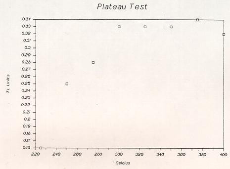 Graph - Plateau Test
 Graph - T.A.C. 150°- 500°
APPENDIX 10
DENDROCHRONOLOGY REPORT, 1984
Note: This appendix contains only that part of the report concerned with the Peyton Randolph House. The full report is on file in the Department of Architectural Research, Colonial Williamsburg Foundation.
INDEX
| I. Introduction | 1 |
| II. Description of Study Area | 2 |
| III. Description of Historical Structures | 4 |
| A. Bruton Parish Church | 6 |
| B. Public Records Office | 7 |
| C. Redwood Ordinary | 8 |
| D. James Geddy House | 9 |
| E. Ludwell-Paradise House | 10 |
| F. Brush-Everard House | 11 |
| G. John Blair House | 12 |
| H. Peyton Randolph House | 13 |
| IV. Description of Key-Year Technique | 14 |
| V. Key-Year Pattern - Living Trees | 15 |
| VI. Key-Year Pattern - Historical Structures | 20 |
| VII. The Crossdating of Bruton Parish Church - Bell Tower | 21 |
| VIII. The Crossdating of the Public Records Office | 23 |
| IX. The Crossdating of Bruton Parish Church | 27 |
| X. The Crossdating of Redwood Ordinary | 33 |
| XI. The Crossdating of the James Geddy House | 37 |
| XII. The Crossdating of the Ludwell-Paradise House | 40 |
| XIII. The Crossdating of Brush-Everard House | 44 |
| XIV. The Crossdating of the John Blair House | 49 |
| XV. The Crossdating of the Peyton Randolph House | 56 |
| XVI. Summary | 59 |
| XVII. Appendix | 64 |
XV. THE CROSSDATING OF THE PEYTON RANDOLPH HOUSE
The crossdating of the Peyton Randolph House is based on wood samples removed on June 29-30, 1982 and December 23, 1982. A total of 137 samples have been removed from the attic and walls. The location and description are recorded (Appendix PR).
Phase I:
The KY patterns of the tulip-poplar and oak of the Peyton-Randolph House Phase I have not been derived. The problems encountered are attributed to:
- (1) short tree-ring patterns,
- (2) possible missing and/or multiple rings,
- (3) possible reuse of structural timbers,
- (4) sampling from only the attic, and
- (5) possible use of tulip-poplar from beyond the study area.
The above problems can be resolved by:
- (1) an accurate, detailed architectural drawing of the structural members,
- (2) additional sampling of attic timbers without wane edge,
- (3) sampling from the basement; also the walls of the first and second stories, both interior and exterior, and
- (4) additional studies to expand both the Colonial Williamsburg and the study area tulip-poplar KY pattern.
Phase II:
The KY pattern of the tulip-poplar of the Peyton Randolph House Phase II is based on a total of 23 samples from the walls and ceilings of the second floor and roof. The location and description of the samples are recorded (Appendix PR).
The KY pattern for the Peyton Randolph House Phase II is based on 24 tulip-poplar samples from the attic, three from the walls, and one reused rafter from Phase I as follows:
| rafter, common: | 8 | summer: | 1 |
| rafter, principal: | 1 | joist: | 7 |
| rafter, reused, PR1: | 1 | corner post: | 1 |
| purlin: | 3 | stud, wall: | 2 |
These 24 samples were selected for deriving the KY pattern, based on having the greatest number of years within each of seven distinct tree-ring patterns. The width of each annual ring on each sample was measured and entered into the data bank.
The tulip-poplar KY pattern derived (n = 24, P = .05) had 14 +KY, 16 -KY and was 67 years in length. This KY pattern was crossdated by aligning it, year by year, with the area tulip-poplar KY pattern from the first to last year of possible overlap. The year of best fit was 1753 (X2 - 16.6, K = .83)(Fig. 29).
The occurrence of a multiple ring (two rings within one growing season) was encountered for the first time in all the tulip-poplar samples from the Peyton Randolph House Phase II. The multiple ring occurred during the growing season of 1728. The year 1728 was extremely dry throughout the Chesapeake Bay region. Losses are recorded of animals (hogs and cattle), crops, (corn and tobacco), and infestations of flies and defoliating insects in the woods.
The analytical techniques to identify and verify the phenomenon of a multiple ring consumed two men for eight months.
58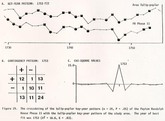 Figure 29. The crossdating of the tulip-poplar key-year pattern (n = 24, P = .05) of the Peyton Randolph House Phase II with the tulip-poplar key-year pattern of the study area. The year of best fit was 1753 (X2 = 16.6, K = .83).
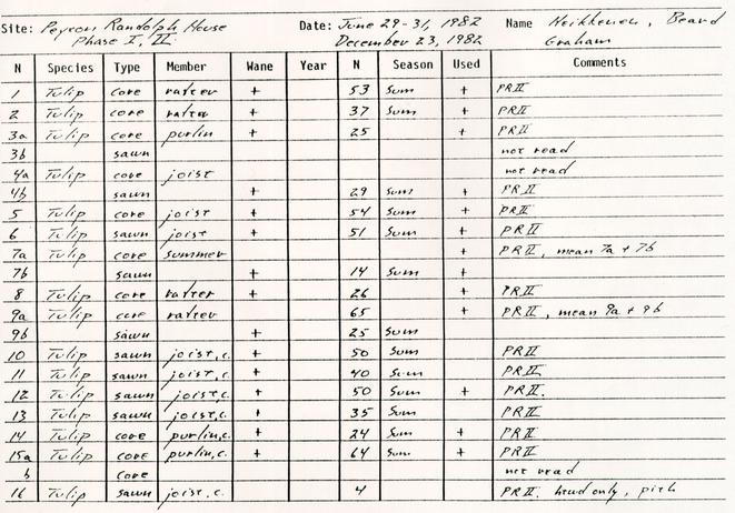


APPENDIX 11
ANALYSIS OF TWENTIETH-CENTURY CISTERN DEBRIS
A Twentieth Century Time Capsule
in Williamsburg, Virginia
by
Leslie McFaden
and
Susan Alexandrowicz
Department of Archaeology
Office of Excavation and Conservation
Colonial Williamsburg Foundation
Paper Presented at the 18th Meeting of the Society for Historical Archaeology, Boston, 1985
The subject of this paper is the fill from the brick-lined, vaulted cellar which was excavated at the Peyton Randolph Site during the summer of 1984 (Figure 1). While the cellar dates from the eighteenth-century, the fill consisted almost entirely of early twentieth-century artifacts. A Homer Laughlin plate bearing the manufacturer's date code provided a terminus post quem date of 1926 for the deposit. In 1938, James Knight, former architectural historian for Colonial Williamsburg, encountered the cellar in a partial excavation of the Peyton Randolph lot, suggesting that the area was disturbed for some years prior to his excavations. Therefore the filling episode must have ceased between ca. 1926 and ca. 1938.
An attempt to pinpoint the filling episode through oral history interviews was unsuccessful. Neither the woman who grew up in the Peyton Randolph House during the 1920s and '30s, nor a former neighbor, remembered a cellar or any similar structure in the back yard of the house into which their parents threw trash. Because childhood memories are not all-encompassing, it seems logical to assume that the artifacts recovered from the cellar did originate from the Peyton Randolph house.
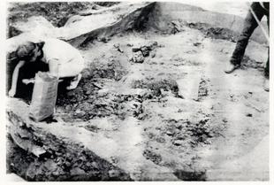 Figure 1. Excavation of Cistern Fill.
The artifacts date roughly to the first three decades of the twentieth century and range from car parts and architectural hardware to combs and pain cans. A small percentage of the assemblage does indeed date to the eighteenth and early nineteenth centuries; it includes black wine bottle glass, Chinese export porcelain and a fragment of pearlware. It is felt, however, that these items yard debris of the sort that routinely surfaces or is exposed on colonial lots in Williamsburg. Those artifacts, then, were excluded from the following analysis, which focuses on food related items: glass and ceramic vessels and tin cans.
Due to both time constraints and the sheer quantity of artifacts, the fill from the cellar was not screened. Therefore the sample and possible the results may be skewed.
CERAMICS
For analysis, the ceramic artifacts have been divided into the following categories: teaware, toiletware and tableware. Glass drinking vessels are also included in the tableware grouping. All figures are based upon minimum vessel counts.
Four items of toiletware are presented in the assemblage. They include one stoneware slop jar lid, one whiteware wash basin and fragments of possibly two additional wash basins. A windmill pumped water from a well into the house prior to 1900; this system of running water may have made unnecessary a large collection of wash basins, ewers, chamber pots and slop jars.
The distinction between teaware and tableware is based primarily on the two ceramic types present in the assemblage: English and American whiteware and white ironstone; and porcelain, mostly imported from France and Austria. Tablewares are represented by thirty-four whiteware vessels; fifty percent of these vessels are dinnerplates averaging nine to ten inches in diameter. Small bowls or nappies, cups, saucers, platters and a butter pat account for the remaining whitewares. No dinner-size plates are present among the porcelain vessels: only small plates measuring five to six inches in diameter. The porcelain teawares consisted of twenty-four vessels in all. In addition to small plates, cups, saucers, bowls and a platter comprise this grouping.
Roughly a third of both whiteware and porcelain vessels are either undecorated white or have a plain gilt edge. However, the undecorated whitewares tend to be heavy, so-called utilitarian forms in contrast to the finely potted porcelain items. Catalogs of the period reflect this distinction between undecorated whiteware and undecorated porcelains.
Fragments of a Rockingham glazed coffee urn complete the teaware grouping, while nine glass tumblers, complete the tablewares.
Finally, there is evidence of sets being purchased in the assemblage. Furthermore, the artifacts suggest that replacements were bought with an eye towards obtaining a similar but not necessarily identical design to match sets previously purchased. This purchasing pattern is closely related to availability of goods, whether from mail order catalogs or the local stores.
Seven vessels are of Blue Willow pattern. Two willow plates have been identified on the basis of maker's marks as having come from the same set. An additional willow plate and saucer match each other, and were probably purchased at the same time. Two more willow plates and a platter each appear to have been purchased later and vary slightly from the other vessels.
The second identifiable set is transfer-printed in a "flow blue" pattern on whiteware. Two plates and a cup match each other, while a bowl and a cup are each printed with similar "flow blue" designs.
A set of porcelain table and teaware decorated with blue floral decalcomania includes demitasse saucers, a cup, small bowl and platter. Decorated in a similar yet different motif are a plate and three bowls.
The undecorated white porcelain vessels are all slightly different in form, but perhaps presented a uniform appearance to those using them.
Four glass tumblers decorated with a grapevine design comprise a final set.
CANS
During the cellar excavations, only those cans which were relatively structurally sound were saved. This sample consists of fifty-seven cans, of which sixty-four percent were of the modern crimped-top type which was developed around the turn of the century. Only nine percent of the cans were of the older hole-in-cap type. Over one-half of the can sample were food or evaporated milk cans; one-third were tobacco cans and the remainder contained such things as paint, O'Cedar floor polish and probably shoe polish.
All but one of the tobacco cans were Prince Albert. Here, the oral history did support the evidence recovered in the trash deposit, since our informant's father did smoke Prince Albert tobacco. It was discovered that Prince Albert was one of the most commonly advertised tobaccos of the time in Williamsburg.
By the late 1920s many foods and other products were available in cans in Williamsburg. For instance, a local A&P store advertised canned goods including Campbell's Beans, Karo Syrup, Delmonte Spinach, and Armour Corner Beef. Nationally advertised and marketed foods had become firmly established during the 1920s. The sales pitch of the manufacturer was to get housewives out of the kitchen as much as possible. This was in marked contrast to the late nineteenth-century when most food was prepared from scratch in the home.
BOTTLES
One hundred and fifty-seven bottles were found in the cellar fill which were analyzed by functional type food, medicine, liquor, canning jar, etc. Forty-one percent of these bottles were mouth-blown and date prior to the. 1920s. Represented in the assemblage were various regional and nationally advertised products from as far away as Wisconsin and Missouri. During the 1920s there was an increase in paved roads which made shipping goods to the consumer much easier. With increased mass marketing and promotions and quality control, certain goods became more familiar and desirable to the shopper of this era. Food-type bottles represent thirty-one percent of the total assemblage. Of these forty-eight bottles, eleven were Sauer's Extracts which is produced in nearby Richmond, Virginia. also represented were McCormick's Extract from Baltimore, tabasco sauce from New York and Horlick's Malted Milk from Wisconsin.
The next largest category of bottles was medicines. Although twenty-three percent of the bottles fall into this category, it is interesting to note that our informant did not remember her family using much medicine. If local Virginia Gazette newspapers from the 1920s are any indication, it would seem that the citizens of Williamsburg were bombarded weekly with advertisements for remedies designed to cure every ailment imaginable. Eight percent of the bottle assemblage, represented by a minimum of thirteen vessels, were canning jars. Although this
 Figure 2. Glass bottles from the Cistern Fill.
would seem to indicate that preserving food was one of the chores of the household, our interview revealed that this was not the case. The interview did reinforce conclusions based on the analysis of liquor and soft drink bottles. Whiskey was kept in the house by our informant's father and this was evident by the recovery of ten whiskey bottles. Since prohibition began in 1919 these bottles may indicate that filling of the cellar started before the 1920s. Also, it was stated that soft drinks were not generally consumed in the household; the 1984 excavations found no soda bottles.
In conclusion, evidence from the fill of the cellar indicates that the deposit does not date much later than the 1920s, as evidenced by liquor bottles, mouth-blown containers and hole-in-cap tin cans. The 1926 Homer Laughlin plate indicates that filling of the cellar was not complete until after that date. The fact that this deposit was re-encountered in 1938 by the Knight excavations implies that the area was stable some years before then.
Analysis of the artifacts suggests that ceramics were purchased in sets and that table and tea sets were purchased separately. Food-related bottles, jars and cans indicate a growing participation in a national market and changing patterns of food preparation that involved conveniently packaged food, which cut down on time spent in the kitchen.
APPENDIX 12
ANALYSIS OF OYSTER SHELL
Note: Unfortunately, Messrs. Doms and Custer apparently misunderstood the temporal context from which the oyster shells they examined came. The shells were from early eighteenth-century planting beds, not late eighteenth-century as they state in their report. Whereas this misunderstanding may invalidate some of their interpretations, the season of harvest and the discussion of waters from which the shells were harvested remain valid
PRELIMINARY REPORT ON OYSTER SHELLS FROM THE PEYTON RANDOLPH SITE
by
Keith R. Doms and Jay F. Custer
Center for Archaeological Research
Department of Anthropology
University of Delaware
ABSTRACT
Preliminary analysis of an oyster shell sample from a late 18th century planting bed feature at the Peyton Randolph site shows that the oysters were primarily collected during the late fall and the early winter. All of the oysters were collected from sandy mud flats in waters that varied in salinity from below 10 ppt for most of the year to above 20 ppt for at least half of the year. Absence of ribbing on the shells indicates that they were probably collected from waters more than 4-5 feet deep and most likely were collected by tonging.
February 1985
INTRODUCTION
The purpose of this short report is to provide a preliminary analysis of a sample of oyster shells from a late-18th century planting bed discovered at the Peyton Randolph site. The study specifically sought to identify patterns in collecting environments, season-of-death, and opening techniques. The methods used in the study were drawn from the work of Brett Kent (n.d.) and are comparable to methods used in other studies of oyster shells from archaeological sites (Doms and Custer 1983).
COLLECTING ENVIRONMENT
Three types of data were collected to determine the environment from which the oyster shells were collected. First, the basic shape of the oysters was noted. Morphometric analysis of oysters living in varied environments has shown that shell shape can be correlated with water depth and substrate. The oysters from the Peyton Randolph site are less than two times as high as they are long indicating that they are mud flat oysters which grew in relatively shallow waters (less than 6 feet in depth) on a hard sandy-clay bottom.
Presence/absence of parasite bore holes can also be analyzed to determine the salinity of the water within which the oysters lived. Figure 1 shows the frequency distribution of the Peyton-Randolph oysters for varied salinity regimes. The most common salinity regime is one in which salinity is below 10 ppt for about ¼ of the year, below 15ppt for about ½ of the year, and occasionally above 20 ppt.
Presence/absence of ribbing was also noted on the shells. The presence of ribbing indicates that the shells were exposed to sunlight for at least part of the day. Only 5 of the 50 shells in the sample showed any ribbing and this indicates that the oysters lived in water that was probably more than 3 feet deep, or deeper, at low tide.
SEASON-OF-DEATH
Microscopic analysis of growth rings on the hinge area of the shells was carried out to determine the season of death of the oysters. Figure 2 shows the frequency distribution of the sample for varied seasons of death and a fairly tight range between late fall through winter is noted.
OPENING TECHNIQUES
All of the shells in the Peyton Randolph sample were opened by breaking off the distal (non-hinge end). In some cases the breakage took place more than 1/3 of the way up the shell. This kind of opening technique would have produced lots of shell fragments which probably entered the meat and would have been troublesome when the oysters were eaten unless some special preparation, which removed the shell fragments, was practiced.
DISCUSSION
The oyster shell sample from the Peyton Randolph site shows consistent collecting environments and season-of-death. Collecting environments are moderate salinity waters that were more than 3 feet in depth at low tide and probably less than 6 feet in depth at high tide. Given these kinds of water depths, the oysters were probably collected by tonging. Season-of-death data indicate that most of the oysters were collected during the late fall through winter into the early spring.
It is interesting to note that the Peyton-Randolph sample shows more internal consistency in season-of-death and collecting environment than a series of samples from a mid- to late-19th century context in urban Wilmington. The variation in the later urban assemblages may be due to redistribution of shellfish through markets. Therefore, the consistency of the Peyton-Randolph sample may indicate that such a marketing system did not exist in the Williamsburg area during the late 18th century.
REFERENCES CITED
- 1983
- Analysis of Oyster Shell Remains and other Ecofacts from a Late Woodland Pit at the Island Field Site (7K-F-17), Kent County, Delaware. University of Delaware Center for Archaeological Research Report No. 2. Newark.
- n.d.
- Making Old Oysters: A Manual for Oyster Shell Analysis. Maryland Historical Trust Monograph Series (in press).
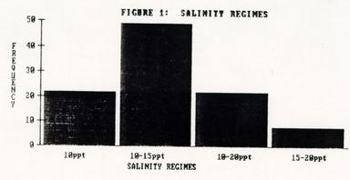 GRAPH
GRAPH
FIGURE 1: SALINITY REGIMES
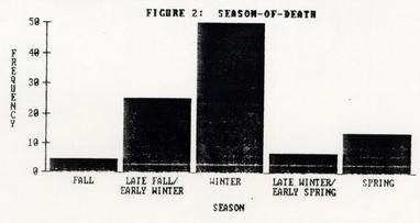 GRAPH
GRAPH
FIGURE 2: SEASON-OF-DEATH
APPENDIX 13
ANALYSIS OF FAUNAL REMAINS FROM PLANTING BEDS
The Peyton Randolph Planting Beds: A Discussion of the Non-Dietary Use of Bone
Joanne Bowen Gaynor
Staff Zooarchaeologist
Department of Archaeology
Office of Excavation and Conservation
The Colonial Williamsburg Foundation
Paper Presented at the 18th Meeting of the Society for Historical Archaeology, Boston, 1985
The Peyton Randolph Planting Beds: A Discussion of the Non-Dietary Use of Bone
Joanne Bowen Gaynor
Staff Zooarchaeologist
Colonial Williamsburg Foundation
Along with the thousands of bottle glass fragments and oyster shell, the Peyton Randolph planting beds contain a substantial number of faunal remains (Figure 1). Reasons why they were intentionally placed on the base of the beds have yet to be determined, but it is clear that the beds are discrete garden features and that the bone was used as a construction material. Because the beds were features built for a specific purpose, dated to the first quarter of the 18th century, and are clearly associated with the houselot, one might be tempted to think of these beds as primary archaeological features. But, in a sense, these features are secondary deposits because the contents are redeposited artifacts and no direct association with the site's occupants can be demonstrated. The bones, for example, could have been obtained from a local butcher, a number of which have been identified as being present in 18th century Williamsburg.
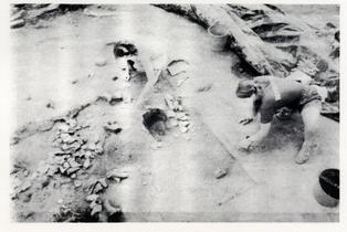 Figure 1. Excavation of Planting Bed 3.
We must, therefore, consider them to be secondary refuse and carefully assess what these bones represent. On the surface, they all have the appearance of most faunal assemblages we think of as being food remains. They are disarticulated, many are highly fragmented, a number of species are represented, and most display visible butcher marks. But both the relative proportions of identified species and the range of species present are quite different from most other assemblages. They are clearly not food remains and must be recognized as bones re-used as construction material in the planting beds.
As I thought of these bones being basically a construction material, my first thought was that most types of faunal analysis would be inappropriate. In this paper I will discuss how analytical methods have trouble dealing with non-food uses of bone, describe characteristics of this faunal assemblage that support this notion of their being secondary refuse, and assess how this planting bed assemblage might be analyzed.
Unfortunately, almost all analysis of faunal remains has traditionally been based on the assumption that fragmented archaeological bones are dietary remains (Binford 1981:3-20, 1983:33-59). Studies of adaptation, seasonality, settlement patterns, and social and economic status, all draw upon faunal data and focus on some form of dietary analysis. Not unexpectedly, quantification methods used are almost exclusively aimed at some aspect of subsistence. Quite frequently, the corner-stones of faunal analysis—frequency counts, minimum numbers of individuals, and some version of a minimum weight estimate are aimed at determining the relative importance of animals, either in species or specific cuts of meat in the diet. These methods, in my mind, do not adequately demonstrate the non-food characteristics of this archaeological context— particularly if too much reliance is placed on them as a data source.
There is an increasing skepticism by zooarchaeologists on the validity of these analytical methods. From a taphonomic viewpoint, this level of skepticism is healthy. Bones which come out of the ground can little or no resemblance to what went on in the ground. Once butchered, bones are influenced by a long series of natural factors and man related activities. Among these are secondary alterations to the bone during the preservation and cooking procedures, and the equally devastating post-depositional factors such as human, carnivore, and rodent activity. And given the different kinds of archaeological contexts. which provide varying degrees of protection to the bone, the preservation of faunal remains can vary widely. It becomes difficult, if not impossible, to get accurate counts of the animals actually represented in the site.
Yet despite this important drawback in our faunal data, we continue to emphasize—at least from a theoretical point of view—the analysis of subsistence systems. While we question the validity of frequency counts, MNI, and minimum weight estimates, we have tended to either reject them, or focus our energies on refining methods. At least as much time should be spent on examining theoretical assumptions.
From the early years of faunal analysis there has been a recognition of bone being used for non-food purposes. The most commonly recognized is the re-use of bone as tools. But until recently, this aspect of analysis has been left to the archaeologist, who most often sent these bones to the zooarchaeologist only to verify them as being bone. Not surprisingly, these fragments have seldom been included in the zooarchaeological reports. Thus, even the re-use of bone has long been recognized, zooarchaeologists have not had ready access to tools or other modified bone. Both their theoretical framework and analytical methods reflect their emphasis on subsistence.
The Peyton Randolph planting beds are a good example of an archaeological context where traditional analytical methods, if taken as a standard measure of the relative importance of animals, might completely miss the importance of the deposit.
[portion of text appears to be missing]
[…]quite possible. Thus, even though these bones are not from primary archaeological deposits, they can provide valuable information on several aspects of agriculture, economics, animal husbandry, butchering, and meat preparation.
Bibliography
- 1981
- Bones: Ancient Men and Modern Myths. New York, Academic Press.
- 1983
- In Pursuit of the Past. New York, Thames and Hudson.
- 1981
- "Taphonomy and Paleoecology: A Critical Review of Archaeology's Sister Disciplines." In Advances in Archaeological Method and Theory, Vol. 4, edited by M.B. Schiffer. New York, Academic Press.
- 1979
"Quantification of Vertebrate Archaeofaunas", In Advances in Archaeological Method and Theory, Vol. 2, edited by M.B. Schiffer. New York, Academic Press.- 1982
"Archaeofaunas and Subsistence Studies", In Advances in Archaeological Method and Theory, Vol. 5, edited by M.B. Schiffer. New York, Academic Press.